Los Adaes facts for kids
|
Los Adaes
|
|
| Lua error in Module:Location_map at line 420: attempt to index field 'wikibase' (a nil value). | |
| Location | Natchitoches Parish, Louisiana, USA |
|---|---|
| Nearest city | Robeline, Louisiana |
| Built | 1721 |
| NRHP reference No. | 78001427 (original) 93001622 (increase) |
Quick facts for kids Significant dates |
|
| Added to NRHP | June 7, 1978 |
| Boundary increase | November 4, 1993 |
| Designated NHL | June 23, 1986 |

Los Adaes was a very important place in what is now Louisiana. From 1721 to 1773, it served as the capital of Tejas, which was a part of New Spain (a large area controlled by Spain, including much of modern-day Mexico and parts of the U.S.). At Los Adaes, there was a Franciscan mission called San Miguel de Cuéllar de los Adaes. Missionaries worked there to teach Christianity to the local Adai people. There was also a fort, or presidio, named Nuestra Señora del Pilar de Los Adaes.
The main reason Spain built Los Adaes was to protect its land from the French, who were settling in nearby Louisiana. Spain wanted to stop the French from moving into its territory. The Adai people were Native Americans who lived in the area, and the mission hoped to convert them. However, in 1763, Spain gained control of Louisiana, so Los Adaes was no longer needed as a defensive outpost. In 1773, the Spanish government closed the mission and presidio, forcing everyone living there to move to San Antonio.
Today, the original site is preserved as the Los Adaes State Historic Site. It is located on Louisiana Highway 485 in Natchitoches Parish, Louisiana. In 1986, it was recognized as a National Historic Landmark because of its importance to history.
Contents
Why Los Adaes Was Built
Spain claimed a lot of land along the Gulf Coast of North America. But for most of the 1600s, Spain didn't pay much attention to the area east of the Rio Grande. This changed in 1699 when French forts were built at Biloxi Bay and along the Mississippi River. This meant Spain no longer had complete control of the Gulf Coast.
Spanish leaders realized that the French moving closer could threaten other Spanish areas. So, they decided to reoccupy Texas. This would create a buffer zone between New Spain and the French settlements.
Early Spanish and French Settlements
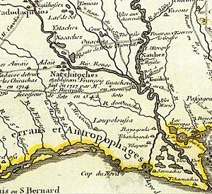
On April 12, 1716, an expedition led by Domingo Ramon traveled from San Juan Bautista to Texas. Their goal was to build four missions and a presidio. At the same time, the French were building a fort in Natchitoches, which they had founded in 1714.
To counter the French, Spain built two more missions just west of Natchitoches. One of these was San Miguel de los Adaes. These two missions were in a disputed area. France believed the Sabine River was the western border of its Louisiana colony. Spain, however, claimed the Red River as the eastern border of Texas. This left a disputed area about 45 miles (72 km) wide.
A Brief French Takeover
In 1719, European countries began fighting in a conflict known as the War of the Quadruple Alliance. In June 1719, seven French soldiers from Natchitoches took control of the San Miguel de los Adaes mission. The only Spanish defender there didn't even know that Spain and France were at war! The French soldiers claimed that 100 more soldiers were on their way. Because of this, the Spanish colonists, missionaries, and remaining soldiers quickly left the area and fled to San Antonio.
Spain Reclaims the Area
The Marquis de San Miguel de Aguayo volunteered to take back Spanish Texas. He gathered an army of 500 soldiers. By July 1721, Aguayo reached the Neches River. His group met a French force that was on its way to attack San Antonio de Bexar. The French soldiers, who were outnumbered, agreed to retreat to Louisiana.
Aguayo then ordered the building of a new presidio, Nuestra Señora del Pilar de Los Adaes. It was located near today's Robeline, Louisiana, only 12 miles (19 km) from Natchitoches. This new fort became the first capital of Texas. It was protected by six cannons and 100 soldiers. All six of the eastern Texas missions were reopened under the protection of this new presidio.
Challenges of Life at Los Adaes
Spain did not encourage manufacturing in its colonies. It also limited trade to only Spanish goods, handled by Spanish merchants, and carried on Spanish ships. Most ports, including all of those in Texas, were closed to other ships to stop smuggling. By law, all goods for Texas had to be shipped to Vera Cruz. Then, they were transported over mountains to Mexico City before finally being sent to Texas. This made goods very expensive in the Texas settlements.
Because Los Adaes was so far from other Spanish settlements in Texas, people living there often traded with the French colonists in nearby Natchitoches, Louisiana. However, the Spanish missionaries and colonists didn't have many goods to trade. This meant the local Native Americans often remained loyal to the French traders.
Even though the Spanish settlers didn't face hostile Native Americans (the local Caddoan-speaking people were friendly), the Franciscan missionaries struggled to convert them to Catholicism. After many years without success, the College of Nuestra Señora de Guadalupe de Zacatecas, which supported the missionaries, called them back in 1768. The mission was then closed.
The End of Los Adaes as a Capital
On November 3, 1762, France gave the part of Louisiana west of the Mississippi River to Spain as part of the Treaty of Fontainebleau. With France no longer a threat to Spain in North America, the Spanish king asked the Marqués de Rubí to inspect all the forts on the northern border of New Spain. Rubí was not impressed with Los Adaes. He noted that two Franciscan missionaries lived there, but after 46 years, they had done "little more...than baptize a few of the dying." Not a single Indian lived at the mission.
Rubí recommended that eastern Texas be abandoned and everyone moved to San Antonio. Since Louisiana was now controlled by Spain, there was no longer a need for a mission and presidio at Los Adaes to stop French competition. In August 1768, the acting governor, Juan María Vicencio, Baron de Ripperdá, moved his headquarters and the soldiers to San Antonio. San Antonio became the new capital of Tejas in 1772.
Forced Relocation and New Settlements
The settlers who lived near Los Adaes were forced to move to San Antonio in 1773. In the six years between Rubí's inspection and the move, the population of eastern Texas had grown from 200 people of European descent to 500 people. This group was a mix of Spanish-speaking, French-speaking, Indians, and a few Black individuals. The settlers were given only five days to get ready for the move to San Antonio. Many of them died during the three-month journey, and others died soon after arriving.
After many protests, the former residents of eastern Texas were allowed to leave San Antonio the next year (1774). However, they were not allowed to settle beyond the Trinity River, which was 175 miles (282 km) from Natchitoches. In 1779, the Comanches began raiding this new settlement. The former Los Adaes settlers then chose to move farther east to the old mission of Nacogdoches. There, they founded the town of the same name. This new town quickly became a place for contraband (illegal goods).
The site of Los Adaes was declared a National Historic Landmark in 1986. It is also a stop on the El Camino Real de los Tejas National Historic Trail.
Los Adaes Today
Today, the site of Los Adaes is near the town of Robeline, Louisiana. The Los Adaes site is one of the most important archaeological sites in the U.S. for studying colonial Spanish and Adai culture. The Adai Caddo Indians of Louisiana continue to share their history and culture related to this site.
Dr. Hiram F. "Pete" Gregory Jr., an archaeologist from nearby Northwestern State University, led important excavations at the historic presidio from the 1960s to the 1980s. In the 1990s, Dr. George Avery became the station archaeologist for the Los Adaes State Commemorative Area. He also made many important discoveries. While the site no longer has a full-time station archaeologist, Avery, Gregory, and other archaeologists continue to learn more about this important frontier outpost. Gregory, in particular, has pushed for more academic interest in Los Adaes and the colonial history of northern and central Louisiana.
Notable People from Los Adaes
- Nepomuceno de la Cerda (1752–1826), a Spanish soldier born in Los Adaes.
See also
- Adai Caddo Indians of Louisiana
- Adai people
- Adai language
- List of National Historic Landmarks in Louisiana
- Louisiana (New France)
- Louisiana (New Spain)
- Sabine River Spanish
- Spanish missions in Louisiana
- Spanish missions in Texas
- Spanish Texas
- Isle Brevelle
- National Register of Historic Places listings in Natchitoches Parish, Louisiana
- Anne des Cadeaux
- Louis Juchereau de St. Denis
- Natchitoches Parish
 | Misty Copeland |
 | Raven Wilkinson |
 | Debra Austin |
 | Aesha Ash |


