Lower Saucon Township, Pennsylvania facts for kids
Quick facts for kids
Lower Saucon Township
|
||
|---|---|---|

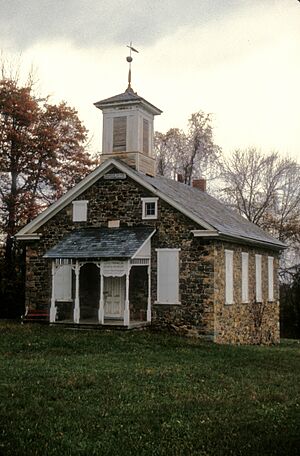
Lutz-Franklin School, built in 1880 in Lower Saucon Township, June 1970
|
||
|
||

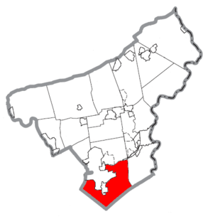
Lower Saucon Township in Northampton County Pennsylvania
|
||
| Country | ||
| State | ||
| County | Northampton | |
| Area | ||
| • City | 24.51 sq mi (63.48 km2) | |
| • Land | 24.27 sq mi (62.86 km2) | |
| • Water | 0.24 sq mi (0.62 km2) | |
| Elevation | 417 ft (127 m) | |
| Population
(2010)
|
||
| • City | 10,772 | |
| • Estimate
(2016)
|
10,813 | |
| • Density | 445.55/sq mi (172.02/km2) | |
| • Metro | 865,310 (US: 68th) | |
| Time zone | UTC-5 (EST) | |
| • Summer (DST) | UTC-4 (EDT) | |
| ZIP Codes |
18015 and 18055
|
|
| Area code(s) | 610 | |
| FIPS code | 42-095-45104 | |
| Primary airport | Lehigh Valley International Airport | |
Lower Saucon Township is a community in Northampton County, Pennsylvania, United States. It is called a township, which is a type of local government area. In 2010, about 10,772 people lived here.
Lower Saucon Township is part of the Lehigh Valley area. This larger area is home to many people. The township is located about 6 miles (9.7 km) east of Allentown. It is also about 59 miles (95 km) north of Philadelphia and 84 miles (135 km) west of New York City. If you live in the township, your mailing address might be Hellertown or Bethlehem.
Contents
History of Lower Saucon Township

Early Days: 17th Century Life
Before the mid-1600s, Lenape Native American tribes lived and hunted in the area of Lower Saucon Township. European traders arrived in the 17th century. The Lenape and Europeans often traded peacefully.
In 1681, William Penn received land from King George III. This land included what is now Lower Saucon Township. Penn realized he needed to buy the land from the Native Americans to truly own it. He offered land in Europe for a small price to encourage people to move there.
Settlement and Growth: 18th Century
In 1737, William Penn's sons gained more land through the Walking Purchase. This included most of the Lehigh Valley. The Lenape did not agree with this land claim. However, they eventually moved away, allowing Europeans to settle.
Nathaniel Irish was the first European settler in Lower Saucon Township. He started a farm and built mills before 1737. His land is now in Shimersville. He was also the first justice of the peace. The first main road from Philadelphia to the Lehigh Valley was built to his property in 1737.
Lower Saucon Township was officially formed in 1743. At that time, it was part of Bucks County. It was known for its rich farmland near Saucon Creek. The name "Saucon" comes from a Native American word, sakunk, which means "at the mouth of the creek." The township used to include parts of South Bethlehem and Hellertown.
Many German immigrants moved to Lower Saucon Township starting in the 1730s. They were encouraged by William Penn's descriptions of the New World. Families like Boehm, Wagner, and Heller were among the early settlers. These settlers worked hard, and their farms did well. Many mills were built for wood, flour, and other goods. People also mined zinc and iron ore.
During the Revolutionary War, many German farmers from the area joined the Continental Army. They helped fight the British. They even sold wheat and rye to the army when it needed supplies. In 1777, soldiers carrying the Liberty Bell to Allentown passed through Lower Saucon. The Marquis de Lafayette, a French hero, also stopped nearby during the war.
The first church, Lower Saucon Church, was built in 1734. It was started by a German Reformed group. Before Pennsylvania created public schools in 1834, local churches ran ten schools in the township.
Changes in the 19th Century
The North Penn Railroad was finished in 1856. This train line connected Philadelphia to Bethlehem. It helped the area's iron industry grow. Lower Saucon Township had a lot of iron ore and limestone. The railroad brought coal for the iron smelters and took pig iron to markets. It also provided travel for people living in the township.
Modern Times: 20th and 21st Centuries
Lower Saucon Township was affected when Bethlehem Steel closed down. Bethlehem Steel was once the second-largest steel maker in the world. Many of its leaders lived in Lower Saucon Township. The company was the biggest employer in the Lehigh Valley. When it stopped making steel in 1995, many people in the township lost their jobs.
Four places in Lower Saucon Township are listed on the National Register of Historic Places. These are special places that are important to history. They include Ehrhart's Mill Historic District, Michael and Margaret Heller House, Lutz-Franklin School, and Northampton County Bridge No. 15.
Geography and Nature
Lower Saucon Township covers about 24.3 square miles (62.9 km2). Most of this area is land. The township is part of the Delaware watershed. This means its water flows towards the Delaware River. The Lehigh River borders the township to the north.
There are nine small communities, or villages, within the township. These include Bingen, Colesville, Leithsville, Lower Saucon, Redington, Seidersville, Steel City, Wassergass, and Wydnor.
Neighboring Communities
Lower Saucon Township shares borders with several other towns and townships:
- Bethlehem (to the north and northwest)
- Hellertown (mostly surrounded by Lower Saucon)
- Freemansburg (to the northwest)
- Bethlehem Township (to the north)
- Easton (to the northeast)
- Williams Township (to the east)
- Springfield Township, Bucks County (to the south)
- Upper Saucon Township, Lehigh County (to the southwest)
- Salisbury Township, Lehigh County (to the west)
- Fountain Hill, Lehigh County (to the northwest)
Local Climate
Lower Saucon Township has a hot summer humid continental climate. This means it has four distinct seasons. Summers are warm and humid, while winters are cold. For example, average temperatures in Wassergass range from about 29°F (-2°C) in January to 73°F (23°C) in July.
Getting Around: Transportation
As of 2021, Lower Saucon Township had about 117 miles (188 km) of public roads. The township maintains most of these roads.
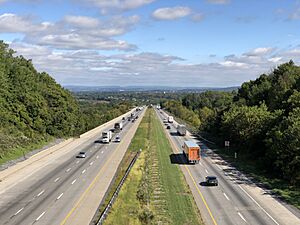
Interstate 78 is the main highway that goes through Lower Saucon Township. It runs from southwest to northeast. Other important roads include Pennsylvania Route 33, Pennsylvania Route 378, and Pennsylvania Route 412. These routes help people travel to and from the township.
People of Lower Saucon Township: Demographics
| Historical population | |||
|---|---|---|---|
| Census | Pop. | %± | |
| 2000 | 9,884 | — | |
| 2010 | 10,772 | 9.0% | |
| 2016 (est.) | 10,813 | 0.4% | |
| U.S. Decennial Census | |||
In 2000, there were 9,884 people living in Lower Saucon Township. There were 3,735 households, which are groups of people living together. Most people were white (96.73%). About 2.56% of the population was Hispanic or Latino.
The population included people of all ages. About 23.8% were under 18 years old. About 14.6% were 65 years or older. The average age in the township was 41 years. Most households (68.6%) were married couples living together.
Learning and Education
Lower Saucon Township is part of the Saucon Valley School District. This district also serves Hellertown. Students in grades nine through 12 attend Saucon Valley High School in Hellertown.
See also
 In Spanish: Municipio de Lower Saucon para niños


