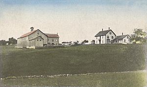
Meredith, New Hampshire facts for kids
Quick facts for kids
Meredith, New Hampshire
|
||
|---|---|---|
|
Town
|
||
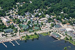
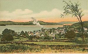
Bird's-eye view of Meredith village
|
||
|
||
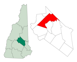
Location in Belknap County, New Hampshire
|
||
| Country | United States | |
| State | New Hampshire | |
| County | Belknap | |
| Incorporated | 1768 | |
| Villages |
|
|
| Area | ||
| • Total | 54.6 sq mi (141.3 km2) | |
| • Land | 40.1 sq mi (103.8 km2) | |
| • Water | 14.5 sq mi (37.5 km2) 26.56% | |
| Elevation | 508 ft (155 m) | |
| Population
(2020)
|
||
| • Total | 6,662 | |
| • Density | 166/sq mi (64.2/km2) | |
| Time zone | UTC−5 (Eastern) | |
| • Summer (DST) | UTC−4 (Eastern) | |
| ZIP Code |
03253
|
|
| Area code(s) | 603 | |
| FIPS code | 33-47140 | |
| GNIS feature ID | 0873662 | |
Meredith is a town in Belknap County, New Hampshire, United States. It's located in the state's beautiful Lakes Region. Meredith is a popular resort town, especially in the summer.
In 2020, about 6,662 people lived here. Meredith Village is the main part of town. It sits right on the shores of Lake Winnipesaukee. Many other large lakes are also in or near Meredith. You can find the Stonedam Island Natural Area here. The Winnipesaukee Scenic Railroad also runs through town. Meredith is also a stop for the famous MS Mount Washington boat.
Meredith Village is where most people live. It's where two main roads, U.S. Route 3 and New Hampshire Route 25, meet. This area is at the top of Meredith Bay on Lake Winnipesaukee.
Contents
History of Meredith
Meredith was first called "Palmer's Town." This was to honor Samuel Palmer. He was a teacher who helped map out the land around Lake Winnipesaukee. In 1748, it was one of the first towns to get an official charter. Many early settlers came from Salem, Massachusetts. Because of this, Palmer's Town was renamed "New Salem."
The town was settled in 1766 by Jacob Eaton and Colonel Ebenezer Smith. In 1768, Governor John Wentworth officially renamed it Meredith. The name came from Sir William Meredith, 3rd Baronet. He was a member of the British Parliament. He was known for being against taxing the American colonies.
Early farmers in Meredith grew crops like corn, wheat, rye, and potatoes. However, the area became famous for its apple orchards.
In 1795, John Jenness bought the rights to Measly Pond Brook. This brook flowed from Lake Waukewan into Lake Winnipesaukee. He used the water power to run a gristmill (for grinding grain) and a sawmill in Meredith Village.
Later, in 1800, John Bond Swasey inherited a farm in Meredith Village. He bought more land and mills around the brook. Between 1816 and 1818, Swasey built a long canal. This canal redirected water from Lake Waukewan. It created a powerful waterfall at what is now the Mill Falls Marketplace. This new waterfall powered many mills. These included sawmills, gristmills, and cotton mills. In 1895, it even powered the Meredith Electric Light Company.
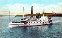
By 1859, Meredith Village had many businesses. These included a sawmill, gristmill, and a blacksmith shop. Meredith Center, another village, also had mills. In March 1849, the Boston, Concord & Montreal Railroad arrived. This made Meredith a popular summer resort. People also came by steamboat from Alton Bay. The most famous steamboat was the original SS Mount Washington. It started sailing in 1872. Today, Meredith is still a very popular place for tourists.
In 1974, the Swasey family gave land to the town. This land became Swasey Park on Lake Waukewan. It's near where the canal begins.
Geography of Meredith
Meredith covers about 141.3 square kilometers (54.6 square miles). A large part of this area, about 37.5 square kilometers (14.5 square miles), is water. The highest point in Meredith is Leavitt Mountain. It stands about 431 meters (1,414 feet) above sea level.
Meredith Village is the main business area. It's located between Meredith Bay, which is part of Lake Winnipesaukee, and Lake Waukewan. Another village, Meredith Center, is closer to the middle of the town. It's near Lake Wickwas. Meredith Center is much quieter than Meredith Village. It's close to many protected state forests and wildlife areas.
Major roads like U.S. Route 3, New Hampshire Route 25, New Hampshire Route 104, and New Hampshire Route 106 pass through Meredith. The town shares borders with several other towns. These include Sanbornton to the southwest and Center Harbor to the north.
Meredith is known for its many large lakes. About half of its border with Laconia is along Lake Winnisquam. The northern part of town is a peninsula called Meredith Neck. This separates Meredith Bay from the main part of Lake Winnipesaukee. This gives Meredith a very long coastline. Bear Island and Stonedam Island are also part of Meredith. Many smaller islands are here too. Other lakes in town include Wickwas Lake and Pemigewasset Lake. Lake Waukewan is on the western edge of Meredith Village.
Neighboring Towns
- Center Harbor (north)
- Moultonborough (northeast)
- Gilford (southeast)
- Laconia (south)
- Sanbornton (southwest)
- New Hampton (west)
Population of Meredith
Meredith has grown quite a bit over the years. In 1790, there were 881 people living here. By 1850, the population was 3,521. In 2010, about 6,241 people lived in Meredith. Most residents are White. A small percentage are from other racial backgrounds. About 1.1% of the population is Hispanic or Latino.
In 2010, there were 2,708 households in Meredith. About 25.5% of these households had children under 18. The average household had 2.27 people. The median age of people in Meredith was 48.7 years. This means half the people were older than 48.7 and half were younger.
Education in Meredith
Meredith has good schools for its young people. Inter-Lakes Middle High School serves students from Meredith. It also welcomes students from the nearby town of Center Harbor. The high school has the Inter-Lakes Community Auditorium. This is a special place where the Summer Theatre in Meredith Village performs every summer. Inter-Lakes Elementary School is for younger children. Students from Sandwich also attend the high school.
Notable People from Meredith
Many interesting people have connections to Meredith:
- Bradford Anderson (born 1979), an actor.
- Charles A. Busiel (1842–1901), a manufacturer and former governor of New Hampshire.
- Joseph Libbey Folsom (1817–1855), an army officer and real estate investor.
- George G. Fogg (1813–1881), a U.S. senator and diplomat.
- Dudley Leavitt (1772–1851), a publisher.
- Bob Montana (1920–1975), the illustrator who drew the famous Archie Comics.
- George Orton (1873–1958), a Canadian runner who won an Olympic gold medal.
- Annalee Thorndike (1915–2002), a well-known doll designer.
Fun Places to Visit in Meredith
Meredith has many cool places to explore:
- Museums
- Meredith Children's Museum: A great place for younger kids to learn and play.
- Meredith Historical Society & Museum: Learn about the town's past.
- Theatres
- The Summer Theatre in Meredith Village: Enjoy live performances during the summer.
- The Winnipesaukee Playhouse: This theatre moved to Meredith in 2013. It offers many different shows.
- Music
- Lakes Region Symphony Orchestra: Enjoy beautiful orchestral music.
- The Sweetbloods: Another musical group to check out.
- Islands
- Bear Island: A large island on Lake Winnipesaukee.
- Pine Island: Another island to explore.
- Places to Eat
- Hart's Turkey Farm: A famous restaurant known for its turkey dishes.
- Giuseppe's: A popular spot for Italian food.
See also
 In Spanish: Meredith (Nuevo Hampshire) para niños
 | Mary Eliza Mahoney |
 | Susie King Taylor |
 | Ida Gray |
 | Eliza Ann Grier |


