Meriwether County, Georgia facts for kids
Quick facts for kids
Meriwether County
|
|||
|---|---|---|---|

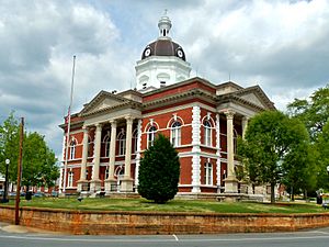
Meriwether County Courthouse in Greenville
|
|||
|
|||

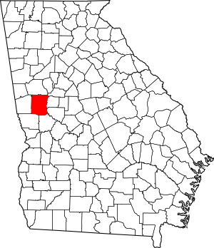
Location within the U.S. state of Georgia
|
|||
 Georgia's location within the U.S. |
|||
| Country | |||
| State | |||
| Founded | 1827 | ||
| Named for | David Meriwether | ||
| Seat | Greenville | ||
| Largest city | Manchester | ||
| Area | |||
| • Total | 505 sq mi (1,310 km2) | ||
| • Land | 501 sq mi (1,300 km2) | ||
| • Water | 4.2 sq mi (11 km2) 0.8%% | ||
| Population
(2020)
|
|||
| • Total | 20,613 | ||
| Time zone | UTC−5 (Eastern) | ||
| • Summer (DST) | UTC−4 (EDT) | ||
| Congressional district | 3rd | ||
Meriwether County is a county located in the west-central part of the U.S. state of Georgia. In 2020, about 20,613 people lived here.
The main town, or county seat, is Greenville. This is where the Meriwether County Courthouse is located. The county was created on December 14, 1827. It was the 73rd county formed in Georgia.
Meriwether County was named after David Meriwether. He was a general in the American Revolutionary War, which was when the United States fought for its independence. He also served as a member of Congress for Georgia, helping to make laws for the country.
This county is also part of the larger Atlanta-Sandy Springs-Roswell MSA. This means it is part of a big region that includes Atlanta and its surrounding cities and towns.
Contents
Exploring Meriwether County's Landscape
Meriwether County covers a total area of about 505 square miles. Most of this area, around 501 square miles, is land. The remaining 4.2 square miles, which is less than 1%, is water.
The county is found in the Piedmont region of Georgia. The Piedmont is an area of rolling hills located between the mountains and the coastal plains. You can find parts of the Pine Mountain Range in the southern areas of the county. These mountains are close to the towns of Warm Springs and Manchester.
The eastern two-thirds of Meriwether County is part of the Upper Flint River area. The western third of the county is in the Middle Chattahoochee River-Lake Harding area. Both of these rivers are important parts of the larger ACF River Basin.
Main Roads and Travel Routes
Many important roads pass through Meriwether County. These roads help people travel around the county and to other parts of Georgia.
 Interstate 85
 U.S. Route 27 Alternate
 State Route 18
 State Route 41
 State Route 54
 State Route 54 Spur
 State Route 74
 State Route 85
 State Route 85 Alternate
 State Route 85 Spur
 State Route 100
 State Route 109
 State Route 109 Spur
 State Route 173
 State Route 190
 State Route 194
 State Route 362
 State Route 403 (This is the official number for I-85, but it's not usually shown on signs.)
Neighboring Counties of Meriwether
Meriwether County shares its borders with several other counties in Georgia. Knowing its neighbors helps us understand its location better.
- Coweta County (to the north)
- Spalding County (to the northeast)
- Pike County (to the east)
- Upson County (to the southeast)
- Talbot County (to the south)
- Harris County (to the southwest)
- Troup County (to the west)
Towns and Communities
Meriwether County has several towns and communities where people live and work.
Cities in Meriwether County
- Greenville (This is the county seat, where the main government offices are.)
- Luthersville
- Manchester
- Warm Springs
- Woodbury
Towns in Meriwether County
Unincorporated Community
- Alvaton (This is a community that is not officially part of a city or town.)
Population and People
The population of Meriwether County has changed over many years. Here's a look at how many people have lived there during different census counts.
| Historical population | |||
|---|---|---|---|
| Census | Pop. | %± | |
| 1830 | 4,422 | — | |
| 1840 | 14,132 | 219.6% | |
| 1850 | 16,476 | 16.6% | |
| 1860 | 15,330 | −7.0% | |
| 1870 | 13,756 | −10.3% | |
| 1880 | 17,651 | 28.3% | |
| 1890 | 20,740 | 17.5% | |
| 1900 | 23,339 | 12.5% | |
| 1910 | 25,180 | 7.9% | |
| 1920 | 26,167 | 3.9% | |
| 1930 | 22,437 | −14.3% | |
| 1940 | 22,055 | −1.7% | |
| 1950 | 21,055 | −4.5% | |
| 1960 | 19,756 | −6.2% | |
| 1970 | 19,461 | −1.5% | |
| 1980 | 21,229 | 9.1% | |
| 1990 | 22,411 | 5.6% | |
| 2000 | 22,534 | 0.5% | |
| 2010 | 21,992 | −2.4% | |
| 2020 | 20,613 | −6.3% | |
| 2023 (est.) | 20,931 | −4.8% | |
| U.S. Decennial Census 1790-1880 1890-1910 1920-1930 1930-1940 1940-1950 1960-1980 1980-2000 2010 2020 |
|||
In 2020, the census showed that 20,613 people lived in Meriwether County. There were 8,051 households, which are groups of people living together in homes. Also, there were 5,504 families.
Here's a breakdown of the different groups of people living in Meriwether County in 2020:
| Race | Number of People | Percentage |
|---|---|---|
| White (not Hispanic or Latino) | 12,084 | 58.62% |
| Black or African American (not Hispanic or Latino) | 7,273 | 35.28% |
| Native American | 64 | 0.31% |
| Asian | 78 | 0.38% |
| Pacific Islander | 6 | 0.03% |
| Other/Mixed (people of two or more races) | 633 | 3.07% |
| Hispanic or Latino | 475 | 2.3% |
Local News and Media
The people of Meriwether County get their local news from a newspaper called the Meriwether Vindicator. This newspaper helps keep everyone informed about what's happening in their community.
See also
 In Spanish: Condado de Meriwether para niños
 | William L. Dawson |
 | W. E. B. Du Bois |
 | Harry Belafonte |


