Mississinawa Moraine facts for kids
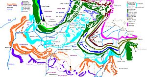
The Mississinawa Moraine is a long, low ridge of hills and rocks left behind by ancient glaciers. Think of it like a giant bulldozer pushing dirt and rocks as it moves! This moraine stretches across parts of Ohio, Indiana, and Michigan. It starts in Ohio, near Lima, then curves south past Grand Lake St. Marys and St. Marys.
From there, it heads towards Fort Recovery, Ohio and then follows the Mississinewa River northwest. It eventually meets the Wabash River near Wabash, Indiana. The moraine then turns northeast, joining up with the Packerton Moraine near Columbia City, Indiana. It doesn't stop there! It keeps going northeast through the area where Ohio, Indiana, and Michigan meet, finally reaching Ann Arbor, Michigan, where it mixes with many other moraines.
You might see the name spelled "Mississinawa" or "Mississinewa." Both are correct! The "a" spelling is older, while the "e" spelling is more common on modern maps.
Contents
What is the Mississinawa Moraine?
The Mississinawa Moraine is a special landform created by glaciers during the last Ice Age. When huge sheets of ice, called glaciers, moved across the land, they acted like giant plows. They picked up tons of soil, rocks, and other debris. As the glaciers melted and retreated, they left all this material behind, forming ridges and hills known as moraines.
The Mississinawa Moraine is a great example of how powerful glaciers were in shaping the landscape of the Midwest!
Where Can You Find the Mississinawa Moraine?
This moraine covers a large area! From the Wabash River near Lagro, it stretches northeast through several counties in Indiana, including Wabash, Whitley, Noble, and Steuben. It then crosses into Michigan, going through Hillsdale County and Lenawee County, where it connects with the younger Wabash moraine.
There's also a southern part of the moraine. It runs southeast from the Wabash River, following the northern side of the Mississinewa River (which is how it got its name!). This part goes through Grant County, including the city of Marion, and then across Blackford County. It enters Ohio south of Fort Recovery in Mercer County.
In Ohio, it makes a big curve across northern Mercer County and eventually merges with other moraines like the St. Johns moraine in Auglaize and Shelby counties. In Hardin County, parts of the Mississinawa Moraine are known by different names, like the Broadway and Powel moraines.
What Does the Mississinawa Moraine Look Like?
The Mississinawa Moraine isn't just one single ridge; it's a system of hills!
Moraine South of the Wabash River
South of the Wabash River, the moraine system is about 5 to 6 miles (8 to 10 kilometers) wide. It often splits into two or more separate ridges. These ridges can rise quite steeply, from 20 feet (6 meters) to 75 feet (23 meters) above the flat land around them. The material that makes up the moraine here is mostly stiff clay, with only a few large rocks. The nearby flat areas are also made of this stiff clay.
Moraine North of the Wabash River
North of Lagro, the moraine is about 3 to 4 miles (5 to 6 kilometers) wide. As it goes northeast past Columbia City, it gets much wider, spreading out to 5 to 15 miles (8 to 24 kilometers) across! The highest point of the moraine reaches about 1,200 feet (366 meters) above sea level in Steuben County. The moraine's surface can be 150 to 300 feet (46 to 91 meters) higher than the surrounding countryside.
The Ancient Teays River Valley
Scientists have studied the ground under the Mississinawa Moraine using special tools. In Grant and Jay Counties in Indiana, they found a very old river valley that existed before the glaciers arrived. This valley is quite deep, about 300 to 350 feet (91 to 107 meters) below the surface! It's now filled with sand and gravel left by the glaciers. This ancient valley might be connected to the famous Teays River, a huge river that flowed across North America millions of years ago, long before the Ice Age.
Related Moraines: The Kalamazoo System
The Mississinawa Moraine is part of a larger network of glacial features. One important related system is the Kalamazoo Morainic System. This system connects the areas shaped by glaciers from the Michigan basin and the Huron-Erie basins. Much of its southern part has been changed by large areas of sand and gravel washed out from the melting glaciers. You can see it best in western Jackson County. The Kalamazoo moraine merges with other moraines near Spring Arbor, about 10 miles (16 kilometers) west of Jackson.


