Mont Ventoux facts for kids
Quick facts for kids Mont Ventoux |
|
|---|---|
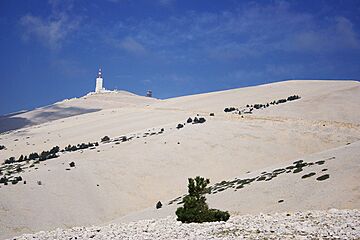
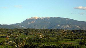
South side of the summit of Mont Ventoux
|
|
| Highest point | |
| Elevation | 1,910 m (6,270 ft) |
| Prominence | 1,148 m (3,766 ft) |
| Geography | |
| Parent range | periphery of the Alps |
| Climbing | |
| First ascent | Prior to Jean Buridan; probably ancient |
| Easiest route | Hike |
| Mont Ventoux | |
|---|---|
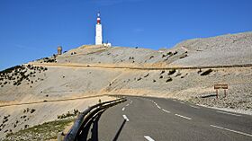
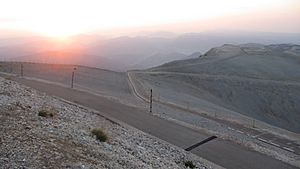
North side of the summit of Mont Ventoux
|
|
| Elevation | 1,910 m (6,266 ft) |
| Traversed by | road |
| Location | |
| Range | Free-standing on the western periphery of the Alps |
| Coordinates | 44°10′28″N 5°16′44″E / 44.17444°N 5.27889°E |
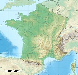
Mont Ventoux is a famous mountain in southern France. It is located in the Provence region. This mountain stands about 20 kilometers (12 miles) northeast of Carpentras.
At 1,910 meters (6,266 feet) high, it is the tallest mountain in its area. People have given it nicknames like "Beast of Provence" and "The Bald Mountain." It is very well known because it is often part of the Tour de France cycling race. In 2009, it was a key part of the race, helping Alberto Contador win the yellow jersey.
The name "Ventoux" means "windy" in French. This mountain lives up to its name! Winds can be very strong at the top, especially the mistral wind. Wind speeds as high as 320 kilometers per hour (200 mph) have been recorded. The wind blows faster than 90 kilometers per hour (56 mph) for 240 days a year. Because of these strong winds, the road over the mountain is often closed. There is a spot called col des tempêtes (storm pass) near the top, which is famous for its powerful winds.
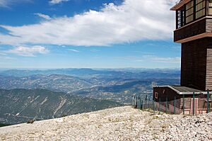
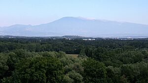
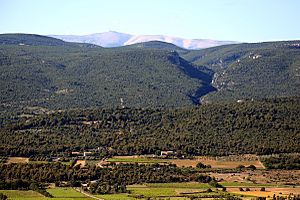
Mont Ventoux is part of the Alps mountains. However, it stands alone, without other tall mountains nearby. This makes it look very grand. The very top of the mountain is made of bare limestone. There are no trees or plants there. From far away, this makes the peak look like it's covered in snow all year. But it only has real snow from December to April. Its isolated position means you can see it from a long distance on a clear day.
| Top - 0-9 A B C D E F G H I J K L M N O P Q R S T U V W X Y Z |
History of Mont Ventoux
People probably climbed Mont Ventoux even in ancient times. The first recorded climb was by Jean Buridan before the year 1334. He climbed it to study the weather. The famous Italian poet Petrarch also wrote about climbing the mountain in 1336. His story might be fictional.
In the 1400s, a small church was built on the summit. It was dedicated to the Holy Cross.
Later, in 1882, a weather station was built on the top of the mountain. This station is not used anymore. Plans for this observatory and a road to reach it were made in 1879.
In the 1960s, a tall telecommunications mast was built on the summit. It is about 50 meters (164 feet) high.
From 1902 to 1976, a car and motorcycle race called the Mont Ventoux Hill Climb took place on the mountain's roads.
Plants and Animals on Mont Ventoux
Mont Ventoux used to be covered in forests. But from the 1100s onwards, many trees were cut down. The wood was used to build ships for the naval port of Toulon.
Since 1860, some areas have been replanted with trees. These include hardwood trees like holm oaks and beeches. There are also coniferous trees like Atlas cedars and larches. Higher up the mountain, you can often find juniper plants.
The mountain is a special place where plants and animals from northern and southern France meet. Some types of spiders and butterflies are found only on Mont Ventoux. It is also a good place to see the short-toed eagle.
In 1990, UNESCO recognized how special the mountain's nature is. They created the Réserve de Biosphère du Mont Ventoux. This protects an area of 810 square kilometers (313 square miles) on and around the mountain.
Weather on Mont Ventoux
Mont Ventoux has a unique climate. It can get very cold in winter and warm in summer. The strong winds are a big part of its weather.
| Month | Jan | Feb | Mar | Apr | May | Jun | Jul | Aug | Sep | Oct | Nov | Dec | Year |
|---|---|---|---|---|---|---|---|---|---|---|---|---|---|
| Average high °C | 1.2 | 1.6 | 5.2 | 8.2 | 13.2 | 17.7 | 20.7 | 20.5 | 14.6 | 9.9 | 4.6 | 2.0 | |
| Average low °C | −2.6 | −3.1 | −0.6 | 1.7 | 6.1 | 9.7 | 12.0 | 12.3 | 8.0 | 5.2 | 0.8 | −1.8 | |
| Average precipitation mm | 130.9 | 84.9 | 82.5 | 125.7 | 112.3 | 76.4 | 43.7 | 59.5 | 138.8 | 169.2 | 177.2 | 115.9 |
Cycling on Mont Ventoux
Mont Ventoux is very popular for road bicycle racing. There are three main ways to cycle up the mountain.
- South from Bédoin: This is the hardest way. It climbs 1,617 meters (5,305 feet) over 21.8 kilometers (13.5 miles). The road goes up steeply, with an average slope of 7.43%. The last 16 kilometers (10 miles) are especially tough, with an average slope of 8.9%. For comparison, the famous Alpe d'Huez climb is about 13.8 kilometers (8.6 miles) at 7.9%. Strong winds can make the last few kilometers even harder. It takes trained amateur riders 1.5 to 2.5 hours to climb this way. Professional riders can do it in 60 to 75 minutes. The fastest time recorded is 55 minutes and 51 seconds by Iban Mayo in 2004.
- Northwest from Malaucène: This route climbs 1,570 meters (5,151 feet) over 21.5 kilometers (13.4 miles). It is about as hard as the Bédoin route but offers more shelter from the wind.
- East from Sault: This is the easiest way. It climbs 1,210 meters (3,970 feet) over 26 kilometers (16 miles). After a place called Chalet Reynard, this route joins the Bédoin route for the final, bare part of the climb. The average slope is 4.4%.
Every year, amateur cyclists try to climb the mountain as many times as possible in 24 hours. These events are called the Ventoux Masterseries and "Les Cinglés du Mont Ventoux." In 2006, Jean-Pascal Roux set a record by climbing it eleven times from Bédoin in 24 hours.
Mont Ventoux in the Tour de France

Mont Ventoux is known for being one of the most difficult climbs in the Tour de France bicycle race. The race has gone up the mountain eighteen times since 1951. Most often, the cyclists climb from Bédoin. Because of the exciting races held here, it attracts cyclists from all over the world.
In 1970, Eddy Merckx pushed himself to the limit to win the stage. He needed oxygen afterward but recovered and went on to win the entire Tour de France. In 1994, Eros Poli, who was not known for climbing, got a big lead early in the stage. He was the first to reach the top of Ventoux and won the stage, even though he lost a lot of his lead on the climb.
Tour de France Stage Finishes
The Tour de France race has finished at the top of Mont Ventoux ten times. The finish line is usually at 1,910 meters (6,266 feet). However, in some years (1965, 1967, 1972, and 1974), the finish was a bit lower at 1,895 meters (6,217 feet).
Three riders have won a stage on Mont Ventoux and then gone on to win the whole Tour de France. These are Charly Gaul (1958), Eddy Merckx (1970), and Chris Froome (2013). Merckx and Froome were already leading the race when they won on Ventoux. Gaul took the overall lead a few stages later.
In 2008, it was announced that the Tour de France would return to Mont Ventoux in 2009 after seven years. This was unusual because the climb happened on the second-to-last day of the race. It was also featured in the 100th Tour de France in 2013.
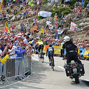
In 2016, the stage to Mont Ventoux was made shorter by 6 kilometers (3.7 miles). This was because of strong winds expected at the summit. The stage then finished at Chalet Reynard. In this race, Chris Froome had a crash involving a motorcycle. His bike was damaged, and he had to run about 100 meters (328 feet) up the mountain until he could get a new bike.
| Year | Stage | Start of stage | Distance (km) | Category | Stage winner | General classification leader | Tour de France winner |
|---|---|---|---|---|---|---|---|
| 1958 | 18 | Bédoin | 21.5 (ITT) | 1 | |||
| 1965 | 14 | Montpellier | 173 | 1 | |||
| 1970 | 14 | Gap | 170 | 1 | |||
| 1972 | 11 | Carnon-Plage | 207 | 1 | |||
| 1987 | 18 | Carpentras | 36.5 (ITT) | HC | |||
| 2000 | 12 | Carpentras | 149 | HC | |||
| 2002 | 14 | Lodève | 221 | HC | |||
| 2009 | 20 | Montélimar | 167 | HC | |||
| 2013 | 15 | Givors | 242.5 | HC | |||
| 2016 | 12 | Montpellier | 178 | HC |
Note: Lance Armstrong was stripped of his Tour de France titles from 1999 to 2005 due to doping. So, those years have no official winner.
Other Tour de France Appearances
The race has also crossed the summit of Mont Ventoux eight other times without finishing there.
| Year | Stage | Category | Start | Finish | Leader at the summit |
|---|---|---|---|---|---|
| 1951 | 18 | 1 | Montpellier | Avignon | |
| 1952 | 14 | 1 | Aix-en-Provence | Avignon | |
| 1955 | 11 | 1 | Marseille | Avignon | |
| 1967 | 13 | 1 | Marseille | Carpentras | |
| 1974 | 12 | 1 | Savines-le-Lac | Orange | |
| 1994 | 15 | HC | Montpellier | Carpentras | |
| 2021 | 11 | 1 | Sorgues | Malaucène | |
| HC |
In 1951, cyclists approached the summit from Malaucène. In 2021, the first climb was from Sault, and the second was from Bédoin. In all other years, the climb was from Bédoin.
Climbing from Bédoin: A Challenge
The bike climb from Bédoin to Mont Ventoux is one of the hardest in professional cycling. The average slope for the whole climb is about 7.43%. This is based on a horizontal distance of 21.765 kilometers (13.5 miles) and a climb of 1,617 meters (5,305 feet). The actual distance ridden is 21.825 kilometers (13.56 miles).
Here are the average slopes for each kilometer of the climb:
| Kilometer | Average slope | Kilometer | Average slope |
|---|---|---|---|
| 1 | 1.9% | 12 | 10.1% |
| 2 | 2.8% | 13 | 9.2% |
| 3 | 3.8% | 14 | 9.4% |
| 4 | 5.8% | 15 | 8.8% |
| 5 | 5.6% | 16 | 6.9% |
| 6 | 3.1% | 17 | 6.6% |
| 7 | 8.6% | 18 | 6.8% |
| 8 | 9.4% | 19 | 7.4% |
| 9 | 10.5% | 20 | 8.3% |
| 10 | 10.1% | 21 | 9.1% |
| 11 | 9.3% | 22 | 10.0% |
Transcontinental Race
Mont Ventoux was the first checkpoint in the 2015 Transcontinental Race. This is a very long bicycle race across Europe where riders do not stop and get no outside help.
Skiing on Mont Ventoux
There are two small ski areas on the mountain. "Mont Serein" is on the north side, and "Chalet Reynard" is on the south. Strong winds and the mountain's height often limit how long the ski season lasts. The northern slope can be very icy. People in the area have a saying: Qui skie au Ventoux, skie partout (If you can ski Ventoux, you can ski anywhere). This means if you can handle the conditions on Mont Ventoux, you can ski well anywhere.
See also
 In Spanish: Mont Ventoux para niños
- List of highest paved roads in Europe
- List of mountain passes
 | Sharif Bey |
 | Hale Woodruff |
 | Richmond Barthé |
 | Purvis Young |


