Neighborhoods of Richmond, Virginia facts for kids
The Greater Richmond, Virginia area has many different neighborhoods and areas. It's like a big puzzle made of many unique pieces!
Contents
Richmond's Big Areas: North, South, East, and West
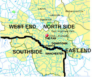
The Richmond area is much bigger than just the city itself. It includes parts of nearby counties too. People often talk about Richmond by dividing it into four main parts, like the directions on a compass: the North Side, Southside, East End, and West End.
These areas don't have exact borders because there isn't one big group that manages the whole Richmond region. The James River also helps define these areas. It separates Henrico County (on the north side) from Chesterfield County (on the south side). For a long time, the James River also separated the City of Richmond from the City of Manchester until they joined together in 1910. A big part of the river in Richmond is now a cool park system called the James River Park System.
It's harder to draw clear lines between these areas the further you get from the city. This is especially true north of the James River, where the East, North, and West End areas all blend together. Sometimes, even parts of Hanover County are considered part of the Richmond area, even though it's a bit further away. Some towns like Mechanicsville, Midlothian, or Short Pump might be seen as separate from Richmond.
Downtown Richmond: The Heart of the City
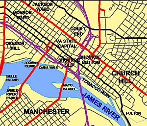
Downtown Richmond is full of history and different kinds of places.
Court End: Where History Lives
Court End is one of Richmond's oldest neighborhoods. It has some of the city's most important and historic homes. This area is just north of the Capitol Building. It's called "Court End" because the Virginia Supreme Court is located nearby. Many important people in Richmond's past lived here because it was so close to the government buildings. This small area is known for its beautiful and unique old buildings.
Jackson Ward: A Hub of Culture
Jackson Ward is a historic neighborhood for Black people. It was once called the "Harlem of the South" because it was a lively center for Black businesses and entertainment. Famous artists like Duke Ellington, Ella Fitzgerald, and James Brown used to visit here.
Jackson Ward was also home to Maggie L. Walker, who was the first woman in the United States to start and lead a bank! Her house is now a special U.S. National Historic Site. The Shockoe Hill African Burying Ground is also in Jackson Ward. It's probably the largest burial ground for enslaved and free Black people in the U.S. It's a very important historical place. The Hippodrome Theater is another famous spot in Jackson Ward.
In the 1950s, when the Interstate highway system was built, Jackson Ward was split in half by a highway. This changed the neighborhood a lot. In the early 2000s, the Greater Richmond Convention Center was built at the edge of Jackson Ward.
Monroe Ward: A Defined Area
Monroe Ward is a neighborhood with clear boundaries. It's located between Belvidere Street (east), Broad Street (south), Franklin Street (north), and 14th Street (west). It's just north of the Midtown neighborhood.
Midtown: South of Monroe Ward
Midtown is south of Monroe Ward. Its boundaries are Franklin Street (south) to West Canal Street, and Belvidere Street (east) to 7th Street.
The River District: Along the Canal
In 1999, Richmond finished its "canal walk" project. This fixed up a part of the old Haxall Canal and the James River and Kanawha Canal. This area was made into a place for tourists to visit. The area around the Canal Walk was then called "The River District."
The exact borders of the River District aren't set in stone. It includes some businesses that people might think are part of other areas, like Shockoe Bottom.
Shockoe Slip: Old Warehouses, New Life
Shockoe Slip is a group of old tobacco warehouses that have been turned into shops, restaurants, and offices. The word "slip" refers to where canal boats used to load and unload goods nearby. Shockoe Slip became a popular area for businesses and fun in the 1970s. Its general boundaries are 14th Street, Main Street, Canal Street, and 12th Street.
East End: A Mix of Neighborhoods
The East End of Richmond, Virginia is actually many different neighborhoods put together. Inside the city and in Henrico County, it's generally the area north of the James River and east of the old railroad line.
Some neighborhoods in the city's East End include Church Hill, Fairmount, Union Hill, Fulton, Fulton Hill, and Mosby Court. The term "East End" also includes much of eastern Henrico County and part of Hanover County.
Church Hill: Historic Speeches and Parks
The historic area of Church Hill is where the city of Richmond first began. This is where Patrick Henry gave his famous "Give me liberty or give me death" speech at St. John's Church. Chimborazo Park was once the site of the biggest hospital during the American Civil War. Church Hill is special because it's one of the largest neighborhoods from the 1800s that is still mostly preserved today. It has many beautiful old buildings.
Shockoe Bottom: Rebuilding After Floods
Shockoe Bottom is just east of downtown, along the James River. It became a popular spot for nightlife, dining, and entertainment in the late 1900s. After many years of floods from the James River, a big flood wall was built in 1995, which helped the area grow. However, in 2004, Hurricane Gaston caused a different kind of flood from a local creek, which damaged many businesses and buildings.
Tobacco Row: From Factories to Homes
Just east of Shockoe Bottom, Tobacco Row is a collection of old tobacco warehouses and factories. They are next to the James River and Kanawha Canal near the James River. Starting in the 1700s, many tobacco farmers and sellers had their buildings here. Large brick buildings were built to protect the tobacco from fires.
During the American Civil War (1861–1865), Tobacco Row was home to famous prisons like Libby Prison and Castle Thunder, which were run by the Confederate government.
The tobacco companies left the area by the late 1980s. Many of the old warehouses were then updated and turned into apartments, condos, offices, and shops.
Union Hill: A Historic View
Union Hill is one of Richmond's oldest and most historic neighborhoods. It's on a high hill above Shockoe Bottom. The houses here are a mix of styles, and the streets are sometimes narrow and winding. Homes along Jefferson Park have a great view of downtown Richmond. Union Hill is bordered by Jefferson Avenue (south), Venable Street (north), 25th Street (east), and Mosby (west). The name "Union Hill" probably came about in 1817 because several small hills were joined together over time.
Near West and West End: Diverse Living
This section looks at neighborhoods that have been considered part of Richmond's West End.
Byrd Park: Lakes and Homes
The Byrd Park neighborhood was planned in the late 1910s. It's a residential area now in the central part of the city. It's bordered by Byrd Park and Maymont Park to the south. The neighborhood is known for its three lakes: Boat, Swan, and Shields. Homes here include row houses from the 1920s and various styles from the 1930s and 1940s. Some large mansions are found along Westover Road.
Carver: A Reborn Community
The Carver neighborhood, also called Sheep Hill, is north of Broad Street (Richmond, Virginia). It was first settled by Jewish and German workers. In the early 1900s, it became a busy Black community. Later, major highways like Interstate 95 cut through the area, and many houses became empty. By the 1950s, Carver was seen as a "dangerous" neighborhood.
Today, Carver has new life! Old houses are being fixed up, and new ones are being built. Virginia Commonwealth University has also expanded into the area, bringing students and new energy. Now, Carver is a diverse mix of students, young families, and older residents.
Carytown/Museum District: Shops and Culture
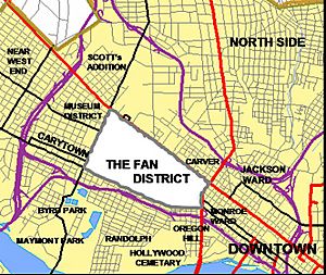
Carytown is a neighborhood with homes and many unique shops, clothing stores, cafes, and restaurants along Cary Street. The Byrd Theatre is here, a historic movie palace from the 1920s. It shows older movies and has a special organ that plays music.
The Museum District is just west of the Fan district. It's home to the Virginia Museum of Fine Arts and the Virginia Museum of History & Culture. The buildings here are mostly from the 1920s, but you can also find other styles. Most houses are connected or semi-detached.
The Fan District: A Unique Shape
The Fan District is a residential neighborhood where Virginia Commonwealth University is located. It's named for the fan-shaped pattern of its streets. The buildings here are mostly from the late 1800s and early 1900s. It's just west of Downtown.
Uptown: VCU's Home Base
Also known as the Lower Fan area, Uptown is popular with VCU students and has many university buildings. It's generally located between Meadow Street (east) to Belvidere, and West Canal Street (north) to Broad Street.
Newtowne West: Revitalization in Progress
Newtowne West is west of Carver. It's a residential neighborhood north of Broad Street. It started as a working-class Black neighborhood in the 1890s. It became more self-sufficient in the 1920s but then declined later in the 1900s. In 1999, it was chosen for a city program to help neighborhoods grow again. The historic Maggie L. Walker High School was renovated here in 2001.
Scott's Addition: From Industry to Fun
Scott's Addition Historic District is a neighborhood that used to be industrial. Now, it has been redeveloped into a busy area with many modern restaurants and bars. It's bordered by Broad Street (south), Boulevard (east), I-95/I-64 (north), and I-195 (west).
Northside: Green Spaces and Colleges
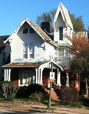
Richmond's North Side has many different neighborhoods, like Bellevue, Ginter Park, and Highland Park. The houses here have many different styles, including Arts and Crafts Bungalows and Victorian homes. The North Side is home to Virginia Union University and Union Presbyterian Seminary. It also has fun places like the Lewis Ginter Botanical Garden, Bryan Park, and Richmond Raceway.
The term "North Side" also includes much of central Henrico County, like Lakeside.
Southside: Across the James River
Manchester: A City of Its Own
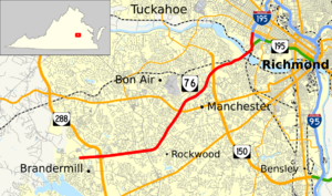
Manchester is an industrial and residential area directly south of downtown Richmond, across the James River. For over 200 years, Manchester was its own separate town and then an independent city. It was successful because of its mills and docks. Coal from the Midlothian area was brought here on the Chesterfield Railroad, which was the first railroad in Virginia, starting in 1831. The City of Manchester joined with Richmond in 1910.
The old train station in Manchester now holds a museum for railway history.
Forest Hill: A Park and Historic Homes
The Forest Hill neighborhood is along the southern banks of the James River. It was one of the first neighborhoods built around a trolley car line. The trolley line ended at Forest Hill Park, which used to have an amusement park and swimming lakes.
This neighborhood was home to Frederick William Sievers, a sculptor who created famous statues like the ones of Matthew Fontaine Maury and Stonewall Jackson on Monument Avenue.
Westover Hills: Established and Diverse
Westover Hills is an established neighborhood directly south of the James River. Most of the homes here were built between 1920 and 1940. They come in many different styles, like Cape Cods, Spanish Colonial, and Tudor Revival.
Many homes have large yards and feel like they are in the suburbs. Some homes overlook the James River or Forest Hill Park. The neighborhood has well-known restaurants, businesses, and churches.
Stratford Hills and Southampton: Annexed by the City
Stratford Hills started as part of Chesterfield County but became part of the City of Richmond in the 1970s. Homes here are mostly 1950s-style ranchers and split-levels. There are also some larger, beautiful homes along Riverside Drive. The neighborhood is bordered by Forest Hill Avenue (south) and the James River (north). The Pony Pasture and James River Park System are easy to reach from this neighborhood.
Bon Air: A Historic Suburb
Bon Air is located in Chesterfield County, just outside Richmond's city limits. It started in 1877 as a vacation spot along a train line. Over time, it grew into a year-round village and is now a suburb of Richmond. The center of Bon Air Village is a National Historic District with many Victorian buildings from the late 1800s and early 1900s.
Today, Bon Air is mostly a "bedroom community," meaning people live there and often commute to work elsewhere. It's surrounded by shopping centers, some of which have unique local businesses. Bon Air is about a 10-minute drive from the city.
Other Southside Neighborhoods
Places like Midlothian, Brandermill, and Chester, Virginia are more closely linked to Chesterfield County, Virginia. However, they are sometimes included when people talk about the Southside of Richmond. The parts of Richmond that are within the city limits are sometimes called South Richmond.
 | William M. Jackson |
 | Juan E. Gilbert |
 | Neil deGrasse Tyson |


