
Northeast Region of Brazil facts for kids
Quick facts for kids Northeast Region |
|
| Região Nordeste | |
| Region of Brazil | |
| Country | |
|---|---|
| States | Alagoas, Bahia, Ceará, Maranhão, Paraíba, Pernambuco, Piauí, Rio Grande do Norte, Sergipe |
| Largest cities | Recife (by metro pop.), Salvador (by city proper), Fortaleza (by pop. density) |
| Highest point | Pico do Barbado |
| - location | Serra do Barbado, Chapada Diamantina, Bahia |
| - elevation | 2,033 m (6,670 ft) |
| - coordinates | 13°17′47″S 41°54′28″W / 13.29639°S 41.90778°W |
| Lowest point | Sea level |
| - elevation | 0 m (0 ft) |
| Area | 1,554,291.31 km² (600,115 sq mi) |
| Population | 56,915,936 (1 January 2016) |
| Density | 37 /km² (96 /sq mi) |
The Northeast Region of Brazil (called Região Nordeste do Brasil in Portuguese) is one of the five main areas of Brazil. The Brazilian Institute of Geography and Statistics officially defined this region in 1969.
It is the third largest region in Brazil by land size. It covers about 18% of the country's total area. It is also the second most populated region in Brazil.
Contents
Exploring the Northeast Region
The Northeast Region covers a large area of 1,554,291.31 km2 (600,115.23 sq mi). It has the longest coastline of any region in Brazil, stretching along the Atlantic Ocean.
Climate and Nature
The weather here is very hot all year round. Near the coast, it has a tropical climate, which means it's warm and humid. Further inland, the climate becomes semi-arid, meaning it's much drier. In the far west, it's semi-equatorial, which is also hot but with more rain.
The plant life is varied. You'll find desert-like plants in the dry areas. Along the coast and in the west, there are tropical forests. In the southwest, there's a type of savanna called the Cerrado, which has grasslands and scattered trees.
Where is the Northeast Region?
The Northeast Region is located between 1° 02' 30" north and 18° 20' 07" south in terms of latitude. For longitude, it's between 34° 47' 30" and 48° 45' 24" west.
It shares its borders with:
- The Atlantic Ocean to the north and east.
- The states of Minas Gerais and Espírito Santo to the south.
- The states of Pará, Tocantins, and Goiás to the west.
 |
Atlantic Ocean | |
||
| Tocantins | Atlantic Ocean | |||
| Goiás | Minas Gerais | Espírito Santo |
The two most important rivers in this region are the São Francisco and the Parnaíba rivers. Both of these rivers have many smaller streams and rivers, called tributaries, flowing into them.
High Points of the Region
The highest point in the Northeast Region is Pico do Barbado. This mountain is 2,033 m (6,670 ft) tall. It is part of the larger Serra do Barbado mountain range, which is found in the Chapada Diamantina area of Bahia state.
Here are the highest points in each state of the Northeast Region:
| State | Mountain Name | Height |
|---|---|---|
| Alagoas | Pico 844 (Serra Santa Cruz) | 844 m (2,769 ft) |
| Bahia | Pico do Barbado (Serra do Barbado) | 2,033 m (6,670 ft) |
| Ceará | Pico Serra Branca | 1,154 m (3,786 ft) |
| Maranhão | Pico 804 (Chapada das Mangabeiras) | 804 m (2,638 ft) |
| Paraíba | Pico do Jabre | 1,197 m (3,927 ft) |
| Pernambuco | Pico 1195 (Serra da Boa Vista) | 1,195 m (3,921 ft) |
| Piauí | Pico 865 (Serra Grande) | 865 m (2,838 ft) |
| Rio Grande do Norte | Pico 868 (Serra do Coqueiro) | 868 m (2,848 ft) |
| Sergipe | Pico 742 (Serra Negra) | 742 m (2,434 ft) |
States of the Northeast Region
The Northeast Region is made up of nine different states. These states are: Alagoas, Bahia, Ceará, Maranhão, Paraíba, Pernambuco, Piauí, Rio Grande do Norte, and Sergipe.
Here is a table showing information about each state:
| Code | State | Capital City | Number of Municipalities | Population (2016) |
Area (km2) |
People per km2 |
|---|---|---|---|---|---|---|
| BR-AL | Maceió | 102 | 3,358,963 | 27,848.16 | 120.6 | |
| BR-BA | Salvador | 63 | 15,276,566 | 564,732.64 | 27.1 | |
| BR-CE | Fortaleza | 184 | 8,963,663 | 148,887.63 | 60.2 | |
| BR-MA | São Luís | 217 | 6,954,036 | 331,936.96 | 20.9 | |
| BR-PB | João Pessoa | 223 | 3,999,415 | 56,468.43 | 70.8 | |
| BR-PE | Recife | 185 | 9,410,336 | 98,076.00 | 95.9 | |
| BR-PI | Teresina | 224 | 3,212,180 | 251,611.93 | 12.8 | |
| BR-RN | Natal | 167 | 3,474,998 | 52,811.11 | 65.8 | |
| BR-SE | Aracaju | 75 | 2,265,779 | 21,918.45 | 103.4 | |
| Total | 1,440 | 56,915,936 | 1,554,291.31 | 36.6 | ||
Population and Cities
As of July 1, 2016, the Northeast Region had a population of 56,915,936 people. This means there were about 36.6 people living in each square kilometer.
Here are some of the most important and largest cities in the Northeast Region:
| Rank | City Name | State | Population | Rank | City Name | State | Population |
|---|---|---|---|---|---|---|---|
| 1 | Salvador | Bahia | 2,938,092 | 11 | Feira de Santana | Bahia | 622,639 |
| 2 | Fortaleza | Ceará | 2,609,716 | 12 | Campina Grande | Paraíba | 407,754 |
| 3 | Recife | Pernambuco | 1,625,583 | 13 | Olinda | Pernambuco | 390,144 |
| 4 | São Luís | Maranhão | 1,082,935 | 14 | Caucaia | Ceará | 358,164 |
| 5 | Maceió | Alagoas | 1,021,709 | 15 | Caruaru | Pernambuco | 351,686 |
| 6 | Natal | Rio Grande do Norte | 877,662 | 16 | Vitória da Conquista | Bahia | 346,069 |
| 7 | Teresina | Piauí | 847,430 | 17 | Petrolina | Pernambuco | 337,683 |
| 8 | João Pessoa | Paraíba | 801,718 | 18 | Paulista | Pernambuco | 325,590 |
| 9 | Jaboatão dos Guararapes | Pernambuco | 691,125 | 19 | Camaçari | Bahia | 292,074 |
| 10 | Aracaju | Sergipe | 641,523 | 20 | Mossoró | Rio Grande do Norte | 291,937 |
-
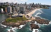
Salvador is a major city in Bahia.
-
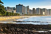
Fortaleza is a large city in Ceará.
-
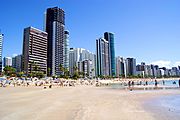
Recife is the capital of Pernambuco.
-
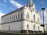
São Luís is the capital of Maranhão.
.jpg)

_-_Recife_-_Pernambuco,_Brasil.jpg)

