Ozark, Arkansas facts for kids
Quick facts for kids
Ozark, Arkansas
|
|
|---|---|

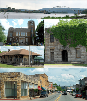
Clockwise, from top: Highway 23 bridge over the Arkansas River, historic Franklin County Jail, Ozark Courthouse Square Historic District, Ozark Depot, Franklin County Courthouse
|
|
| Motto(s):
"Where it all begins"
|
|

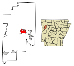
Location of Ozark in Franklin County, Arkansas.
|
|
| Country | United States |
| State | Arkansas |
| County | Franklin |
| Area | |
| • Total | 7.97 sq mi (20.66 km2) |
| • Land | 7.93 sq mi (20.54 km2) |
| • Water | 0.04 sq mi (0.11 km2) |
| Elevation | 476 ft (145 m) |
| Population
(2020)
|
|
| • Total | 3,542 |
| • Density | 446.60/sq mi (172.43/km2) |
| Time zone | UTC−06:00 (Central (CST)) |
| • Summer (DST) | UTC−05:00 (CDT) |
| ZIP Code |
72949
|
| Area code(s) | 479 |
| FIPS code | 05-52970 |
| GNIS feature ID | 2404457 |
Ozark is a city in Franklin County, Arkansas, USA. It is one of the two main cities where the county government is located. The city sits along the Arkansas River in the Arkansas River Valley. It is also on the southern edge of the beautiful Ozark Mountains.
Ozark was officially made a city in 1850. It is close to many Arkansas wineries. The city also has a bridge that crosses the Arkansas River. This bridge is useful for people traveling south. Ozark is located on Arkansas Highway 23, which is known as the Pig Trail Scenic Byway. This road is famous for its steep drops, sharp curves, and amazing mountain views.
The name Aux Arcs was given to this bend of the river by French explorers. This name was later made simpler to "Ozark."
Contents
History of Ozark
Early Native American Life
Long ago, Native Americans lived freely in this area. The Cherokee and Osage tribes were among those who called this land home. Later, French fur trappers often visited the Ozark area. They used it as an important landmark while exploring the region. These French adventurers gave the area and its rolling mountains the name Aux Arcs.
Ozark's Growth and the Trail of Tears
In 1803, this area became part of the Louisiana Purchase. Ozark then became a popular stopping and crossing point along the Arkansas River. The modern town of Ozark was started in the 1830s. An important road was built connecting Ozark to Fayetteville, Arkansas. This road followed the path of today's Pig Trail Scenic Byway. It helped connect Northwest Arkansas with the river.
Ozark also played a part in the Trail of Tears. Steamboats often stopped here when the water was low. Native Americans sometimes camped in Ozark before walking to Oklahoma. The riverfront in Ozark is a special stop on the Trail of Tears route.
Ozark During the Civil War
During the Civil War, Ozark's population grew to about 100 people. It became a base for the Confederate army after battles in 1862. In April 1863, a general led 900 men from Ozark. They went on an expedition that ended at the Battle of Fayetteville. Ozark itself saw fighting later that year and again in 1864. Many small battles happened nearby. There is a monument at the Franklin County Courthouse. It honors an officer who was killed just north of town.
Even after the war, Ozark remained a small city on the river. The name "Ozark" comes from Aux Arcs, given by early French settlers. Ozark, Arkansas, was the first community to be named "Ozark."
Geography and Location
Ozark is located in the eastern part of Franklin County. It is on the north side of the Arkansas River. The city is about 48 miles west of Russellville. It is also about 38 miles east of Fort Smith. The city limits reach north to Interstate 40. You can get to Ozark from Exits 35 and 37 on I-40.
U.S. Route 64 goes through the center of Ozark. This road provides a local east-west route that runs next to I-40. Arkansas Highway 23 goes north from Ozark. This is the Pig Trail Scenic Byway, which goes into the Ozark Mountains. To the south, Highway 23 crosses the Arkansas River. It then leads to Booneville.
Ozark has a total area of about 7.97 square miles (20.66 square kilometers). Most of this area is land. Ozark is the point where the Arkansas River is farthest north in the state of Arkansas.
Climate in Ozark
Ozark has hot, humid summers. Its winters are usually mild to cool. This type of weather is called a humid subtropical climate. On August 10, 1936, Ozark recorded the highest temperature ever in Arkansas. It was a very hot 120 degrees Fahrenheit (49 degrees Celsius).
| Climate data for Ozark, Arkansas, 1991–2020 normals, extremes 1892–present | |||||||||||||
|---|---|---|---|---|---|---|---|---|---|---|---|---|---|
| Month | Jan | Feb | Mar | Apr | May | Jun | Jul | Aug | Sep | Oct | Nov | Dec | Year |
| Record high °F (°C) | 81 (27) |
86 (30) |
94 (34) |
95 (35) |
99 (37) |
108 (42) |
116 (47) |
120 (49) |
110 (43) |
104 (40) |
87 (31) |
82 (28) |
120 (49) |
| Mean maximum °F (°C) | 69.0 (20.6) |
72.6 (22.6) |
80.6 (27.0) |
85.7 (29.8) |
90.1 (32.3) |
94.1 (34.5) |
99.2 (37.3) |
99.6 (37.6) |
94.5 (34.7) |
87.4 (30.8) |
76.3 (24.6) |
69.7 (20.9) |
101.1 (38.4) |
| Mean daily maximum °F (°C) | 48.3 (9.1) |
53.6 (12.0) |
62.3 (16.8) |
71.4 (21.9) |
78.9 (26.1) |
87.4 (30.8) |
91.9 (33.3) |
91.4 (33.0) |
84.2 (29.0) |
73.0 (22.8) |
60.6 (15.9) |
50.5 (10.3) |
71.1 (21.8) |
| Daily mean °F (°C) | 38.3 (3.5) |
42.6 (5.9) |
50.9 (10.5) |
59.5 (15.3) |
68.0 (20.0) |
76.5 (24.7) |
80.8 (27.1) |
80.1 (26.7) |
73.0 (22.8) |
61.6 (16.4) |
49.9 (9.9) |
41.0 (5.0) |
60.2 (15.7) |
| Mean daily minimum °F (°C) | 28.3 (−2.1) |
31.6 (−0.2) |
39.4 (4.1) |
47.6 (8.7) |
57.2 (14.0) |
65.6 (18.7) |
69.7 (20.9) |
68.7 (20.4) |
61.7 (16.5) |
50.2 (10.1) |
39.1 (3.9) |
31.5 (−0.3) |
49.2 (9.6) |
| Mean minimum °F (°C) | 12.9 (−10.6) |
17.0 (−8.3) |
22.6 (−5.2) |
32.7 (0.4) |
42.2 (5.7) |
55.3 (12.9) |
61.4 (16.3) |
60.0 (15.6) |
47.3 (8.5) |
33.9 (1.1) |
23.9 (−4.5) |
16.8 (−8.4) |
9.9 (−12.3) |
| Record low °F (°C) | −16 (−27) |
−15 (−26) |
4 (−16) |
22 (−6) |
32 (0) |
42 (6) |
48 (9) |
46 (8) |
32 (0) |
19 (−7) |
9 (−13) |
−8 (−22) |
−16 (−27) |
| Average precipitation inches (mm) | 3.49 (89) |
3.28 (83) |
4.82 (122) |
5.03 (128) |
5.82 (148) |
4.90 (124) |
3.52 (89) |
4.19 (106) |
3.98 (101) |
4.73 (120) |
4.65 (118) |
3.83 (97) |
52.24 (1,325) |
| Average snowfall inches (cm) | 1.9 (4.8) |
1.0 (2.5) |
0.1 (0.25) |
0.0 (0.0) |
0.0 (0.0) |
0.0 (0.0) |
0.0 (0.0) |
0.0 (0.0) |
0.0 (0.0) |
0.0 (0.0) |
0.0 (0.0) |
0.4 (1.0) |
3.4 (8.55) |
| Average precipitation days (≥ 0.01 in) | 7.4 | 7.1 | 9.4 | 8.4 | 10.9 | 8.6 | 8.4 | 7.5 | 6.3 | 7.7 | 7.7 | 7.2 | 96.6 |
| Average snowy days (≥ 0.1 in) | 0.9 | 1.0 | 0.3 | 0.0 | 0.0 | 0.0 | 0.0 | 0.0 | 0.0 | 0.0 | 0.0 | 0.4 | 2.6 |
| Source 1: NOAA (snow/snow days 1981–2010) | |||||||||||||
| Source 2: NWS/XMACIS2 | |||||||||||||
Population of Ozark
| Historical population | |||
|---|---|---|---|
| Census | Pop. | %± | |
| 1850 | 82 | — | |
| 1870 | 210 | — | |
| 1880 | 824 | 292.4% | |
| 1890 | 862 | 4.6% | |
| 1900 | 848 | −1.6% | |
| 1910 | 1,146 | 35.1% | |
| 1920 | 1,262 | 10.1% | |
| 1930 | 1,564 | 23.9% | |
| 1940 | 1,402 | −10.4% | |
| 1950 | 1,757 | 25.3% | |
| 1960 | 1,965 | 11.8% | |
| 1970 | 2,592 | 31.9% | |
| 1980 | 3,621 | 39.7% | |
| 1990 | 3,330 | −8.0% | |
| 2000 | 3,525 | 5.9% | |
| 2010 | 3,684 | 4.5% | |
| 2020 | 3,542 | −3.9% | |
| U.S. Decennial Census | |||
Ozark's Population in 2020
As of the 2020 United States census, there were 3,542 people living in Ozark. These people made up 1,539 households and 808 families.
| Race | Number | Percentage |
|---|---|---|
| White (non-Hispanic) | 3,074 | 86.79% |
| Black or African American (non-Hispanic) | 16 | 0.45% |
| Native American | 37 | 1.04% |
| Asian | 21 | 0.59% |
| Pacific Islander | 1 | 0.03% |
| Other/Mixed | 218 | 6.15% |
| Hispanic or Latino | 175 | 4.94% |
Education in Ozark
Students in Ozark attend public schools run by two different school districts:
- Ozark School District: Students here can graduate from Ozark High School.
- Mulberry–Pleasant View Bi-County School District: Students can graduate from Mulberry High School. This district includes Millsap Intermediate School (grades 5-6) and Pleasant View Junior High (grades 7-9), both in Ozark.
Ozark is also home to Arkansas Tech University–Ozark Campus. This is a two-year college campus connected to Arkansas Tech University in Russellville, Arkansas. Arkansas Tech-Ozark is a top place for career and technical education in the area. It offers many associate degrees and technical certificates. It also has general studies classes.
The campus started in 1965 as Arkansas Valley Vocational Technical School (AVVTS). In 1975, it became the first school of its kind in Arkansas to be officially recognized. In 1991, its name changed to Arkansas Valley Technical Institute (AVTI). Then, on July 1, 2003, AVTI joined with Arkansas Tech University. It became what we know today as Arkansas Tech University–Ozark Campus.
Things to Do in Ozark

Downtown Ozark has many interesting historic places. One of these is the old Missouri Pacific Depot. It is now a museum that shows many items from the city's history. You can also find colorful murals painted around the city. The main town square has antique and gift shops. In summer and fall, you can see beautiful crape myrtle shrubs blooming. There is also a park across from the courthouse.
The old Franklin County Jail looks like a medieval castle. It has a unique stone design.
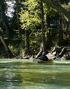
Ozark is the starting point for the Pig Trail Scenic Byway. This scenic drive is about 19 miles long. It begins 11 miles north of Ozark. This is where Highway 23 enters the Ozark National Forest. The Pig Trail takes drivers through rolling mountains. You can see waterfalls, cool rock formations, and the Mulberry River. The Mulberry River is a popular spot for kayaking and canoeing. Ozark is a great place to stop for food and rest when exploring the Pig Trail.
Ozark Lake on the Arkansas River offers many chances for fishing. Aux Arc Park is a tree-shaded park along the river. It stretches from the Ozark Lock and Dam. The park has a playground, campsites, and boat launching ramps. Close to Ozark, you can find the Mulberry River and White Rock Mountain Recreation Area. These are both in the Ozark National Forest.
Ozark is also in the middle of Arkansas Wine Country. Other nearby cities in this area include Altus, Wiederkehr Village, and Paris.
Ozark in Movies and TV
Ozark has been featured in some TV shows. In the first season of the reality TV series The Simple Life, Paris Hilton and Nicole Richie worked at the Sonic Drive-In in Ozark.
On April 17, 2007, TV host Craig Ferguson talked about Ozark on the Late Show with David Letterman. He said he stopped in "Ozark, which is a town in Arkansas," and tried catfish for the first time. He thought it was a "tasty fish." Later, on June 14, 2007, Ferguson showed a letter from Ozark's Mayor. The Mayor made Ferguson an honorary citizen of Ozark. This started a trend for Ferguson. He tried to become an honorary citizen of many US cities. He later became an official US citizen, partly because of Ozark.
On June 25, 2009, Ferguson mentioned Ozark again. He told his audience that Ozark was the place for good catfish. He called it a "lovely town." In 2010, Ferguson helped pay for a new $415,000 turf field for Ozark High School's football team.
Notable People from Ozark
- Mark H. Berry, an American politician.
- Roy Buchanan (1939–1988), a talented guitar player, was born in Ozark.
- Marshall Chrisman (born 1933), a former member of the Arkansas House of Representatives from Ozark.
- Minnie Rutherford Fuller, a farmer, broker, and leader for women's rights.
- Elizabeth Gracen, who was Miss Arkansas and Miss America in 1982.
- Theodore H. Laban, a highly honored U.S. Army Air Forces soldier.
- John Outlaw, a football coach from Ozark.
- Leslee Milam Post (born 1973), a Democratic politician who served in the Arkansas House of Representatives.
- Joe Purdy, a folk/indie music artist.
- Jesse Wells, an indie/rock music artist.
- Bill Dees, a songwriter famous for writing "Oh! Pretty Woman."
Images for kids
See also
 In Spanish: Ozark (Arkansas) para niños


