
Pearson Island facts for kids
.jpeg)
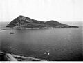
View of Pearson Island from its south end circa 1914 (State Library of South Australia PRG-280-1-12-263)
|
|

Pearson Island
Location in South Australia
|
|
| Geography | |
|---|---|
| Location | Great Australian Bight |
| Coordinates | 33°57′39″S 134°15′54″E / 33.96089°S 134.265°E |
| Area | 213 ha (530 acres) |
| Highest elevation | 238 m (781 ft) |
| Administration | |
Pearson Island is a special island in South Australia. It's part of a group called the Pearson Isles, which are themselves part of the larger Investigator Group. This island is about 63 kilometers (39 miles) southwest of Cape Finniss on the west coast of the Eyre Peninsula.
The Pearson Isles were discovered and named by explorer Matthew Flinders on February 13, 1802. Since the 1960s, these islands have been protected areas. In 2011, they became part of the Investigator Group Wilderness Protection Area. Pearson Island is famous for its unique population of Pearson Island Rock Wallabies and for being a key spot for scientific research.
Contents
Exploring Pearson Island: What It Looks Like


Pearson Island is located about 63 kilometers (39 miles) southwest of Cape Finniss. It's also about 25 kilometers (16 miles) southwest of Flinders Island. It's the biggest of the four islands that make up the Pearson Isles.
The island has one main landmass. Two smaller peaks rise from the sea, forming a curve that extends southeast. These peaks are connected by a narrow strip of rock. This curved shape creates a sheltered bay called “Anchorage Cove.” This cove is a safe place for boats and a good spot to land on the island.
The island is often thought of as three parts: the “north section,” the “middle section,” and the “south section.” There's also a rock that is always dry, located just west of the "south section."
Island Size and Tallest Points
Pearson Island covers an area of 213 hectares (526 acres). Its highest point is called “Hill 781,” which is 238 meters (781 feet) above sea level. This hill is in the southwest part of the north section. It's named after its height in feet!
Two other hills, “North Hill” and “East Hill,” are also over 200 meters (656 feet) tall. The highest point on the rest of the island is “South Hill,” which is 115 meters (377 feet) tall.
Valleys and Creeks
The north section of the island has two valleys. One valley opens onto a bay to the north called “East Cove.” The other valley opens onto a bay on the east side of the island.
These valleys are surrounded by ridges. Each valley has a natural drainage system that leads to a creek. These creeks are known as “North Creek” and “Main Creek.”
How Pearson Island Was Formed
Pearson Island and the other Pearson Isles were formed around 10,500 years ago. This happened when sea levels rose at the beginning of the Holocene period.
Geologically, Pearson Island is actually the top of a large rock formation called an inselberg. This inselberg is mostly hidden by the sea. The island's landscape shows features from its formation and from the type of granite rock it's made of. It also shows changes caused by the sea.
Rock Formations and Sea Erosion
The granite rock on the island has layers that have separated from the main rock body. These layers can be flat or curved. There are also cracks in the rock that allow moisture to get in. This causes the cracks to get bigger, breaking the rock into large blocks. These blocks can be 2 to 3 meters (6.5 to 10 feet) tall.
The sea has also shaped the island. On the west side, the sea has worn away the lower rock layers, creating a steep cliff. The east side of the island, including “Anchorage Cove,” has layers of limestone up to 6 to 9 meters (20 to 30 feet) above sea level. This suggests that the sea level was higher in the past.
The water around Pearson Island gets very deep quickly. It reaches depths greater than 50 meters (164 feet) within 500 meters (1,640 feet) of the coastline.
Plants and Animals of Pearson Island
Island Plants (Flora)
As of 1996, at least six different types of plant groups grow on Pearson Island.
Sheoak Woodlands
Parts of the island higher than 100 meters (328 feet) above sea level have woodlands of sheoak trees. These trees grow where there is shelter and good soil. The higher up you go, the denser the woodland becomes. Sheoaks can reach a height of 3 meters (10 feet) and have smaller plants growing beneath them. These include dryland tea tree, ruby saltbush, and rock fern.
Tea Tree and Paperbark Thickets
Below 100 meters (328 feet), you'll find thickets of two Melaleuca species: dryland tea tree and swamp paperbark. The dryland tea tree is the most common of the two.
A thick scrub of swamp paperbark grows along the Main Creek in the eastern valley. This area has good conditions, like salty soil and shelter from the valley. Areas closer to the coast have a heath plant cover.
Daisy-Bush and Saltbush
Where the soil is made from granite, the heath is mostly twiggy daisy-bush. Other plants like common correa and shore westringia also grow there.
In soils made from limestone, grey saltbush is common. marsh saltbush can be found in both types of soil.
Coastal Herbfields
On the thinnest, most exposed soils on top of granite rocks facing the sea, you'll find a herbfield. This area features plants like karkalla and Austral stork's bill. It's also edged with round-leaved pigface.
Island Animals (Fauna)


Many animals live on Pearson Island, including mammals, birds, and reptiles. In 1911, people saw seals, Cape Barren geese, and a large bird's nest at the top of the island. Some visitors hunted the Pearson Island rock wallaby, while others looked at the island's small lizards. Many seals and oystercatchers were also seen. Fish like Australasian snapper, Western blue groper, and rock cod were caught in the nearby waters.
Mammals on Pearson Island
As of 1996, the mammals found on the island include the Pearson Island rock-wallaby, bush rat, and a group of Australian sea lions that come to the island to have their babies. Australian sea lions have been seen on the island since the early 1900s.
Birds on Pearson Island
As of 2006, many different birds have been seen on Pearson Island. These include the Richard's pipit, wedge tailed eagle, white-faced heron, eastern reef egret, ruddy turnstone, masked woodswallow, galah, red-necked stint, Cape Barren geese, Horsfield's rufous tailed cuckoo, Australian raven, white-fronted chat, crimson chat, rockhopper penguin, Nankeen kestrel, white bellied sea eagle, welcome swallow, silver gull, Pacific gull, singing honeyeater, budgerigah, rock parrot, golden whistler, osprey, house sparrow, red-capped robin, red-tailed tropicbird, great cormorant, white-browed scrubwren, crested tern, common starling, hooded dotterel, barn owl, masked plover, and silver eye.
The island also has breeding colonies of fairy terns, little penguins, and sooty oystercatchers.
Reptiles on Pearson Island
As of 1996, the reptiles found on Pearson Island include the marbled gecko, four-toed earless skink, and peninsula dragon.
Pearson Island Rock-Wallaby: A Unique Subspecies
The Pearson Island rock-wallaby (Petrogale lateralis pearsoni) is a special type of black-footed rock-wallaby. It became isolated on Pearson Island about 10,500 years ago when sea levels rose.
Scientists first collected specimens of this wallaby in 1920. In 1922, it was described as a new species. Later, it was reclassified as a subspecies of the black-footed rock-wallaby.
Originally, these rock-wallabies lived only on the “north section” of the island. In 1960, six wallabies were accidentally released onto the “middle” and “south” sections. By 1976, these six had grown into a population of about 150. The north section had about 250 to 300 wallabies in 1975.
To help the species, groups of rock-wallabies from Pearson Island were moved to Thistle Island in 1974 and Wedge Island in 1975. In 2008, there were about 500 wallabies on Thistle Island and 200 on Wedge Island. Other wallabies were also moved to Liguanea, Price, Greenly, and Four Hummocks islands.
Little Penguin Population
Little penguins were first noted on Pearson Island in 1914 and were described as "plentiful" in 1923. In 1933, J. T. Mortlock said he saw "a good many" penguins there.
In 2006, the little penguin colony on Pearson Island was estimated to have 12,000 birds. This made it the largest single colony in South Australia! However, by 2011, the status of the colony was unknown. In 2013, a tour operator visited the island and reported that the little penguins were "missing." The South Australian Research and Development Institute (SARDI) planned a survey in 2013, but the results were not published by March 2014.
History of Pearson Island
European Discovery
Pearson Island is part of the island group first seen by Matthew Flinders on February 13, 1802. Flinders named them the Pearson Isles on the same day.
Naming the Island
The island's name comes from the group name. While "Pearson Island" is widely used, it's not officially named. Some sources also call it the “North Island” when talking about the Pearson Isles.
Past Uses of the Island
In the 1800s, Pearson Island was briefly used for grazing sheep by Anton Schlink. He also leased nearby Flinders Island for the same reason. However, it wasn't successful because Pearson Island was "unfavourable, rocky and dry." It was also hard to manage the sheep there.
The waters around the island have been used for commercial fishing, recreational fishing, and recreational diving.
Scientific Research on Pearson Island
Pearson Island has been a place of scientific interest since the early 1900s. Scientists study its geology, its environment, and its plants and animals on land and in the sea. The island and its neighbors are popular for scientists because they are far away, have little human impact, and don't have introduced pests.
Even though Flinders saw the island in 1802, the botanist with him, Robert Brown, didn't visit. It seems that scientists with the Baudin expedition also didn't visit to make observations.
The first scientist to visit Pearson Island was Edgar Ravenswood Waite, the director of the South Australian Museum, in 1914. Frederic Wood Jones, a professor from the University of Adelaide, visited in 1920.
The Royal Society of South Australia (RSSA) organized three expeditions to the island in 1923, 1960, and 1969. The 1923 trip was funded by Sir George Murray, a chief justice, and led by F Woods Jones. The 1960 trip was led by T. D. Campbell, an anthropologist. The 1969 trip was a joint project with the Department of Fisheries and Fauna Conservation, led by scientists Scoresby Shepherd and I.M. Thomas.
The most recent expedition mentioned in scientific writings was in 2006. It was organized by the Department of Environment and Heritage. This trip included scientists like archaeologists, botanists, geologists, and zoologists.
A navigation aid (like a lighthouse) has been on the middle section of Pearson Island since 1968. It's a 2-meter (6.5-foot) tall tower with a flashing light. The light is placed 79 meters (259 feet) above sea level. The land where the aid is located belongs to the Australian Maritime Safety Authority (AMSA). AMSA is the Australian government agency in charge of navigation aids. Helicopters are used to access the island for maintenance.
Pearson Island: A Protected Area
Pearson Island first became a protected area on July 27, 1916. It was part of a bird protection district created under the Birds Protection Act 1900 and the Animals Protection Act 1912. This was done to protect the black-footed rock wallaby.
Later, the Pearson Isles were declared a fauna reserve. This happened under the Fauna Conservation Act 1964 in either 1966 or 1967.
In 1972, the island and other parts of the group became part of the Investigator Group Conservation Park. This park was created to "protect delicate island ecology and Australian sea lion and New Zealand fur seal haul-out areas." On August 25, 2011, Pearson Island and the rest of the Pearson Isles were separated from this park to form the Investigator Group Wilderness Protection Area.
Since 2012, the waters around Pearson Island have been part of a sanctuary zone in the Investigator Marine Park.
Images for kids
-
View of Pearson Island from its south end circa 1914 (State Library of South Australia PRG-280-1-12-263)
-
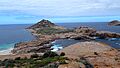
View of southern end of Pearson Island
-
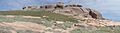
Rock formations and southern end of South Pearson Island
-
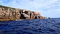
Northern anchorage of Pearson Island
-
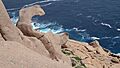
"The Craw" rock formation on the northern side of Pearson Island
-
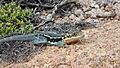
Peninsula Dragon on Pearson Island
-
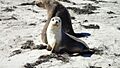
Sea Lion Mother and Cub on Pearson Island
-
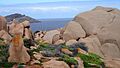
Top of Pearson Island and Pearson Island Rock Wallaby
See also
 In Spanish: Isla Pearson para niños
