Pelican Butte facts for kids
Quick facts for kids Pelican Butte |
|
|---|---|

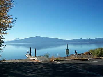
Pelican Butte from across Agency Lake
|
|
| Highest point | |
| Elevation | 8,037 ft (2,450 m) NAVD 88 |
| Geography | |
| Location | Klamath County, Oregon, U.S. |
| Parent range | Cascades |
| Topo map | USGS Pelican Butte |
| Geology | |
| Age of rock | Pleistocene |
| Mountain type | Shield volcano |
| Volcanic arc | Cascade Volcanic Arc |
| Last eruption | Pleistocene |
| Climbing | |
| Easiest route | Dirt road |
Pelican Butte is a large, steep-sided shield volcano in southern Oregon. It's part of the Cascade Range, a chain of mountains that stretches along the western United States.
This volcano is located about 28 miles (45 km) south of Crater Lake. It's also 12 miles (19 km) northeast of Mount McLoughlin. Pelican Butte is one of the biggest volcanoes in this area. It's so large that it's almost the size of some of the taller, cone-shaped volcanoes called stratovolcanoes.
Even though it's in the Cascades, Pelican Butte sits a bit apart from the main mountain line. It formed over cracks in the Earth's crust. Long ago, during the Ice Age, huge glaciers carved a bowl-shaped valley, called a cirque, into its northeast side. Despite this, the volcano still looks much like it did originally.
Scientists aren't exactly sure when Pelican Butte last erupted. They think it was between 200,000 and 700,000 years ago. The volcano first had some explosive eruptions. Later, it produced thinner flows of lava.
Today, Pelican Butte is part of the Fremont-Winema National Forest and the Sky Lakes Wilderness. Many different plants and animals call this area home. Native Americans, like the Klamath people, used to hunt and gather berries here thousands of years ago.
You can find a fire lookout tower at the very top of Pelican Butte. The United States Forest Service uses it to spot forest fires. A gravel road leads all the way to the summit, making it easier to visit.
Contents
Where is Pelican Butte?
Pelican Butte is in Klamath County, in the southeastern part of Oregon. It's close to Fish Lake. You can reach it from Oregon Highway 140.
The volcano is inside the Fremont–Winema National Forest. It's also part of the Sky Lakes Wilderness, a large protected area managed by the United States Forest Service. This wilderness covers about 113,849 acres (461 km2) of land. The land here ranges from 3,800 feet (1,158 m) to 9,495 feet (2,894 m) high.
How Tall is Pelican Butte?
Pelican Butte reaches a height of 8,037 feet (2,450 m). It has very steep sides. Even though glaciers carved into it long ago, its original shape is still mostly there.
During the Pleistocene epoch, which was from about 2.58 million to 11,700 years ago, glaciers were very active. They created a canyon and a cirque on the volcano's northeast side. These glaciers also made the summit a bit lower. Today, the volcano doesn't have large glaciers anymore.
Pelican Butte is a very large volcano, with a volume of about 20 cubic kilometers (4.8 cubic miles). This makes it one of the biggest shield volcanoes in the Cascades. It's even about 33 percent larger than nearby Mount McLoughlin.
Animals and Plants of Pelican Butte
Trees and Plants on the Volcano
At lower elevations on Pelican Butte, around 4,429 feet (1,350 m), you'll mostly see Douglas fir and Ponderosa pine trees. As you go higher, to about 5,413 feet (1,650 m), the Shasta red fir becomes more common. Even higher, around 5,741 feet (1,750 m), both red fir and white fir trees grow.
Near the very top, you can find endangered western white pine trees. These trees are important for birds like Clark's nutcrackers and gray jays. Mountain hemlock trees also grow at higher elevations. Around the lakes in the Sky Lakes Wilderness, lodgepole pines are more common. You might also spot Engelmann spruce trees.
The smaller plants growing under the trees include huckleberry, snowbrush, heather, and manzanita.
Wildlife in the Sky Lakes Wilderness
Many animals live in the Sky Lakes Wilderness area around Pelican Butte. In the summer and early fall, you might see elk. Other animals include American martens, American black bears, cougars, coyotes, and small creatures like pikas and golden-mantled ground squirrels. Birds like ospreys and American bald eagles also live here.
Scientists have studied the animals that northern spotted owls hunt. They found that northern flying squirrels, bushy-tailed woodrats, and voles live at Pelican Butte. Less common prey animals include deer mice and Townsend's chipmunk, as well as insects. Some of the lakes in the area are stocked with fish for fishing. Nearby Klamath Lake has several types of sucker fish, including the endangered Lost River sucker and shortnose sucker.
How Pelican Butte Formed
Pelican Butte is part of a volcanic area called the Quaternary Mount McLoughlin Reach. This area has 33 volcanic vents spread over 357 square miles (925 km2). It stretches from Pelican Butte to Aspen Lake.
Pelican Butte is a type of volcano called a shield volcano. These volcanoes have gentle slopes, like a warrior's shield lying on the ground. They are built up by many layers of fluid lava flows.
The volcano sits on older volcanic rock that erupted millions of years ago. The lava from Pelican Butte is mostly made of andesite and basaltic andesite. These lavas contain minerals like plagioclase, augite, hypersthene, and olivine.
Near the top of Pelican Butte, you can find tuff breccia and lapilli. These are pieces of rock and ash from explosive eruptions. Later, lava flows covered these materials. The summit of Pelican Butte also has a small cinder cone.
Nearby Volcanoes
Imagination Peak is a small cone with lava flows located northwest of Pelican Butte. Brown Mountain is another shield volcano nearby. It's much smaller than Pelican Butte. Brown Mountain erupted between 60,000 and 12,000 years ago. Glaciers also carved into Brown Mountain, creating a bowl-shaped cirque on its northeast side.
History of Pelican Butte
Name and Early People
Pelican Butte gets its name from nearby Pelican Bay, which is at the northern end of Upper Klamath Lake. Native Americans used to call the mountain Mongina. The United States Coast and Geodetic Survey once called it Lost Peak.
Ancestors of the Klamath and Takelma people lived in this area thousands of years ago. They hunted animals and gathered huckleberries. Mountains in the Cascades were sometimes used for special rite of passage ceremonies for young Klamath Native Americans.
When white settlers arrived, they also hunted, trapped animals like beaver and marten, and grazed their livestock in the Sky Lakes Wilderness. In the early 1900s, the United States Forest Service started building trails and fire lookouts.
The Fire Lookout Tower
Pelican Butte has a fire lookout tower on its summit. The first lookout was built in the early 1900s. It was replaced several times over the years. The current metal lookout tower was built in 1986. The United States Forest Service still maintains it today. It's located at an elevation of 7,994 feet (2,437 m).
In 1984, the United States Congress officially made the Sky Lakes Wilderness area, including Pelican Butte, a protected wilderness. This area also has historical spots like the Waldo Tree, which was marked by a politician named John B. Waldo in 1888. There's also the Twin Ponds Trail, which follows an old military wagon road from the 1860s.
Fun Things to Do at Pelican Butte
Visiting the Summit
A gravel road goes all the way to the top of Pelican Butte. It branches off Oregon Route 140. This road is only open during the summer months when there's no snow. The last few miles are steep and narrow, so it's best to use a vehicle with good ground clearance.
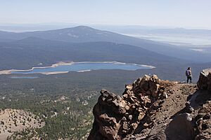
From the summit, you get an amazing 180-degree view of the Cascades. You can see mountains stretching from south of Crater Lake all the way to Mount McLoughlin. In winter, a special trail for snowmobiles is maintained by a local club. The Pacific Crest Trail, a famous long-distance hiking trail, also passes through the Sky Lakes Wilderness area for about 35 miles (56 km).
Ski Area Plans
For many years, people have tried to create a ski resort on Pelican Butte. These plans started in the 1960s. However, these ideas have always faced opposition from groups like the U.S. Fish and Wildlife Service and local residents.
In the 1990s and early 2000s, a company called Jeld-Wen spent a lot of money planning a ski area. However, as of 2025, there are no current plans to build a ski area on Pelican Butte.
 | May Edward Chinn |
 | Rebecca Cole |
 | Alexa Canady |
 | Dorothy Lavinia Brown |


