Powell, Ohio facts for kids
Quick facts for kids
Powell, Ohio
|
|||
|---|---|---|---|
|
|||

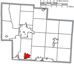
Location of Powell in Delaware County
|
|||
| Country | United States | ||
| State | Ohio | ||
| County | Delaware | ||
| Township | Liberty | ||
| Founded | 1801 | ||
| Incorporated | 1947 | ||
| Area | |||
| • Total | 5.82 sq mi (15.07 km2) | ||
| • Land | 5.82 sq mi (15.06 km2) | ||
| • Water | 0.00 sq mi (0.01 km2) | ||
| Elevation | 935 ft (285 m) | ||
| Population
(2020)
|
|||
| • Total | 14,163 | ||
| • Density | 2,435.60/sq mi (940.35/km2) | ||
| Time zone | UTC-5 (Eastern (EST)) | ||
| • Summer (DST) | UTC-4 (EDT) | ||
| ZIP code |
43065
|
||
| Area code(s) | 614, 740 | ||
| FIPS code | 39-64486 | ||
| GNIS feature ID | 2396264 | ||
| Website | www.cityofpowell.us | ||
Powell is a city in Delaware County, Ohio, United States. It is located about 14 miles (21.5 km) north of Columbus, the state capital. In 2020, about 14,163 people lived there. Powell was founded in the early 1800s and is now a suburb of Columbus. This means many people who live in Powell work in Columbus.
Contents
History of Powell, Ohio
Early Beginnings and Native American Lands
The area where Powell is today was once a large wilderness. Native American tribes lived here. These included the Huron, Wyandot, Miami, Delaware, Ottawa, Shawnee, Mingo, and Erie.
Explorers from France and Europe began surveying the region in the 1600s. Great Britain, France, and the Iroquois League all claimed this land at different times. By the 1700s, it became known as the Ohio Country.
During the American Revolution, several states claimed parts of this land. These states included Connecticut, New York, Pennsylvania, and Virginia. After the war, the Land Ordinance of 1785 opened the area for new settlers. Many of these settlers were veterans of the war. They received land as payment for their service. In 1787, this region became the Northwest Territory.
How Powell Grew: From Middlebury to a City
The first settlers arrived in what is now Powell on May 1, 1801. The land was owned by Thomas R. Hall. By 1813, the settlement was called "Middlebury." This name might have come from early settlers who were from Middlebury, Connecticut. Today, Powell still has streets and neighborhoods named Middlebury.
Middlebury was a small town. Its residents worked as farmers, hat makers, buggy makers, and blacksmiths. In 1839, Thomas R. Hall bought more land nearby. He then opened a general store. In 1850, Middlebury was renamed "Hall's Corner" after him. Sometimes it was called "Hall Corners."
In 1857, Hall's Corner wanted an official post office. A judge had to approve this request. The village was then renamed Powell to honor this judge.
The Columbus and Toledo Railroad (C&T) came to Powell in 1872. This brought new chances for the settlers. The railroad mainly carried coal from Appalachia to other areas. In 1899, C&T joined with two other railroads. It became part of the Hocking Valley Railway. Today, much of this line is still used for freight by CSX Transportation.
Powell became an official municipality in 1947. It was known as the Village of Powell. Its population stayed small until the late 1980s. Then, new homes were built as the Columbus area grew north. In 20 years, Powell's population grew from 378 to over 6,000 people. In 2000, Powell officially became a city.
Between 2000 and 2010, Powell's population almost doubled again. This was partly because about 1,000 acres of land were added in 2002. This land was used to build the Golf Village community.
Working Together: Powell and Liberty Township
In 1995, some leaders in Powell wanted the village to separate from Liberty Township. They voted for this idea without asking the community. This made residents upset. They started a petition to let the community vote on the issue.
If Powell separated, it would lose its fire department services. It would also affect future plans for the community. Those who wanted to separate felt that Liberty Township relied too much on local property taxes. Powell residents were paying about $95,000 a year to the township.
Residents needed 74 signatures for a vote. A group collected 179 signatures. But the Village Council refused the petition. They said there was a technical problem with the rules. However, the mayor decided that the petition was valid.
Because of the strong public interest, the Village Council agreed to let people vote. The vote happened on August 8. Out of 384 residents who voted, 98 (26%) wanted to separate. But 286 (74%) voted against it. So, Powell stayed part of Liberty Township. Since then, Powell and Liberty Township have had a good relationship.
Geography of Powell
The city of Powell is located between the Scioto and Olentangy Rivers. It is about 14 miles (21.5 km) north of Columbus. Powell is centered around the intersection of State Route 750 and C.R.9. This intersection is known as Liberty Street within Powell. Residents often call it the Four Corners.
Powell is part of Liberty Township. This township was the site of the first settlement in Delaware County, Ohio. According to the United States Census Bureau, Powell covers a total area of about 4.93 square miles (12.77 square kilometers). All of this area is land.
Population and People
| Historical population | |||
|---|---|---|---|
| Census | Pop. | %± | |
| 1880 | 131 | — | |
| 1950 | 384 | — | |
| 1960 | 390 | 1.6% | |
| 1970 | 374 | −4.1% | |
| 1980 | 387 | 3.5% | |
| 1990 | 2,154 | 456.6% | |
| 2000 | 6,247 | 190.0% | |
| 2010 | 11,500 | 84.1% | |
| 2020 | 14,163 | 23.2% | |
| Sources: | |||
Powell's Population in 2010
In 2010, the census showed that 11,500 people lived in Powell. There were 3,796 households and 3,227 families. The city had about 2,333 people per square mile (901 people per square kilometer). There were 3,975 housing units.
Most people in Powell were White (88.5%). There were also people who were African American (1.9%), Native American (0.1%), and Asian (7.5%). About 1.4% of the population was Hispanic or Latino.
About 53.5% of households had children under 18 living with them. Most households (77.8%) were married couples living together. The average household had 3.03 people. The average family had 3.33 people.
The average age in Powell was 37.4 years. About 34.7% of residents were under 18. About 7.7% were 65 or older. The population was almost evenly split between males (49.2%) and females (50.8%).
Economy
Powell is mainly a bedroom community north of Columbus. This means that most people who live in Powell travel to other towns for their jobs. More than 90% of working residents commute to other places for work.
Parks and Recreation
The City of Powell has nine public parks for everyone to enjoy. These include Village Green Park, which hosts the yearly Powell Festival. Other parks are Adventure Park, Arbor Ridge Park, Library Park, Oak Park, Beechwood Park, Meadowview Park, Murphy Park, and Seldom Seen Park.
These parks offer many sports facilities. You can find courts for basketball, volleyball, tennis, and pickleball. There are also areas for skating and soccer. Village Green Park has a splash pad, a place for concerts, a playground, and covered shelters. Bike paths and multi-use trails connect many parks to nearby neighborhoods.
Education
Powell is part of the Olentangy Local School District. The city is home to one of the district's high schools, Olentangy Liberty High School. It also has Tyler Run Elementary. The Olentangy Local School District received the highest rating from the Ohio Department of Education in 2020. This rating was "excellent with distinction."
Powell also used to have a private school called Village Academy. It taught students from kindergarten through 12th grade. This school closed in the summer of 2019. Powell has a branch of the Delaware County District Library.
Notable People from Powell
- A. J. Arcuri, NFL football player (Los Angeles Rams)
- Tala Ashe, Actress (Legends of Tomorrow)
- Jon Busch, MLS Soccer Player (Chicago Fire S.C.)
- D. Michael Crites, United States Attorney for the Southern District of Ohio
- Emily Douglas, founder of Grandma's Gifts
- Melina Kanakaredes, actress (CSI: NY)
- Gary Levox, Rascal Flatts singer
- Seth Lucas, racing driver
- Thad Matta, former OSU basketball coach
- Chinedum Ndukwe, former NFL football player (Cincinnati Bengals and Oakland Raiders)
- Greg Oden, former NBA basketball player (Portland Trail Blazers, Miami Heat)
- Chris Perry, Former PGA golfer
- Michael Redd, former NBA basketball player (Milwaukee Bucks and Phoenix Suns)
- Lou Rosselli, wrestling coach (University of Oklahoma)
- Robert Smith, former NFL football player (Minnesota Vikings)
- Valerie Still, former ABL and WNBA basketball player (Columbus Quest and Washington Mystics)
- R. J. Umberger, NHL hockey player (Philadelphia Flyers, Columbus Blue Jackets)
- Mike Vrabel, former NFL football player (Pittsburgh Steelers, New England Patriots, and Kansas City Chiefs)
- William White, former NFL football player (Detroit Lions, Kansas City Chiefs, and Atlanta Falcons)
See also
 In Spanish: Powell (Ohio) para niños
 | Anna J. Cooper |
 | Mary McLeod Bethune |
 | Lillie Mae Bradford |


