Purupuruni facts for kids
Quick facts for kids Purupuruni |
|
|---|---|
| Purupurini | |
| Highest point | |
| Elevation | 5,315 m (17,438 ft) |
| Geography | |
| Location | Peru, Tacna Region |
| Parent range | Andes |
| Geology | |
| Age of rock | Holocene |
Purupuruni is a group of lava domes in southern Peru. Lava domes are like piles of thick, sticky lava that have slowly oozed out of the ground. Purupuruni is one of many volcanoes in Peru. Its activity is linked to how the Earth's plates move. This happens when the Nazca Plate slides under the South America Plate.
Purupuruni is also connected to a geothermal field and a large bowl-shaped hole called a caldera. The volcano was active a long time ago, about 53,000 years ago. It was also active more recently, around 5,300 years ago. Today, Purupuruni is not considered very dangerous, but scientists are still watching it closely.
Contents
Where is Purupuruni?
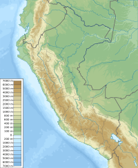
Purupuruni is located in the Cordillera Occidental mountain range. This is about 48 kilometers (30 miles) north of the border with Chile. It is also about 85 kilometers (53 miles) from the city of Tacna. The volcano is part of a special natural park called the Monumento Natural de Los Volcanes de Mauri. The name "Phuru" means "dung" in the Aymara language.
The Purupuruni volcano is also known as Purupurini. It is a group of four large lava domes. These domes are about 0.85 kilometers (0.5 miles) wide. They reach an elevation of about 5,315 meters (17,438 feet) above sea level. The domes cover an area of about 3.5 to 7 square kilometers (1.4 to 2.7 square miles). They can be up to 200 meters (656 feet) tall.
The lava came out of cracks in the ground called fissure vents. The volcanoes have also been affected by faults, which are cracks in the Earth's crust. Purupuruni sits on the edge of a large dip in the ground. This dip looks like a 13-kilometer (8-mile) wide caldera. The volcano is located southeast of the Yucamane volcano. It is also just south of the Mauri River, which flows into Lake Titicaca.
Hot Springs and Nature
The Borateras geothermal field is near Purupuruni. A geothermal field is an area where heat from inside the Earth comes to the surface. It has about 40 different hot spots. This field is also connected to nearby volcanoes like Coverane and Jaruma. The Borateras field is used as a spa at a place called Calachaca. The area around the volcano is quite dry and cold. Because of this, there are not many plants growing there.
What is Purupuruni Made Of?
The rocks that make up Purupuruni are mainly andesitic and dacitic. These are types of volcanic rock. They contain minerals like amphibole, biotite, olivine, plagioclase, and pyroxene. These rocks are part of a larger group called the "Purupurini Volcanics." This group also forms other volcanoes in the region.
Purupuruni and other volcanoes in the area formed on top of older rocks. These older rocks include sediments from the Cretaceous period.
Volcanoes in Peru
Volcanoes in Peru are mostly found in the southern part of the country. There are about 300 different volcanic systems there. Some famous ones include El Misti, Ubinas, and Sabancaya. In the Tacna Region of Peru alone, there are over 60 separate volcanoes. Two of these, Tutupaca and Yucamane, have been active in recent history.
There are also many geothermal systems in the region. These systems have very hot water, over 200 degrees Celsius (392 degrees Fahrenheit). This heat could be used to create geothermal energy. All this volcanic and geothermal activity happens because the Nazca Plate is sliding under the South America Plate. This movement happens at a speed of about 7 to 9 centimeters (2.8 to 3.5 inches) per year.
How Old is Purupuruni?
The volcanoes in this area, including Purupuruni, are from the Miocene to Pliocene ages. Purupuruni itself formed within the last 100,000 years. Scientists have used different methods to find its age. One method suggests it is about 53,000 years old. Another method shows that one of the southern domes is about 5,300 years old.
Even though it's not very active, the Peruvian Geological Institute started monitoring Purupuruni in 2018. They also watch nine other volcanoes. There were some small earthquakes in 2020 and 2021 near Purupuruni. However, these quakes were caused by local faults, not by the volcano itself.
During the Pleistocene Ice Age, glaciers moved across Purupuruni. They left behind piles of rock and dirt called moraines on the domes. However, more recent studies suggest that the domes themselves were not eroded by glaciers. The area around the volcano has deposits from rivers, glaciers, and wind. These include volcanic ash that covers the volcanic structures.
See also
 In Spanish: Purupuruni para niños


