
Tutupaca facts for kids
Quick facts for kids Tutupaca |
|
|---|---|

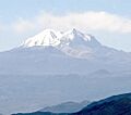
Tutupaca viewed from a southern direction.
|
|
| Highest point | |
| Geography | |

Tutupaca
Location in Peru
|
|
| Geology | |
| Mountain type | Stratovolcanoes |
| Volcanic arc | Andean Volcanic Belt |
| Last eruption | 1802 |
Tutupaca is a large volcano in the Tacna Region of Peru. It is part of a chain of volcanoes in the Andes mountains called the Central Volcanic Zone. Tutupaca is made up of three volcanoes that overlap each other. They were formed by lava flows and lava domes. These grew on top of older volcanic rocks. The highest part of Tutupaca is about 5,815 meters (19,078 feet) tall. In the past, this mountain was covered by glaciers.
Many volcanoes in Peru have been active recently, including Tutupaca. Their activity happens because the Nazca Plate is sliding under the South America Plate. This process is called subduction. One part of Tutupaca collapsed a long time ago, probably in 1802. This caused a huge landslide of rock and dirt, and a fast-moving cloud of hot gas and ash called a pyroclastic flow. This eruption was one of the biggest ever recorded in Peru. The volcano started forming about 700,000 years ago. It continued to be active into the Holocene period (our current geological age). The Peruvian government plans to watch Tutupaca for any future activity. Tutupaca also has geothermal features like fumaroles (steam vents) and hot springs.
Contents
Stories About Tutupaca
People in a town called Candarave used to think of Tutupaca as a "bad" mountain. They thought of another volcano, Yucamane, as the "good" one. This idea might have come from Tutupaca having eruptions more recently. A Peruvian writer named Mateo Paz Soldán even wrote a special poem about Tutupaca.
Where is Tutupaca?
Tutupaca is about 25 to 30 kilometers (15 to 19 miles) north of Candarave in the Tacna Region of Peru. Lake Suches is to the north of the volcano. Two rivers flow nearby: the Callazas River to the east and the Tacalaya River to the west. The weather here is cold, and the ground is rocky with not much plant life. When it rains, the mountain gets covered in snow. The melting snow from Tutupaca and other mountains helps fill the rivers in the area.
How Tutupaca Formed
Tutupaca is made of two main parts. There's an older part that has been worn down a lot. Then there are two newer peaks to the north. The eastern peak is about 5,790 meters (18,996 feet) high. It has seven lava domes that likely formed in the Holocene period. The western peak is the highest point of Tutupaca, reaching about 5,815 meters (19,078 feet). It has lava domes, lava flows, and ash deposits from the Pleistocene age (the Ice Age).
The base of Tutupaca is between 4,400 and 4,600 meters (14,400 and 15,100 feet) high. The volcano covers an area of about 150 to 170 square kilometers (58 to 66 square miles). The older part of the volcano is mostly made of lava flows. During the Ice Age, glaciers carved out U-shaped valleys and left behind piles of rock called moraines.
What Tutupaca is Made Of
The older parts of Tutupaca and its western peak have erupted rocks called andesite and dacite. The eastern peak has mostly produced dacite. These rocks also contain minerals like amphibole, biotite, plagioclase, and quartz. Sometimes, small pieces of darker rocks are found inside Tutupaca's rocks. The rocks at the bottom of the volcano have been changed by hot water, forming clays. There are also deposits of sulfur at Tutupaca. A map from 1996 even shows a sulfur mine on the side of the volcano.
When Part of Tutupaca Collapsed
A large, bowl-shaped area about 1 kilometer (0.6 miles) wide on the eastern side of Tutupaca was formed when a big part of the volcano collapsed. This collapse created a long trail of rock and debris, about 6 to 8 kilometers (3.7 to 5 miles) long. This debris trail is mostly found in old glacial valleys. A pyroclastic flow called Paipatja also happened during this collapse. It reached Lake Suches to the north and the Callazas River to the east.
The debris from the collapse looks different in different places. Some areas have hills about 100 to 200 meters (330 to 660 feet) long, which is common for volcanic landslides. Other areas have ridges that are 100 to 150 meters (330 to 490 feet) long and up to 30 meters (98 feet) high. These differences show that the collapse happened in stages.
The collapse likely started in the volcano's hot water system and then affected a growing lava dome. The total amount of material that collapsed was huge, probably more than 0.6 to 0.8 cubic kilometers (0.14 to 0.19 cubic miles). The collapse covered an area of about 12 to 13 square kilometers (4.6 to 5 square miles). This wasn't the first time Tutupaca collapsed. Other collapses happened 6,000 to 7,500 years ago and before 17,000 to 25,000 years ago. Big collapses like this have happened at other volcanoes, such as Mount St. Helens in 1980. They can cause massive landslides.
Why Volcanoes Form Here
Off the coast of Peru, the Nazca Plate is sliding under the South America Plate at a speed of about 5 to 6 centimeters (2 to 2.4 inches) per year. This movement causes volcanoes to form in the Andes mountains, including Tutupaca. Other Peruvian volcanoes include Sara Sara, Coropuna, El Misti, and Ubinas. In the past, major eruptions happened in Peru, like the one at Huaynaputina in 1600. That eruption killed 1,500 people and even changed the climate around the world.
The land around Tutupaca is made of old folded rocks and newer volcanic rocks. There are many cracks and breaks in the Earth's crust, called faults, which have been active for millions of years. One of these faults crosses Tutupaca from north to south.
Climate and Plants
Most volcanoes in the Central Volcanic Zone are higher than 4,000 meters (13,000 feet). Here, the weather is cold, and it often freezes. Most rain falls between January and March. At Tutupaca, about 200 to 560 millimeters (7.9 to 22 inches) of rain falls each year. In the Western Cordillera, between 3,500 and 3,900 meters (11,500 and 12,800 feet), you can find plants like cacti, herbs, and Peruvian feather grass. There are also lichens and mosses. Wet areas called bofedales have many different kinds of plants. Above 4,000 meters (13,000 feet), there are fewer plants. By 5,800 meters (19,000 feet), there was permanent snow between 2003 and 2012. Tutupaca is part of a protected area called the Vilacota Maure Regional Conservation Area.
Eruption History
The oldest rocks from Tutupaca are about 1,135,000 years old. The older part of the volcano was active first with lava flows, then with a big explosive eruption. A long quiet period followed before the western and eastern parts of Tutupaca became active. Some smaller lava domes on the older part are about 260,000 years old, while newer ones are 33,000 years old. Volcanic activity continued into the Holocene period, meaning the volcano could still erupt. Today, fumaroles (steam vents) are found on the top of Tutupaca, and small earthquakes have been recorded.
There are reports of eruptions in 1780, 1787, 1802, 1862, and 1902. Scientists have used radiocarbon dating to confirm that eruptions happened during this time. Some people used to think that the nearby Yucamane volcano was the source of these eruptions. However, studies have shown that Yucamane last erupted about 3,000 years ago. This means the eruptions reported in 1787 and 1802 most likely came from Tutupaca.
The collapse of eastern Tutupaca happened along with an eruption. This eruption was one of the biggest in Peru's history. Ash from it fell as far as 165 kilometers (103 miles) south in Arica. Scientists believe this collapse happened between 1731 and 1802, likely linked to the 1802 eruption. The eruption was probably caused by new, hot magma entering the volcano's magma chamber. Before the main collapse, a pyroclastic flow erupted, possibly because a lava dome collapsed. This flow left a deposit up to 6 meters (20 feet) thick on the east side of Tutupaca. The previous eruption might have made the volcano unstable, leading to the big collapse. At that time, not many people lived in the area, so the eruption didn't affect many lives.
Dangers from Tutupaca
Because of Tutupaca's past, scientists think it could erupt again and cause another collapse. If this happens, about 8,000 to 10,000 people could be in danger. Nearby geothermal power plants and mining areas would also be at risk. Several small towns, dams, irrigation canals, and two main roads would also be vulnerable. Other dangers from an eruption include falling rocks, pyroclastic flows (hot gas and ash clouds), ash and pumice rain, volcanic gases, and lahars (volcanic mudflows). Tutupaca, along with Ubinas and Huaynaputina, is one of three volcanoes in Peru that have had very large explosive eruptions.
The Peruvian geological institute, INGEMMET, has created a map showing the danger zones around Tutupaca. In 2017, Tutupaca was chosen as one of the volcanoes to be watched by a new observatory in southern Peru. This observatory will monitor earthquake activity, changes in the gases from fumaroles, and any changes in the volcano's shape. It will also use real-time video. This project started in 2019 and involves building 30 monitoring stations. Regular reports on the volcano's activity began in May 2019. Tutupaca is currently considered "moderately dangerous."
Hot Springs and Energy
Tutupaca is also the name of a geothermal area near the volcano. This area includes places like Azufre Chico and the Callazas River. They are all part of the same geothermal system, where temperatures deep underground are hotter than 200°C (392°F). These areas have fumaroles, geysers, mud pots, and deposits of sulfur. Hot springs at the base of Tutupaca release warm water into the rivers.
Tutupaca has been considered a possible place to build a geothermal power plant. In 2013, two energy companies planned to work together on a geothermal project at Tutupaca.
Images for kids
-
Tutupaca volcano

See also
 In Spanish: Tutupaca para niños
