Rushall, West Midlands facts for kids
Quick facts for kids Rushall |
|
|---|---|
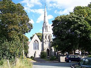 Rushall Parish Church, dedicated to St Michael the Archangel |
|
| Population | 11,871 (2011, Rushall-Shelfield Ward) |
| Metropolitan borough |
|
| Metropolitan county | |
| Region | |
| Country | England |
| Sovereign state | United Kingdom |
| Post town | WALSALL |
| Postcode district | WS4 |
| Police | West Midlands |
| Fire | West Midlands |
| Ambulance | West Midlands |
| EU Parliament | West Midlands |
Rushall is a suburb located in the Metropolitan Borough of Walsall. This area is part of the West Midlands in England. It sits along the main road that connects Walsall and Lichfield. Rushall was first mentioned in the famous Domesday Book in 1086. However, most of its growth has happened since the 1920s. Historically, Rushall was part of Staffordshire. Later, it became part of the Walsall district.
Contents
Rushall's Rich History
The first time Rushall was written about was in the Domesday Book in 1086. Back then, it was a small village with eight homes and a mill. Its yearly value was about 10 shillings. The name "Rushall" means "a place in marshy ground where rushes grow."
Early settlers, called Saxons, likely started living north of Rushall Hall. There are still remains of a moated site there. In the 1800s, people found Saxon coins during digs in this area.
The Old Church and Manor
Rushall did not have its own church at first. In 1220, a place of worship was called a chapel of Walsall. But the lords of Rushall worked to make it a proper parish church. In 1440, John Harpur rebuilt Rushall Church on the chapel's site. It was next to his manor house. This church survived the English Civil War. It was rebuilt again between 1854 and 1866. The old square tower of the manor house stayed until 1867. Today, the remains at Rushall Hall are a protected ancient monument.
Rushall Hall's Story
The ruins of the old manor house are in Rushall. During the Wars of the Roses and the English Civil War, this house was very strong. It had many soldiers defending it. In 1640, a man tried to bribe a captain to betray the soldiers at Rushall. But his plan was found out, and he was punished. A newer house, Rushall Hall, was built close to the ruins.
The manor used to belong to the Bowles family. Then it passed to the Harpurs. John Harpur helped fund the church and rebuilt it around 1444. In the 1600s, the manor went to the Leigh family. They were important in county politics.
At the start of the Civil War in 1642, Sir Edward Leigh was a Member of Parliament. He was against the King. He made Rushall Hall stronger and joined the Parliamentary Army. His wife was left in charge of the Hall. But she could not hold it against Prince Rupert's forces in 1643. The Royalists were then forced out after a short fight in 1644.
Limestone and Nature
Limestone is a high-quality rock found close to the surface in Rushall. Romans and people in the Middle Ages used it for building and farming. During the Industrial Revolution, limestone was used to help make iron. This caused a big increase in mining. New areas like Daw End grew. The Hay Head and Linley mines were very large.
The quarries in Rushall Hall's park later filled with water. They became the Park Lime Pits. Today, this area is a nature reserve. The Arboretum lakes, also once in Rushall, were formed in a similar way by quarrying.
Who Lives in Rushall?
In 2020, an estimate showed that Rushall and nearby Shelfield had about 12,182 people. About 48.8% were male and 51.2% were female. Most people were Christian (71%). About 22.8% said they had no religion. Other religions included Sikh (3%), Muslim (1.1%), Hindu (0.6%), and Buddhist (0.3%).
Most people in the area were White (90%). Other groups included Asian (5.4%), Black (1.8%), and Mixed Race (2.4%). There are several churches in Rushall and nearby. Mosques, Sikh, and Hindu Temples are found in nearby Walsall, Lichfield, and Birmingham.
Things to Do in Rushall
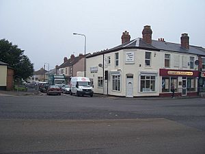
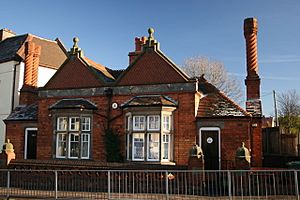
Rushall has a main shopping centre. It is split by a busy road junction. Here you can find basic shops and services. There is also a war memorial. A library used to be here but closed in 2017. You can find a McDonald's on Daw End Lane.
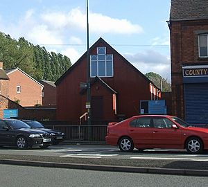
Other places include a small church called "Christ The King Church." There is also a Labour Club, a Travis Perkins factory, and a Community Centre. You can also find a methodist church on Daw End Lane. Rushall has two public houses (pubs) and a nature reserve called "Park Lime Pits Local Nature Reserve." There are also a few takeaways and small shops.
Learning in Rushall
Rushall used to have two secondary schools, Pelsall and Manor Farm. Both of these schools are now closed. However, there are still two primary schools. There is also a Key Stage 4 centre for older students. A pre-school called Piccolo Bambini is located at Manor Farm. Walsall College is also close to Rushall.
Rushall's Location
Rushall is located about 2.3 miles (3.7 km) north of Walsall. It is 3 miles (4.8 km) west of Aldridge and 8 miles (12.9 km) southwest of Lichfield. Birmingham is about 12 miles (19.3 km) to the north-northwest. Wolverhampton is 8 miles (12.9 km) to the east, and Bloxwich is 2 miles (3.2 km) to the southeast.
Rushall is part of a larger residential area. This includes nearby villages and areas like Shelfield, Pelsall, Ryecroft, Walsall Wood, Blakenall Heath, Pool Green, and Leamore. These areas act as suburbs for Walsall, Bloxwich, Aldridge, and Brownhills.
While Rushall is mostly urban, some parts are still rural. There is a small greenbelt area near Daw End Lane, Pool Green, Winterley Lane, and Walsall Arboretum. The village is situated between Walsall, Bloxwich, Aldridge, Brownhills, and Lichfield.
Getting Around Rushall
Bus Services
Rushall has bus services mainly from National Express West Midlands and Chaserider. Here are some of the main routes as of 2022:
- 8 (National Express West Midlands): Travels from Walsall to Lichfield. It goes through Rushall, Pelsall, Brownhills, and Burntwood.
- 9/9A (National Express West Midlands): Connects Walsall to Wolverhampton. It passes through Rushall, Pelsall, Bloxwich, Wednesfield, and Heath Town.
- 10 (National Express West Midlands): Goes from Walsall to Brownhills West. It travels via Rushall and Walsall Wood.
- 35 (National Express West Midlands): Runs from Walsall to Aldridge via Rushall (Sundays only).
- 35A (Chaserider): Connects Walsall to Leighswood. It goes through Rushall and Aldridge.
- 36 (Chaserider): Travels from Walsall to Lichfield. It passes through Rushall, Aldridge, Lazy Hill, and Shenstone.
- 997 (National Express West Midlands): Goes from Walsall to Birmingham. It travels via Rushall, Aldridge, Pheasey, Old Osscot, and Perry Barr.
There are also other bus services that serve different parts of Rushall and nearby areas.
Train Stations
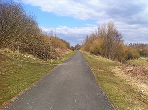
Rushall railway station was open from 1849 to 1909. It was on the old South Staffordshire Line between Walsall and Lichfield City. The station was located off Station Road. Today, the site is part of the McClean Way Greenway. However, it is kept safe for any possible future use for trains.
The village has also been served by other train stations nearby:
Past Stations
- Aldridge: This station was on the Sutton Park Line. This line is still used for freight trains. A new Aldridge station might be built in the future.
- Birchills Halt: This was on the Chase Line in nearby Leamore, about 2 miles away.
- North Walsall: This station was on the old Wolverhampton and Walsall Railway. It was in nearby Birchills and Leamore, about 2 miles away.
- Pelsall: This station was also on the old South Staffordshire Line. Its site is now part of the McClean Way Greenway. It is also protected for future rail use.
- Walsall Wood: This station was on the old Aldridge to Brownhills Branch. The site is now home to Oak Park Leisure Centre and a park.
Current Stations
- Blake Street: This station is on the Cross-City Line. It connects Lichfield Trent Valley and Birmingham New Street.
- Bloxwich: This station is on the Chase Line. It connects Birmingham, Walsall, Cannock, and Rugeley Trent Valley.
- Shenstone: This station is also on the Cross-City Line. It connects Lichfield and Birmingham.
- Walsall: This is a main junction. It connects the Chase Line, Walsall-Wolverhampton Line, and the old Grand Junction Railway.
Airports Near Rushall
The closest major airport is Birmingham Airport. Other airports nearby include Manchester Airport, John Lennon Airport, and East Midlands Airport. For private flights, there are Aldridge Airport and Wolverhampton Airport.
 | Selma Burke |
 | Pauline Powell Burns |
 | Frederick J. Brown |
 | Robert Blackburn |


