
Rye, New Hampshire facts for kids
Quick facts for kids
Rye, New Hampshire
|
||
|---|---|---|
|
Town
|
||

Jenness State Beach at sunset
|
||
|
||

Location in Rockingham County and the state of New Hampshire
|
||
| Country | United States | |
| State | New Hampshire | |
| County | Rockingham | |
| Founded | 1623 | |
| Incorporated | 1785 | |
| Villages |
List
|
|
| Area | ||
| • Total | 36.8 sq mi (95.2 km2) | |
| • Land | 12.6 sq mi (32.7 km2) | |
| • Water | 24.1 sq mi (62.5 km2) 65.63% | |
| Elevation | 75 ft (23 m) | |
| Population
(2020)
|
||
| • Total | 5,543 | |
| • Density | 438/sq mi (169.3/km2) | |
| Time zone | UTC−5 (Eastern) | |
| • Summer (DST) | UTC−4 (Eastern) | |
| ZIP Codes |
03870 (Rye)
03871 (Rye Beach) |
|
| Area code(s) | 603 | |
| FIPS code | 33-66180 | |
| GNIS feature ID | 0873712 | |

Rye is a town located in Rockingham County, New Hampshire, United States. In 2020, about 5,543 people lived here. Rye is famous for its beautiful state parks along the Atlantic Ocean.
Contents
History of Rye
The first settlement in New Hampshire began in 1623 at Odiorne's Point. It was called Pannaway Plantation and was started by fishermen led by David Thompson. This early settlement was later moved to what is now Portsmouth.
The first person to settle in the area that is now Rye was likely William Berry. Before it became its own town, Rye was known as "Sandy Beach." Its land was once part of other towns like New Castle, Portsmouth, Greenland, and Hampton.
In 1726, Sandy Beach became a separate parish (a church district) of New Castle and was named "Rye." This name came from Rye in England. The Jenness family, who still live in Rye today, came from that English town and even have a beach named after them. Rye officially became an incorporated town in 1785.
Geography of Rye
Rye is located right on the shore of the Atlantic Ocean. The town covers about 32.7 square kilometers (12.6 square miles) of land. A large part of Rye, about 62.5 square kilometers (24.1 square miles), is water. This means water makes up over 65% of the town's total area!
Rye also includes four of the nine Isles of Shoals, which are islands about 10 kilometers (6 miles) off the coast. The highest point in Rye is Breakfast Hill, which is 46 meters (151 feet) above sea level.
State Parks and Beaches
Rye has several state parks and beaches along its coastline, perfect for outdoor fun:
- Jenness State Beach
- Rye Harbor State Park
- Wallis Sands State Beach
- Odiorne Point State Park, which is 135 acres (55 hectares) and home to the Seacoast Science Center.
Getting Around Rye
Route 1A is a scenic road that runs along the coast through Rye. Other smaller roads like U.S. Route 1 and Route 1B also pass through the town. The closest major highway is I-95.
For air travel, the nearest airport is Portsmouth International Airport at Pease. Larger airports are Logan Airport in Boston, Massachusetts, and Portland International Jetport in Maine.
Rye Beach Village
In the southern part of Rye, there's a village called Rye Beach. This village has its own post office and even its own rules for building and planning.
Neighboring Towns
Rye shares its borders with these towns:
- Portsmouth (to the northwest)
- New Castle (to the northeast)
- Kittery, Maine (also to the northeast)
- North Hampton (to the southwest)
- Greenland (to the west)
Population of Rye
| Historical population | |||
|---|---|---|---|
| Census | Pop. | %± | |
| 1790 | 865 | — | |
| 1800 | 890 | 2.9% | |
| 1810 | 1,020 | 14.6% | |
| 1820 | 1,127 | 10.5% | |
| 1830 | 1,172 | 4.0% | |
| 1840 | 1,205 | 2.8% | |
| 1850 | 1,295 | 7.5% | |
| 1860 | 1,199 | −7.4% | |
| 1870 | 993 | −17.2% | |
| 1880 | 1,111 | 11.9% | |
| 1890 | 978 | −12.0% | |
| 1900 | 1,142 | 16.8% | |
| 1910 | 1,014 | −11.2% | |
| 1920 | 1,196 | 17.9% | |
| 1930 | 1,081 | −9.6% | |
| 1940 | 1,246 | 15.3% | |
| 1950 | 1,982 | 59.1% | |
| 1960 | 3,244 | 63.7% | |
| 1970 | 4,083 | 25.9% | |
| 1980 | 4,508 | 10.4% | |
| 1990 | 4,612 | 2.3% | |
| 2000 | 5,182 | 12.4% | |
| 2010 | 5,298 | 2.2% | |
| 2020 | 5,543 | 4.6% | |
| U.S. Decennial Census | |||
In 2010, there were 5,298 people living in Rye. Most residents (about 97.8%) were white. About 0.9% were Asian, and 0.8% were from two or more races. About 1.1% of the population identified as Hispanic or Latino.
Education in Rye
Kids in Rye can go to public schools in town from kindergarten through eighth grade. The school district for Rye is called School Administrative Unit 50 (SAU-50). It also serves students from Greenland, Newington, and New Castle. After eighth grade, high school students from Rye attend Portsmouth High School.
Elementary and Middle School
- Rye Elementary School is for students from kindergarten to fifth grade. It's the first and largest school for Rye students in SAU-50. In 2013, there were 330 students, with about 11 students for every teacher.
- Rye Junior High serves grades six, seven, and eight. Students from the nearby town of New Castle also join Rye Junior High after sixth grade. In 2013, there were 220 students, with about 9 students for every teacher.
Private Schools
Rye also has a few private schools:
- Rye Country Day is a private preschool.
- The Children's House Montessori School is another preschool located on Sagamore Road.
- Learning Skills Academy is a private non-profit school for students with learning differences. It helps students from third to eleventh grade.
Notable People from Rye
Many interesting people have lived in Rye:
- Craig Benson (born 1954): A former governor of New Hampshire.
- William Berry (1610–1654): Thought to be the first settler of Rye.
- Dan Brown (born 1964): A famous author, known for books like The Da Vinci Code.
- Scott Brown (born 1959): A former U.S. senator from Massachusetts.
- Judd Gregg (born 1947): Another former governor of New Hampshire and U.S. senator.
- Chip Kelly (born 1963): A well-known college football coach.
- Dave O'Brien (born 1963): A sportscaster for ESPN and the voice of the Boston Red Sox baseball team.
- Laurence Tosi (born 1968): A business leader who was the Chief Financial Officer of Airbnb.
Historic Places in Rye
Rye has several important buildings and places listed on the National Register of Historic Places. These places are recognized for their historical importance.
Here are some of them:
- The Beach Club
- Elijah Locke House
- Parsons Homestead
- Pulpit Rock Tower
- Rye Town Hall
- St. Andrew's-by-the-Sea
The Isles of Shoals are also recognized as a U.S. Historic District.
Images for kids
-
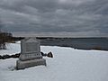
An 1899 monument marking where settlers likely landed in 1623.
-
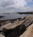
Interesting rock formations near Odiorne Point State Park.
-
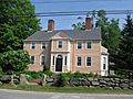
The historic Parsons Homestead in Rye.


See also
 In Spanish: Rye (Nuevo Hampshire) para niños
