
Safed facts for kids
Quick facts for kids
Safed (Tzfat)
|
||
|---|---|---|
| Tzfat | ||
| Hebrew transcription(s) | ||
| • ISO 259 | Çpat | |
| • Translit. | Tz'fat | |
| • Also spelled | Tsfat, Tzefat, Zfat, Sfat, Ẕefat (official) | |
   .jpg)  |
||
|
||

Safed (Tzfat)
Location in Northeast Israel

Safed (Tzfat)
Location in Israel
|
||
| Country | ||
| District | Northern | |
| Sub-district | Safed | |
| Founded | 1500 BCE | |
| Elevation | 850 m (2,790 ft) | |
| Population
(2024)
|
||
| • Total | 42,117 | |
| Website | http://www.zefat.muni.il | |

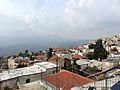
Safed (also called Tzfat) is a city in the Northern District of Israel. It is known for being the highest city in the Galilee region and in all of Israel. Safed sits high up, reaching elevations of about 937 meters (3,074 feet) above sea level.
This ancient city has a long and interesting past. It was mentioned by the Roman-Jewish historian Josephus and in the Jerusalem Talmud. Safed became important during the time of the Crusades and later under the Mamluk rulers. In the 1500s, it grew into a major center for Jewish learning and textile making. It is one of the Four Holy Cities of Judaism.
Today, Safed is a lively city with a large Haredi community. It is a hub for Jewish religious studies. The city also has a hospital, a college, and a famous Artists' Quarter. Its cool climate and beautiful views make it a popular place for visitors.
Contents
Exploring Safed's Past
Ancient Beginnings
Safed is a very old city. It was known as Sepph, a strong town in the Upper Galilee, mentioned by the Roman-Jewish historian Josephus. The Jerusalem Talmud also talks about Safed. It was one of five high places where fires were lit to announce the New Moon and festivals. This happened during the Second Temple period.
Crusaders and Castles
Before the Crusaders arrived, there was a village in Safed. A document from 1034 shows that Jewish people lived there alongside Muslims. In the early 1100s, there was a "flourishing village" with a tower called Burj Yatim.
Building the Crusader Fortress
The Crusaders took control of the area in 1101–1102. They built a large fortress in Safed in 1168. This castle was meant to stop attacks from the Turks. It was greatly expanded and became very strong.
Changes Under Ayyubid Rule
In 1188, the Ayyubid leader Saladin captured Safed after a long siege. He allowed the people to move to Tyre. Later, in 1219, the Safed castle was destroyed to prevent Crusaders from using it again.
The Second Crusader Fortress
In 1240, Safed returned to Crusader control through a treaty. The Knights Templar rebuilt the Citadel of Safed. This new fortress was even bigger. It could hold 2,200 soldiers during wartime. A town quickly grew around the fortress, with markets and many people.
The Mamluk Era

The Mamluks took over Egypt in 1250. In 1266, the Mamluk sultan Baybars captured Safed after a six-week siege. He kept the fortress because of its important location. In 1268, Baybars repaired and strengthened the fortress. He also built many things in the town, like markets and baths. He turned the town's church into a mosque, called Jami al-Ahmar (the Red Mosque), which was finished in 1275. Safed became a busy town and fortress under Baybars.
Safed became the main city of one of the Mamluk provinces, called Mamlakat Safad. This province covered the entire Galilee region.

A geographer named Abu'l Fida described Safed around 1300. He said it was a medium-sized town with a very strong castle. The castle had underground water systems. Its neighborhoods spread over three hills. Safed was an important base for troops guarding the coast.
The Black Death in 1348 caused the population of Safed to decline. The city also faced famines, plagues, and natural disasters.
Ottoman Times and Growth
A Time of Prosperity in the 1500s
The Ottomans took control of Syria in 1516. Safed's people gave the keys of their citadel to Sultan Selim I. In 1517, there were attacks in Safed, and many Jewish people were targeted. Safed became the capital of the Safed Sanjak, a larger province.
In the 1500s, Safed's population grew a lot. By 1567–1568, there were 1,931 households. The Jewish population especially increased, from 233 households in 1525 to 945 households. The city had different neighborhoods, some Muslim and some Jewish. The Jewish neighborhoods were named after the places their residents came from, like Portugal or Castile.

Safed became a major center for Kabbalah (Jewish mysticism) in the 1500s. Many important rabbis came to Safed after Jewish people were expelled from Spain in 1492. These included Isaac Luria and Joseph Caro.
Jewish immigrants, especially from Spain, helped Safed become a global center for Jewish learning. They also developed the textile industry. Safed became an important place for making wool and textiles. In 1577, the first Hebrew printing press in West Asia was set up in Safed.
Changes and Revival in the 1800s

Ottoman rule returned in 1840. Reforms helped Safed's population and economy grow. In 1849, Safed had about 5,000 people, including Muslims, Jews, and Christians. The Jewish population grew in the late 1800s with immigrants from Persia, Morocco, and Algeria. Moses Montefiore helped rebuild synagogues and Jewish homes in Safed.
Safed became an important economic center for the Upper Galilee. Its merchants helped trade grain between local farmers and traders in Acre. By the late 1800s, Muslim merchants became more involved in trade.

In 1878, Safed got a municipal council. The city's status in the Upper Galilee grew stronger. The Ottomans also made Safed a center for Sunni Islam. By 1879, Safed had over 15,000 people, with 8,000 Muslims and 7,000 Jews.
British Mandate Period

Safed was the center of the Safad Subdistrict during the British Mandate. In 1922, Safed had 8,761 people: 5,431 Muslims, 2,986 Jews, and 343 Christians. Safed remained a mixed city, but tensions between Jewish and Arab communities grew. In 1929, 20 Jewish residents were killed in a riot by local Arabs.
By 1948, the city had about 12,000 Arabs and 1,700 Jews. The United Nations Partition Plan for Palestine suggested Safed be part of a Jewish state. During the 1948 war, Arab groups attacked the Jewish Quarter. Jewish forces later captured the city. Most of the Arab population left or were forced to leave. Safed then became part of the new state of Israel.
Safed in Modern Israel
In 1974, 25 Israeli Jews, mostly schoolchildren, were killed in the Ma'alot massacre. In the 1990s and early 2000s, Safed welcomed thousands of Jewish immigrants from Russia and Ethiopia. In 2006, rockets fired from Southern Lebanon hit Safed, killing one person and injuring others. Many residents left the city during that conflict.
Safed continues to be a unique center for Jewish studies. In 2010, some rabbis urged residents not to rent or sell property to Arabs. This was seen as being aimed at the Arab students at Zefat Academic College.
City Life and People
Population and Communities
In 2008, Safed had a population of 32,000 people. Most of the city's residents are Jewish. Safed is home to a large community of Haredi Jews, who focus on religious studies. The village of Akbara, with about 500 Arab Muslims, is part of Safed's municipal area.
Earthquake Risk
Safed is located near the Dead Sea Transform, a major fault line. This means it is one of the cities in Israel most at risk of earthquakes. Other cities at risk include Tiberias and Eilat.
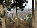
Safed's Location and Weather
Safed is about 40 kilometers (25 miles) east of Acre and 20 kilometers (12 miles) north of Tiberias.
Climate and Seasons
Safed has a Mediterranean climate. This means it has hot, dry summers and cool, wet winters. Sometimes it even snows in winter. The city gets about 682 millimeters (27 inches) of rain each year. Summers are warm, with average high temperatures around 31°C (88°F). Winters are cool, with average high temperatures around 10°C (50°F).
Learning and Culture
Education in Safed
Safed has 25 schools and 6,292 students. There are 18 elementary schools and 11 high schools. The Zefat Academic College became an independent college in 2007. In 2011, it started a program for Haredi women. This program allows them to get higher education while keeping their religious practices.
In October 2011, Israel's fifth medical school opened in Safed. It trains doctors in the Upper Galilee region. In 2021, the Prime Minister announced plans to establish Israel's 10th university in Safed.
Safed is one of Judaism's Holy Cities. It has several Yeshivas, which are schools for Jewish religious studies. These include Yeshivat Tzfat and the Hesder Yeshiva of Tzfat. For women, Sharei Bina is a seminary that teaches Jewish spirituality and Kabbalistic topics. Chabad also has several institutions in the city.
Art and Music Scene

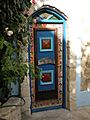
Artists' Colony
In the 1950s and 1960s, Safed was known as Israel's art capital. An artists' colony was set up in the old Arab quarter. Many famous Israeli artists came to work there. Today, this area has many galleries and workshops. You can find museums and galleries in the historic homes of artists like Moshe Castel.
Music and Festivals
Safed was once famous for its nightclubs in the 1960s. Today, Safed is known as the world's klezmer capital. It hosts an annual Klezmer Festival that brings musicians from all over the world. There is also a school for world music, especially Eastern music, called Maqamat.
Museums to Visit
- The Beit Hameiri museum shows the history of Safed's Jewish community over the last 200 years.
- The Museum of the Art of Printing displays the first Hebrew printing press.
Historic Places to See

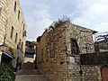
- Citadel Hill: This hill rises east of the Old City. It is named after the huge Crusader and Mamluk castle that once stood there. The castle was destroyed by an earthquake in 1837, but its ruins are still visible.
- Old Jewish Quarter: Before 1948, most of Safed's Jewish people lived here. It is also called the synagogue quarter. It has 32 synagogues, including those named after famous rabbis like Joseph Caro and Isaac Luria.
- Mamluk-period buildings: South of the Old Jewish Quarter, you can find two important Mamluk buildings. These include the Red Mosque (built in 1276) and a Mamluk mausoleum.
- Saraya: Southeast of the Artists' Quarter is the Saraya. This was a fortified home for the governor, built by Zahir al-Umar.
Notable People from Safed
Sister Cities
Safed is connected with these cities around the world:
 Erzsébetváros, Budapest, Hungary
 Guarda, Portugal
 Lille, France
 Nikopol, Bulgaria
 Palm Beach County, Florida, United States
 Toledo, Castile–La Mancha, Spain
Images for kids
-
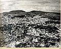
Safad in 1937
-
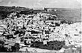
Mandate Police station at Mount Canaan, above Safed (1948)
-
Safed (1948)
-
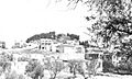
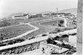
Safed Citadel (1948)
-
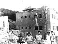
Safad Municipal Police Station after the battle (1948)
-
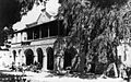
Bussel House, Safad, 11 April 1948: Yiftach Brigade headquarters
-
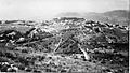
View of Safed from Mount Canaan (1948)
-
Mandate administration building on the eastern outskirts of Safed (1948)
-
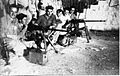
Yiftach Brigade, with their Hotchkiss machine guns, based at Bussel House, 1948
-
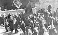
Druze parading in Safed after the Palmach victory in 1948
-
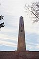
Monument to the Israeli soldiers who fought in the 1948 Arab–Israeli War
-
Safed in 2009
-
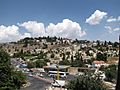
View of Safed
-
View of Safed
-
Houses in Safed
-
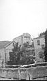
Doorway in Beit Castel gallery, Safed


.jpg)
See also
 In Spanish: Safed para niños
