Saguache County, Colorado facts for kids
Quick facts for kids
Saguache County
|
||
|---|---|---|

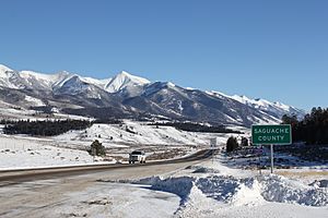
Entering Saguache County from the north on U.S. 285
|
||
|
||

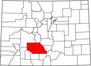
Location within the U.S. state of Colorado
|
||
 Colorado's location within the U.S. |
||
| Country | ||
| State | ||
| Founded | December 29, 1866 | |
| Seat | Saguache | |
| Largest town | Center | |
| Area | ||
| • Total | 3,170 sq mi (8,200 km2) | |
| • Land | 3,169 sq mi (8,210 km2) | |
| • Water | 1.7 sq mi (4 km2) 0.05%% | |
| Population
(2020)
|
||
| • Total | 6,368 | |
| • Estimate
(2023)
|
6,688 | |
| • Density | 2.0/sq mi (0.8/km2) | |
| Time zone | UTC−7 (Mountain) | |
| • Summer (DST) | UTC−6 (MDT) | |
| Congressional district | 3rd | |
Saguache County (say "suh-WATCH") is a county located in the state of Colorado. Its name comes from a Ute language word meaning "sand dunes." In 2020, about 6,368 people lived there. The main town and county seat is Saguache.
Contents
History of Saguache County
Saguache County was created on December 29, 1866. It was formed from the northern part of Costilla County in what was then the Territory of Colorado. Later, in 1872, a piece of Lake County was added to the northwest part of Saguache County, making it the size it is today.
Geography of Saguache County
Saguache County covers a large area of about 3,170 square miles. Most of this area is land, with only a very small part (about 1.7 square miles) being water. It is the seventh largest county in Colorado.
Neighboring Counties
Saguache County shares its borders with several other counties:
- Chaffee County - to the north
- Fremont County - to the northeast
- Custer County - to the east
- Huerfano County - to the southeast
- Rio Grande County - to the south
- Alamosa County - to the south
- Mineral County - to the southwest
- Hinsdale County - to the southwest
- Gunnison County - to the northwest
Main Roads in Saguache County
Protected Natural Areas
Saguache County is home to several important natural areas, including:
- Great Sand Dunes National Park and Preserve
- Great Sand Dunes Wilderness
- Gunnison National Forest
- La Garita Wilderness
- Rio Grande National Forest
- Sangre de Cristo Wilderness
Trails and Scenic Routes
You can find many trails and scenic routes in Saguache County, perfect for exploring nature:
- Colorado Trail
- Continental Divide National Scenic Trail
- Great Parks Bicycle Route
- Liberty Road (a historic mail route for walking, horses, and bikes)
- Medano Pass Primitive Road
- Montville Nature Trail
- Mosca Pass Trail
- Old Spanish National Historic Trail
- Sand Ramp Trail (a hiking trail near the sand dunes)
- Western Express Bicycle Route
Population and People
| Historical population | |||
|---|---|---|---|
| Census | Pop. | %± | |
| 1870 | 304 | — | |
| 1880 | 1,973 | 549.0% | |
| 1890 | 3,313 | 67.9% | |
| 1900 | 3,853 | 16.3% | |
| 1910 | 4,160 | 8.0% | |
| 1920 | 4,638 | 11.5% | |
| 1930 | 6,250 | 34.8% | |
| 1940 | 6,173 | −1.2% | |
| 1950 | 5,664 | −8.2% | |
| 1960 | 4,473 | −21.0% | |
| 1970 | 3,827 | −14.4% | |
| 1980 | 3,935 | 2.8% | |
| 1990 | 4,619 | 17.4% | |
| 2000 | 5,917 | 28.1% | |
| 2010 | 6,108 | 3.2% | |
| 2020 | 6,368 | 4.3% | |
| 2023 (est.) | 6,688 | 9.5% | |
| U.S. Decennial Census 1790-1960 1900-1990 1990-2000 2010-2020 |
|||
In 2000, there were about 5,917 people living in Saguache County. The population density was about 2 people per square mile. Many different groups of people live here. About 45% of the population identified as Hispanic or Latino.
The population included many young people, with about 28% being under 18 years old. The average age was 37 years. For every 100 females, there were about 101 males.
Towns and Communities
Towns in Saguache County
Smaller Communities
These are other communities in the county that are not officially towns:
Historic Places
Saguache County has nine places that are listed on the National Register of Historic Places. These are important sites that help tell the story of the county's past.
See also
 In Spanish: Condado de Saguache para niños
 | James Van Der Zee |
 | Alma Thomas |
 | Ellis Wilson |
 | Margaret Taylor-Burroughs |


