Scottsbluff, Nebraska facts for kids
Quick facts for kids
Scottsbluff, Nebraska
|
|
|---|---|

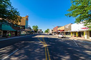
Looking South on Broadway in Downtown Scottsbluff, July 2017
|
|

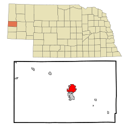
Location of Scottsbluff, Nebraska
|
|
| Country | United States |
| State | Nebraska |
| County | Scotts Bluff |
| Founded | 1900 |
| Area | |
| • Total | 6.68 sq mi (17.30 km2) |
| • Land | 6.63 sq mi (17.18 km2) |
| • Water | 0.04 sq mi (0.12 km2) |
| Elevation | 3,888 ft (1,185 m) |
| Population
(2020)
|
|
| • Total | 14,436 |
| • Density | 2,176.06/sq mi (840.19/km2) |
| Time zone | UTC−7 (Mountain (MST)) |
| • Summer (DST) | UTC−6 (MDT) |
| ZIP codes |
69361, 69363
|
| Area code(s) | 308 |
| FIPS code | 31-44245 |
| GNIS feature ID | 2396559 |
| Website | www.scottsbluff.org |
Scottsbluff is a city located in Scotts Bluff County, Nebraska, in the Great Plains area of the United States. In 2020, about 14,436 people lived there. Scottsbluff is the biggest city in the Nebraska Panhandle, which is the western part of Nebraska. It is also the 13th largest city in the whole state.
The city of Scottsbluff was started in 1899. It is named after a large hill, or bluff, located across the North Platte River. This bluff is now a protected area called Scotts Bluff National Monument. The monument was named after Hiram Scott, a fur trader who passed away near there in 1828.
A smaller town called Gering was founded nearby in 1887. Over time, Scottsbluff and Gering grew closer and now form the 7th largest urban area in Nebraska. This area is known as the Scottsbluff Micropolitan Statistical Area.
Contents
History of Scottsbluff
Scottsbluff was founded in 1899 by the Lincoln Land Company. This company was part of the Burlington Railroad. By 1900, the Burlington Railroad built tracks into the new town. They even used an old boxcar as a temporary train station.
Because Scottsbluff was the first town in the area with a railroad, some older businesses moved there from Gering. This helped Scottsbluff grow quickly.
Other Names for the City
In the Lakota language, Scottsbluff has a special name. It is called pȟaŋkéska wakpá otȟúŋwahe. This means "Platte River City," or literally "abalone river city."
Geography and Climate of Scottsbluff
Scottsbluff covers about 6.27 square miles (16.24 square kilometers). Most of this area is land, with a small part being water.
Understanding the Climate
Scottsbluff has a cold semi-arid climate. This means it's usually dry, but not a desert. It's also close to a humid continental climate with hot summers. The temperatures can change a lot between seasons and even within a single day. Summers are hot, and winters are dry and cold. Sometimes, warm chinook winds can blow through, making winter temperatures rise above 50°F (10°C).
The average temperature changes from about 28.3°F (–2.1°C) in December to 75.3°F (24.1°C) in July. Each year, Scottsbluff typically has:
- About 6 days where the temperature reaches 100°F (38°C) or higher.
- About 49 days where it reaches at least 90°F (32°C).
- About 27 days where the temperature stays at or below freezing (32°F or 0°C).
- About 12 days where the temperature drops to 0°F (–18°C) or lower.
Temperature Records
The hottest temperature ever recorded in Scottsbluff was 110°F (43°C) on July 11, 1939. The coldest was a very chilly −46°F (–43°C) on February 6, 1899. This was the record low for Nebraska for a short time.
Rain and Snow
Most of the rain in Scottsbluff falls in the spring and summer. May and June usually get the most rain. The most rain in one day was 3.18 inches (81 mm) on June 7, 1953. Some months have had almost no rain at all.
Snow usually falls in light amounts. On average, Scottsbluff gets about 42.5 inches (108 cm) of snow each winter. The most snow in one month was 31.3 inches (79 cm) in October 2009.
| Climate data for Scottsbluff, Nebraska (1991–2020 normals, extremes 1893–present) | |||||||||||||
|---|---|---|---|---|---|---|---|---|---|---|---|---|---|
| Month | Jan | Feb | Mar | Apr | May | Jun | Jul | Aug | Sep | Oct | Nov | Dec | Year |
| Record high °F (°C) | 74 (23) |
77 (25) |
87 (31) |
93 (34) |
103 (39) |
106 (41) |
110 (43) |
106 (41) |
105 (41) |
93 (34) |
81 (27) |
77 (25) |
110 (43) |
| Mean maximum °F (°C) | 61.2 (16.2) |
66.0 (18.9) |
75.9 (24.4) |
83.4 (28.6) |
91.9 (33.3) |
98.6 (37.0) |
102.1 (38.9) |
99.6 (37.6) |
95.8 (35.4) |
85.7 (29.8) |
72.8 (22.7) |
62.1 (16.7) |
102.8 (39.3) |
| Mean daily maximum °F (°C) | 41.7 (5.4) |
44.6 (7.0) |
54.9 (12.7) |
62.3 (16.8) |
71.9 (22.2) |
83.9 (28.8) |
90.7 (32.6) |
88.8 (31.6) |
79.9 (26.6) |
64.9 (18.3) |
51.7 (10.9) |
41.6 (5.3) |
64.7 (18.2) |
| Daily mean °F (°C) | 28.3 (−2.1) |
30.8 (−0.7) |
39.9 (4.4) |
47.5 (8.6) |
57.7 (14.3) |
68.7 (20.4) |
75.3 (24.1) |
73.0 (22.8) |
63.5 (17.5) |
49.3 (9.6) |
37.2 (2.9) |
28.0 (−2.2) |
49.9 (9.9) |
| Mean daily minimum °F (°C) | 14.9 (−9.5) |
17.0 (−8.3) |
25.0 (−3.9) |
32.6 (0.3) |
43.5 (6.4) |
53.6 (12.0) |
59.8 (15.4) |
57.3 (14.1) |
47.1 (8.4) |
33.6 (0.9) |
22.7 (−5.2) |
14.4 (−9.8) |
35.1 (1.7) |
| Mean minimum °F (°C) | −9.2 (−22.9) |
−4.1 (−20.1) |
6.9 (−13.9) |
16.9 (−8.4) |
28.3 (−2.1) |
40.7 (4.8) |
49.8 (9.9) |
46.4 (8.0) |
32.3 (0.2) |
15.6 (−9.1) |
2.3 (−16.5) |
−8.4 (−22.4) |
−16.1 (−26.7) |
| Record low °F (°C) | −33 (−36) |
−46 (−43) |
−27 (−33) |
−8 (−22) |
12 (−11) |
30 (−1) |
35 (2) |
30 (−1) |
14 (−10) |
−10 (−23) |
−21 (−29) |
−42 (−41) |
−46 (−43) |
| Average precipitation inches (mm) | 0.39 (9.9) |
0.56 (14) |
1.00 (25) |
1.92 (49) |
2.78 (71) |
2.54 (65) |
1.66 (42) |
1.24 (31) |
1.22 (31) |
1.23 (31) |
0.59 (15) |
0.52 (13) |
15.65 (398) |
| Average snowfall inches (cm) | 5.3 (13) |
7.5 (19) |
6.8 (17) |
5.2 (13) |
0.9 (2.3) |
0.0 (0.0) |
0.0 (0.0) |
0.0 (0.0) |
0.3 (0.76) |
3.5 (8.9) |
5.2 (13) |
7.8 (20) |
42.5 (108) |
| Average precipitation days (≥ 0.01 in) | 4.7 | 6.3 | 6.9 | 9.4 | 12.1 | 10.7 | 7.7 | 6.7 | 6.7 | 7.0 | 5.3 | 5.2 | 88.7 |
| Average snowy days (≥ 0.1 in) | 4.1 | 5.1 | 3.9 | 2.8 | 0.3 | 0.0 | 0.0 | 0.0 | 0.2 | 1.6 | 3.5 | 4.8 | 26.3 |
| Average relative humidity (%) | 64.4 | 62.6 | 60.2 | 56.2 | 58.0 | 56.7 | 56.0 | 57.5 | 56.9 | 55.9 | 62.1 | 65.2 | 59.3 |
| Source: NOAA (relative humidity 1961–1990) | |||||||||||||
People of Scottsbluff
| Historical population | |||
|---|---|---|---|
| Census | Pop. | %± | |
| 1910 | 1,746 | — | |
| 1920 | 6,912 | 295.9% | |
| 1930 | 8,465 | 22.5% | |
| 1940 | 12,057 | 42.4% | |
| 1950 | 12,858 | 6.6% | |
| 1960 | 13,377 | 4.0% | |
| 1970 | 14,507 | 8.4% | |
| 1980 | 14,156 | −2.4% | |
| 1990 | 13,711 | −3.1% | |
| 2000 | 14,732 | 7.4% | |
| 2010 | 15,039 | 2.1% | |
| 2020 | 14,436 | −4.0% | |
| U.S. Decennial Census | |||
Population in 2020
The 2020 census counted 14,436 people living in Scottsbluff. There were 6,011 households, which are groups of people living together. About 3,450 of these were families.
Most of the people in Scottsbluff were white (71.54%). Other groups included Black or African-American (1.18%), Native American (3.18%), and Asian (1.11%). About 29.0% of the population identified as Hispanic or Latino.
In terms of age, about 27.0% of the people were under 18 years old. About 19.5% were 65 years or older. The average age in the city was 35.2 years.
Population in 2010
In the census of 2010, Scottsbluff had 15,039 people. There were 6,168 households. The city's population density was about 2,418 people per square mile.
The racial makeup was mostly White (83.0%). About 29.1% of the population was Hispanic or Latino.
The average age in 2010 was 36 years. About 24.9% of residents were under 18 years old.
Education in Scottsbluff
Scottsbluff is an important center for learning in western Nebraska. It is home to the main campus of Western Nebraska Community College. This college offers many different programs and courses.
Other colleges and universities also have a presence in Scottsbluff. These include:
- The University of Nebraska Medical Center College of Nursing, where students can study to become nurses.
- Chadron State College, which offers various courses.
- The University of Nebraska (Panhandle Research and Extension Center), which focuses on research and helping the community.
There was once a college called Hiram Scott College a few miles north of the city, but it is no longer open.
Fun Places to Visit
Scottsbluff and the surrounding area have many interesting places to explore:
- Grave of Rebecca Winters (Mormon Pioneer): A historical site marking the burial place of a pioneer woman.
- Lake Minatare State Recreation Area: A great spot for outdoor activities like fishing and boating.
- Riverside Discovery Center: A zoo and nature center where you can see animals and learn about wildlife.
- Western Nebraska Community College: The local college campus.
- Fort Mitchell: A historic fort site.
- Cedar Canyon and Carter Canyon: Natural areas for hiking and enjoying nature.
- Robidoux Pass: A historic pass used by pioneers.
- Uptown Scottsbluff (formerly the Monument Mall): A place for shopping and entertainment.
Important Buildings in Scottsbluff
Scottsbluff has several landmark buildings that are important to its history and community:
- Old Post Office
- Midwest Theater: A historic theater listed on the National Register of Historic Places.
- Lincoln Hotel
- Great Western Sugar Factory
- Lake Minatare Lighthouse: A unique lighthouse located by the lake.
- Bluffs Middle School
- Scottsbluff High School
- Scottsbluff County Courthouse
- Scottsbluff Carnegie Library
Transportation in Scottsbluff
Getting Around Town: Tri-City Roadrunner
| Headquarters | 1825 10th St, Gering, NE |
|---|---|
| Locale | Scottsbluff, NE |
| Service area | Scottsbluff, Gering, and Terrytown |
| Service type | bus service, paratransit |
| Routes | 2 |
| Web site | [1] |
The Tri-City Roadrunner is the public bus system in Scottsbluff. It also serves the nearby towns of Gering and Terrytown. The buses run on weekdays from 6:30 AM to 6:30 PM. There is no service on weekends.
The system has two main bus routes: the Blue Route and the Orange Route. These routes travel north and south between Scottsbluff and Gering, covering different parts of the cities. The buses can also go a little off their usual path if needed, to pick up or drop off passengers closer to their homes.
Major Roads
Several important highways pass through Scottsbluff, making it easy to travel to and from the city:
 US 26: This is a U.S. Route that runs east and west through Scottsbluff.
 N-71: This is a Nebraska Route that runs north and south through Scottsbluff.
 N-92: This Nebraska Route goes west from Scottsbluff towards the Wyoming border.
Airport Travel
The Scottsbluff area is served by the Western Nebraska Regional Airport. From this airport, you can take flights on United Express to Denver International Airport twice a day.
Famous People from Scottsbluff
Many notable people have connections to Scottsbluff:
- Hank Bauer: A former American football player and later a sports broadcaster.
- Brook Berringer: A former University of Nebraska quarterback.
- Terry Carpenter: An American politician.
- Walt Conley: A folk singer, musician, and actor.
- Kip Gross: A retired Major League Baseball pitcher.
- Nik Ingersöll: An American entrepreneur and designer.
- Galen B. Jackman: A retired U.S. Army major general.
- Nate Lashley: A professional golfer on the PGA tour.
- Jacqueline Logan: A silent film actress who spent her childhood here.
- Vic Marker: A three-time Midwest Golden Glove boxer.
- Randy Meisner: A former bassist for the famous rock band the Eagles.
- Adrian Smith: A U.S. Representative (a type of politician in the US government).
- Jack Todd: An editor and sports columnist.
Sister City
Scottsbluff has a special connection with another city far away. It is a sister city with Bamiyan, Afghanistan.
See also
 In Spanish: Scottsbluff (Nebraska) para niños


