
Seligman, Missouri facts for kids
Quick facts for kids
Seligman, Missouri
|
|
|---|---|

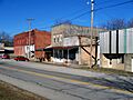
Downtown Seligman, Missouri. Drew Wilkerson's original general store, also known as "The Brick" sits on the corner on the left.
|
|

Location of Seligman, Missouri
|
|
| Country | United States |
| State | Missouri |
| County | Barry |
| Township | Sugar Creek |
| Settled | 1830s |
| Incorporated | March 8, 1881 |
| Named for | Joseph Seligman |
| Area | |
| • Total | 1.25 sq mi (3.23 km2) |
| • Land | 1.25 sq mi (3.23 km2) |
| • Water | 0.00 sq mi (0.01 km2) |
| Elevation | 1,522 ft (464 m) |
| Population
(2020)
|
|
| • Total | 813 |
| • Density | 651.96/sq mi (251.81/km2) |
| Time zone | UTC-6 (Central (CST)) |
| • Summer (DST) | UTC-5 (CDT) |
| ZIP code |
65745
|
| Area code(s) | 417 |
| FIPS code | 29-66530 |
| GNIS feature ID | 2396572 |
| Website | www.thecityofseligman.com |
Seligman is a city located in Barry County, Missouri, United States. It is part of Sugar Creek Township. In 2020, about 813 people lived there. The city is named after Joseph Seligman, a well-known businessman from the 1800s. The name "Seligman" comes from a Yiddish word meaning "a happy, cheerful person."
Contents
Geography of Seligman
Seligman is in the Ozarks region. The Mark Twain National Forest is to its east. The city sits on a ridge along Missouri Route 37. Rainwater west of the railroad flows into the Grand Lake o' the Cherokees. Water east of Seligman flows into Table Rock Lake. The area also has Karst topography, which means it has lots of limestone, sinkholes, and caves.
The United States Census Bureau says the city covers about 1.25 square miles (3.23 square kilometers). All of this area is land.
History of Seligman
Early Beginnings

Long ago, the area that is now Seligman was part of the Osage Nation lands. The French claimed this land as part of the Illinois Country. Later, they sold it to the United States in the Louisiana Purchase. The Osage people gave up their claims to the land in 1810.
First Settlers and Trails
Seligman started as a small trading post in the 1830s. The Roller family were some of the first European settlers. The area was a wild forest back then.
In 1841, the first road was built through the area. It is now called Old Wire Road. This road followed a path made by hundreds of Cherokee people in 1838. They were forced to move from their homes in what is known as the "Trail of Tears". A telegraph line was later built along this path.
By 1848, the Butterfield Stage Coach used a route through the area. This brought more settlers. By the 1860s, the trading post was called Roller's Ridge. Another early name for the community might have been Herdsville.
Early settlers cared a lot about education and religion. Two schools were built for children. They were "subscription schools," meaning parents paid the teacher a small fee each month. A Baptist church was also built nearby.
During the Civil War
During the Civil War, the town stopped growing. The area became very unsafe. Bushwhackers (groups of fighters) attacked people and stole their belongings. Local government stopped working for a few years. Before the Battle of Pea Ridge, important generals met in Roller's Ridge to plan their battle.
After the War
After the war, Roller's Ridge began to grow again. More settlers arrived. In 1866, Christian E. Fawver reopened Victory Mills, a gristmill (a mill for grinding grain). This mill was very important for local people. Before it opened, they had to travel far to grind their grain.
In 1872, a post office was set up, and the community was named Herdsville. A new school was built in 1876. A deep well was dug in the town center for water. Businesses grew, and a dray service (hauling goods by wagon) started in 1880.
The Railroad Arrives


In 1880, the Atlantic and Pacific Railroad built a train line to Herdsville. The railroad company gave 80 acres of land to build a town. They also designed the streets. The town was renamed Seligman on September 27, 1880. This was to honor Joseph Seligman, a rich railroad investor who had recently passed away.
On March 8, 1881, Seligman officially became a city. Joseph Seligman's widow, Babet Seligman, gave $500 and one acre of land to help build a church. This church, called the Union Church, was built in 1884. It is still standing today.
More trains brought many visitors, traders, and salespeople. Hotels like the Inmon House opened in 1881. The town grew to have many stores, hotels, a meat market, a stable, a lumber yard, and more. A local newspaper, the Seligman Sunbeam, also started in 1881.
In 1882, work began on another railroad line. This line, later called the Missouri and North Arkansas Railroad, went south and east from Seligman. It helped Seligman grow even more. Many passenger trains passed through Seligman daily. Salespeople often stayed in town and rented buggies to visit nearby towns.
Local businesses included poultry farming and timber. Farmers grew wheat, oats, corn, and raised cattle and hogs. They also grew fruits like peaches and strawberries. A large vineyard also grew grapes for juice and wine.
Challenges and Fires
Seligman faced many challenges, especially fires. On January 22, 1883, a big fire destroyed a large part of the town, including hotels, saloons, and stores. Two months later, the stagecoach company's stables burned down. Another fire in January 1884 destroyed more buildings.
Despite the fires, residents quickly rebuilt. Around 1892, Seligman built its first public school, a two-story building.
The 20th Century
In the early 1900s, Seligman continued to rebuild and modernize. The Southwestern Bell Telephone Company opened an office in 1904. Rural mail routes were set up. Banks like the Bank of Seligman opened in 1905. The North Arkansas train line was extended in 1910. Two doctors opened practices, and one even had a small hospital.
In 1914, a tomato cannery and a vinegar factory opened. There was also a short attempt to mine silver. Seligman was known for its many saloons before Prohibition. However, the town was still smaller than it had been before the fires.
Another major fire, the Christmas Fire, happened on December 25, 1922. It destroyed the center of downtown, including markets, restaurants, and hotels.
After this fire, Seligman struggled through much of the 20th century. The Great Depression and the decline of train travel after World War II caused the town's population to shrink. The Missouri and Northern Arkansas Railroad stopped running in 1958. The Frisco Station, an important train station, was torn down in 1966.
Seligman High School enrollment also dropped. In 1954, the high school moved to Washburn, Missouri. In 1964, the Seligman Elementary School gym roof collapsed, and all students moved to a new building in Washburn. The remaining Seligman school building later burned down.
In the 1990s, Seligman started projects to improve the town. These included a new city water tower and two city parks.
The 21st Century
More recently, Seligman has continued to improve. It now has a community center, a playground, a public library, and the James L. Bottorff Memorial Museum. A new fiber optic cable provides faster internet. In 2014, Wal-Mart opened a neighborhood store, which later became a Harp's grocery store in 2016.
Famous Visitors
It is said that William Jennings Bryan, a famous politician, once visited a Seligman saloon while waiting for a train.
Around 1904, Carrie Nation, a well-known activist against alcohol, visited Seligman. She stayed at the Linden Hotel. Even though Seligman had many saloons, she did not cause any damage. She simply gave a supporter a special bottle with a message about voting for prohibition.
In 1921, a famous outlaw named Henry Starr came to Seligman. He stayed at the Gladden Hotel. He tried to trick the bank into cashing a check. The next day, Starr and his group robbed the bank of $1,200. He was later shot and killed while robbing another bank in Harrison, Arkansas.
Climate
Seligman has a humid subtropical climate. This means it has four seasons. Summers are usually hot and humid, and winters are cold. Sometimes, cold air from the north moves into the area. Seligman is just east of "Tornado Alley," an area where tornadoes are common.
| Climate data for Seligman, Missouri | |||||||||||||
|---|---|---|---|---|---|---|---|---|---|---|---|---|---|
| Month | Jan | Feb | Mar | Apr | May | Jun | Jul | Aug | Sep | Oct | Nov | Dec | Year |
| Mean daily maximum °C (°F) | 7.4 (45.3) |
9.7 (49.5) |
14.3 (57.8) |
20.3 (68.5) |
24.1 (75.3) |
28.2 (82.8) |
31 (88) |
31 (88) |
27.1 (80.8) |
21.6 (70.8) |
14.3 (57.8) |
9 (48) |
19.8 (67.7) |
| Mean daily minimum °C (°F) | −4.6 (23.8) |
−2.7 (27.2) |
1.3 (34.4) |
7 (45) |
12.0 (53.6) |
16.6 (61.9) |
19.1 (66.3) |
18 (65) |
14.2 (57.5) |
8.4 (47.1) |
2.2 (35.9) |
−3 (27) |
7.4 (45.4) |
| Average precipitation mm (inches) | 58 (2.3) |
64 (2.5) |
89 (3.5) |
110 (4.4) |
130 (5.3) |
130 (5.2) |
89 (3.5) |
86 (3.4) |
110 (4.4) |
97 (3.8) |
89 (3.5) |
66 (2.6) |
1,130 (44.4) |
| Average precipitation days | 5 | 6 | 7 | 9 | 10 | 9 | 6 | 6 | 7 | 7 | 6 | 6 | 84 |
| Source: Weatherbase | |||||||||||||
Education
Seligman is part of the Southwest R-5 School District. Students from Seligman go to school in nearby Washburn. The school team is called The Trojans.
Population Data
| Historical population | |||
|---|---|---|---|
| Census | Pop. | %± | |
| 1960 | 387 | — | |
| 1970 | 424 | 9.6% | |
| 1980 | 508 | 19.8% | |
| 1990 | 593 | 16.7% | |
| 2000 | 877 | 47.9% | |
| 2010 | 851 | −3.0% | |
| 2020 | 813 | −4.5% | |
| U.S. Decennial Census | |||
2010 Census Information
In 2010, there were 851 people living in Seligman. There were 320 households and 233 families. The city had about 680 people per square mile. Most people (94.8%) were White. About 1.9% were Native American, and 0.5% were African American. About 2.7% of the population were Hispanic or Latino.
In the households, 37.2% had children under 18. About 50.6% were married couples. The average household had 2.66 people. The average family had 3.11 people.
The average age in the city was 37.3 years. About 27.7% of residents were under 18. About 10.6% were 65 or older. The population was almost evenly split between males (48.8%) and females (51.2%).
Images for kids
-
Downtown Seligman, Missouri. Drew Wilkerson's original general store, also known as "The Brick" sits on the corner on the left.
-

Location of Seligman, Missouri
See also
 In Spanish: Seligman (Misuri) para niños
