Sierra de Hoyo de Manzanares facts for kids
Quick facts for kids Sierra de Hoyo de Manzanares |
|
|---|---|
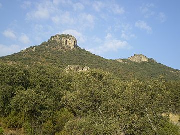
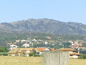
Southern slope of El Picazo composed by the summit of El Picazo 1268 m (left) and Peña Alonso 1295 m (right in the background), one of the main altitudes of the mountain chain.
|
|
| Highest point | |
| Peak | El Estepar (1402,840 meters above sea level) |
| Dimensions | |
| Length | 9 km (5.6 mi) |
| Width | 4 km (2.5 mi) |
| Area | 14 km2 (5.4 sq mi) |
| Geography | |
| Location | Community of Madrid |
| Country | |
| Parent range | Sierra de Guadarrama, (Sistema Central) |
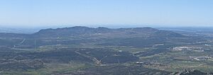
The Sierra de Hoyo, also known as the Sierra de Hoyo de Manzanares, is a mountain range in the northwest of Community of Madrid, Spain. It's close to the Sierra de Guadarrama, and even though it's part of the same geological family, there's about 10 kilometers of flat land separating them. The town of Hoyo de Manzanares is on its southern side and gives the mountain range its name.
This entire mountain area is inside the Cuenca Alta del Manzanares Regional Park. This park is a special protected area that also includes places like La Pedriza and the Santillana reservoir. It stretches south to Las Rozas de Madrid and includes the Soto de Viñuelas area near Tres Cantos. The park has different levels of protection. A large part of its southern and eastern slopes are protected as an Educational Natural Reserve, which is a very high level of protection. Also, since February 15, 1993, the area has been recognized as a Biosphere Reserve. The highest point in the Sierra de Hoyo is El Estepar, standing tall at 1402.840 meters.
You can reach this mountain range easily by road. One of the best ways is to take the Northwest highway from Madrid. You'll take exit 27 towards Torrelodones and then the M-618 road to Hoyo de Manzanares. This M-618 road starts in Colmenar Viejo. The Sierra de Hoyo can be seen from far away, especially its southern side when looking from Madrid.
Contents
Exploring the Sierra de Hoyo
Weather and Climate
The Sierra de Hoyo has a Mediterranean climate that's a bit more extreme due to its height and how it faces the sun. This means cool winters (and cold on the peaks) and warm summers. However, the summers here are much nicer than in the flat areas to the south. For example, the average yearly temperature is 14°C-15°C in Las Rozas (at 718 m), but it drops to 12°C-13°C in Hoyo de Manzanares (at 1002 m). Above 1200 m, temperatures are around 10°C. This is why you find oak trees and even some rare common juniper, which usually grow in colder mountain climates. The north side of the Sierra de Hoyo is much cooler than the south side.
Rainfall increases as you go higher up the mountain. The lowest rainfall is in Monte de El Pardo (700 m), with about 400-500 liters per square meter. In Hoyo de Manzanares, rainfall increases to about 600 liters per square meter each year. This is because the mountains trap clouds coming from the southwest, making the town quite rainy. This abundance of rain helps create green meadows for cattle and supports cork oaks and ash trees. Higher up in the sierra, rainfall reaches about 800 liters per square meter, which is why you can find eagle ferns and more oak trees.
Snow is not very common in the Monte de El Pardo area. It usually snows only a few times a year and doesn't stay long. Between 900 and 1000 meters high, snow becomes more common. It snows several times a year and often stays on the ground. It's easy for the snow to be more than 5 cm deep almost every winter, and sometimes it can reach 15 cm. In the highest parts of the sierra, snowfalls aren't much heavier than at 1000 m. However, because it's colder, the snow can last for more than a week above 1200 m. It's rare for snow to stay for more than two weeks.
Rocks and Landforms
The Sierra de Hoyo acts like a natural wall between the Manzanares River and the Guadarrama River. The Manzanares River valley is also to its southeast, through Monte de El Pardo. To the north, you'll find the Hoya de Villalba plain.
This mountain range is one of the main "monadnocks" in the Madrid area of the Sierra de Guadarrama. A monadnock is an isolated hill or mountain that stands out from a flat area. Other examples include the Sierra de La Cabrera (1564 m) and Las Machotas (1466 m). These mountains are separate from the main Guadarrama range because of cracks and faults in the earth that run parallel to the main mountains.
The Sierra de Hoyo forms a shape like an upside-down arch. Its ends are marked by the peaks of Navalospinos (1171 m) to the northeast, El Picazo (1268 m) to the south, and Peña Cardín (1130 m) to the northwest. In its southeastern lower areas, there are smaller mountains that connect to Monte de El Pardo, like La Solana (1002 m) in Hoyo de Manzanares. To the south, you might see isolated formations like Canto del Pico (1005.887 m) in Torrelodones. This is a very important granite rock formation. It's topped by a modernist palace, which was once owned by Francisco Franco, and gives the palace its name.
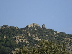
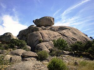
This mountain range is mostly made of granite and gneiss rocks. It also has some sections of microdiorites. In terms of its shape, it's similar to La Pedriza. You'll find lots of large boulders, rock piles (called canchales), and rocky outcrops (called berrocales) on its peaks, slopes, and lower areas. Some of these rocks have very unique shapes. For example, La Tortuga (1368 m) is named because it looks like a turtle. Canto del Pico (1011 m) looks like a bird's beak.
The highest point in the Sierra de Hoyo is the Estepar peak, located at 1402.840 meters. Other important peaks are around 1300 meters high. These include La Tortuga (1368 m), Canto Hastial (1374 m), Peñacovacha (1352 m), Silla del Diablo (1366 m), and the Campanarios (1342 and 1345 m). Slightly lower peaks include Cerro del Molinillo (1338 m), Peña Alonso (1295 m), and El Picazo (1268 m). The area with Peña Alonso and El Picazo is known as El Picazo. Other peaks are Solana in the Cerro de las Minas (1293 m) and Navalospinos (1171 m).
Rivers and Streams
This mountain range is part of two river systems: the Guadarrama River and the Manzanares River. The Manzanares River eventually flows into the Jarama River, which then flows into the Tagus River. Many streams start here, but because of the dry Mediterranean climate, most of them dry up in the summer. However, some streams like Peregrinos (flowing into the Guadarrama) and Trofas and Navahuerta (flowing into the Manzanares) have water all year round. These are considered the main rivers of the area.
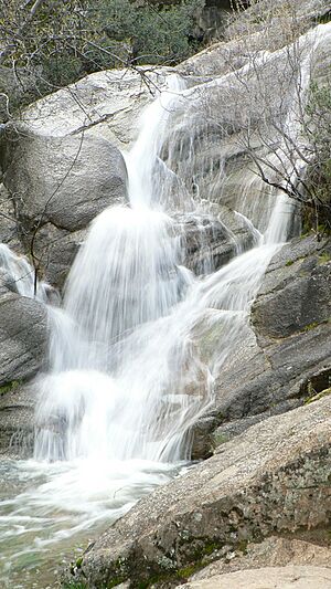
One notable stream is the Peña Herrera stream, located in Moralzarzal. It forms the Cascada del Covacho, a small but attractive waterfall when there's enough water.
The Peregrinos stream flows from the northern side of the mountain. After passing near the Parquelagos residential area in Galapagar, it joins the Guadarrama River. This happens just before the Guadarrama River goes under the Herrera bridge on the M-519 road from Torrelodones to Galapagar. The La Nava and La Torre streams, which flow through Torrelodones, also join the Guadarrama River.
The Manina and Trofas streams start on the southern slopes and flow into the Manzanares River after crossing Monte de El Pardo.
The Trofas stream creates the Gabriel Enríquez de la Orden reservoir. This reservoir is located at the foot of the sierra in the Los Peñascales residential area of Torrelodones. It's the main wetland in the mountain range area. Another small reservoir is Los Rosales (near the Parquelagos residential area in Galapagar), which gets its water from the La Pradera stream.
The Navahuerta stream is on the northern slope and flows into the Manzanares River, west of Colmenar Viejo.
Plants and Animals
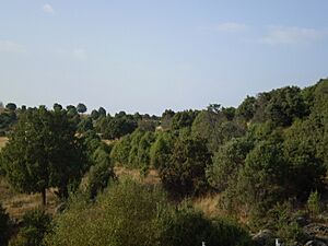
The Sierra de Hoyo is mostly covered by forests, but it also has many thick bushes and grasslands. These plants are typical of the Mediterranean region. The slopes are covered with holm oaks and junipers, as well as various shrubs. It's special because it has cork oak forests, which are not common at this height in the Iberian Peninsula.
On the southern slope, in the town of Hoyo de Manzanares, you'll find one of the best-preserved juniper forests in the Community of Madrid. This is a type of juniper called juniperus oxycedrus, also known as miera juniper or Spanish cedar. It's common in the Mediterranean area.
Further south, the juniper forests change into holm oak forests. These cover important natural areas like the El Pendolero and Cantos Negros estates. The Cantos Negros estate is even protected as a Natural Reserve by the Cuenca Alta del Manzanares Regional Park. These forests then spread towards Monte de El Pardo.
You can also find ash trees along the streams and brooks that flow through the sierra. In areas where the forest has been damaged, shrubs like rockrose and retama have replaced the trees. You'll also find aromatic plants such as lavender, thyme, and rosemary.
When it comes to animals, birds are very important here. You'll see corvids like the iberian magpie, and birds of prey such as booted eagles, buzzards, kites, and griffon vultures. Other birds include hoopoes and bee-eaters.
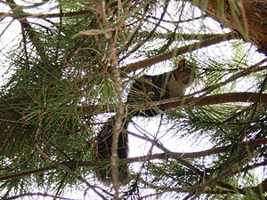
The main mammals living here are the squirrel, the wild boar, and the rabbit. Less common are the fox, the genet, and the dormouse. At the bottom of the mountains, temporary ponds form. These ponds are home to interesting amphibians like the common frog, the true toad, the natterjack toad, the spadefoot toad, the midwife toad, the pygmy newt, and the ribbed newt.
Towns and Roads Around the Sierra
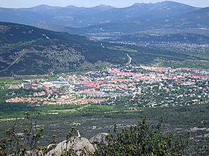
The Sierra de Hoyo is surrounded by many towns, residential areas, and roads. This means there's a lot of building and people living nearby, with some neighborhoods even built on the mountain slopes.
It's one of the busiest residential areas in the Community of Madrid. It's also very well connected by the A-6 highway (Northwest Highway), which runs along the western side of the mountains. Other important roads include the regional M-608 (Venturada-Collado Villalba), which passes along its northern side, and the local M-618 in the south.
To the south of the mountain range is Hoyo de Manzanares. To its west are the residential areas of Parquelagos (Galapagar) and La Berzosa (Hoyo de Manzanares), as well as the town of Collado Villalba. Collado Villalba has two main urban areas (La Estación and El Pueblo) with almost 60,000 permanent residents, plus many visitors.
Further north, you'll find Moralzarzal and Cerceda, which is one of the three parts of the municipality of El Boalo.
Historical Buildings and Art
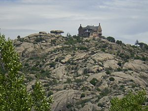
During the Andalusian period (when Muslims ruled parts of Spain), the Sierra de Hoyo was part of a defense system. This system was built by the Muslim people to stop Christian kingdoms from advancing. Two watchtowers from that time, built between the 9th and 11th centuries, are still standing. They were used to watch for enemies. La Torrecilla is mostly in ruins and is located on the training field of the Academy of the Corps of Engineers in Hoyo de Manzanares. It gives its name to the Collado de la Torrecilla, a mountain pass at 1185 m. The Torrelodones watchtower, in the town of the same name, is better preserved, though it has been changed over time.
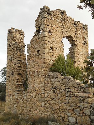
Another tower, on the mountain ridge between Estepar and La Tortuga, is also in ruins.
At the beginning of the 20th century, many mansions and small palaces were built around the Sierra de Hoyo for people to live in. Some impressive buildings still exist today. For example, the old Hostal de La Berzosa (now the main building of the Antonio de Nebrija University) is in the residential area of La Berzosa, which belongs to Hoyo de Manzanares. In Hoyo de Manzanares itself, near Torrelodones, you'll find the El Pendolero estate. This was the home of Antonio Maura, a famous politician. In Torrelodones, there's the former INI residence of Los Peñascales and the Palace of Canto del Pico. This palace was declared a historic and artistic monument in 1930.
Fun Facts
In the town of Hoyo de Manzanares, you can still see parts of old movie sets. Many films were shot here in the 1960s and 1970s, especially spaghetti westerns (like A Fistful of Dollars).
There are also some remains on the ground nearby of what used to be a street from the movie/musical Chicago.
The film director Carlos Saura used the El Pendolero estate as the setting for two of his well-known films: Ana and the Wolves (1972) and its sequel Mama Turns 100 (1979).
See also
 In Spanish: Sierra de Hoyo de Manzanares para niños
- Sierra de Guadarrama
- Cuenca Alta del Manzanares Regional Park
Main Peaks of the Sierra de Hoyo
- Estepar (Hoyo de Manzanares) 1402.840 meters above sea level (highest point)
- Solana (Moralzarzal) 1292.623 meters above sea level
- Canto Hastial 1374 m
- Peña Covacha 1352 m
- Silla del Diablo 1366 m
- Cerro del Molinillo 1338 m
- Peña Herrera 1289 m
- El Cuchillar 1204 m
- Peña de El Búho 1264 m
- Peña Alonso 1295 m
- El Picazo 1268 m
- Cancho de la Parra or La Tortuga 1368 m
- Campanario Pequeño 1343 m
- Campanario Grande 1345 m
- Riscos de Matalasgrajas 1323 m
- Pico de Matalasgrajas 1205 m
- Cerro Saluda 1199 m
- Cerro de Navalospinos 1171 m
- Calvache 1106.962 meters above sea level
Streams in the Sierra
- Navahuerta stream
- Manina stream
- Trofas stream
- Peregrinos stream
Important Monuments
Other Mountains Near Guadarrama
- Cabeza Mediana
- Cerro de San Pedro
- Las Machotas
- Sierra de La Cabrera
- Sierra de Ojos Albos
 | Bessie Coleman |
 | Spann Watson |
 | Jill E. Brown |
 | Sherman W. White |


