
Sint-Oedenrode facts for kids
Quick facts for kids
Sint-Oedenrode
|
|||
|---|---|---|---|
|
Town
|
|||
.jpg)  .JPG)    .JPG) .JPG) From top down, left to right: St. Martin Church square,
Henkenshage Castle, Dommelrode Castle and town hall, Knop Tower, former town hall, Monument to the Dutch, St. Paulus Hospice AD 1434, St. Damien Seminary |
|||
|
|||

Sint-Oedenrode
Location in North Brabant

Sint-Oedenrode
Location in Netherlands
|
|||
| Country | Netherlands | ||
| Province | North Brabant | ||
| Municipality | Meierijstad | ||
| Merged | 2017 | ||
| Area | |||
| • Municipality | 64.94 km2 (25.07 sq mi) | ||
| Elevation | 11 m (36 ft) | ||
| Population
(2021)
|
|||
| • Municipality | 18,360 | ||
| • Density | 282.72/km2 (732.25/sq mi) | ||
| Time zone | UTC+1 (CET) | ||
| • Summer (DST) | UTC+2 (CEST) | ||
| Postcode |
5490–5492
|
||
| Area code | 0413 | ||
| Market rights | AD 1232 | ||


Sint-Oedenrode (Dutch pronunciation: [sɪnt ˈudə(n)roːdə]) is a town in the Dutch province of North Brabant.
It is a town with a good number of buildings and people, located in the Meierij area near 's-Hertogenbosch. In 2021, Sint-Oedenrode had about 18,360 people living there. Its total area is about 64.94 square kilometers.
On January 1, 2017, Sint-Oedenrode joined with two other towns, Schijndel and Veghel. They formed a new, larger municipality called Meierijstad. This new municipality became the biggest in the North-Brabant province by land area.
Sint-Oedenrode used to have special "vrijheidsrechten" (freedom rights) since 1232. These were like early city rights. This lasted until 1851, when new laws changed how towns were governed. In the old days, Sint-Oedenrode was known as a "Vlek," which means a market town. Today, it is still a large town. The Dommel river flows through the town from southeast to northwest, dividing it.
Contents
- Town Areas and Hamlets
- How Sint-Oedenrode Got Its Name
- A Look at Sint-Oedenrode's Past
- How Sint-Oedenrode Developed
- Landscape and Nature
- Nature and Parks to Explore
- Local Government
- Important Buildings to See
- Museums to Visit
- Fun Facts About Sint-Oedenrode
- Awards and Recognition
- Famous People From Sint-Oedenrode
- Images for kids
- See also
Town Areas and Hamlets
The municipality of Sint-Oedenrode includes several areas and small villages called hamlets:
- There are 11 areas within Sint-Oedenrode itself. It also has 3 hamlets: "Everse," "Koevering," and "Kremselen."
- Boskant has 1 area and 3 hamlets: "De Bus," "Scheeken Vernhout," and "De Bunders."
- Olland has 1 area and 1 hamlet: "Houthem."
- Nijnsel has 1 area and 2 hamlets: "Vressel" and "Zwijnsbergen."
The town of Sint-Oedenrode has two old main parts: "Sint-Oedenrode" and "Eerschot." The Dommel river separates these two historical centers.
How Sint-Oedenrode Got Its Name
The name Sint-Oedenrode comes from a legend about Saint Oda. The story says that Oda was a blind girl from Scotland, or maybe Ireland, around the year 700. She was the daughter of King Eugenius VII. Her father sent her on a journey with a servant.
Oda's eyesight was amazingly healed after she visited the tomb of Saint Lambert of Maastricht in Liège. After this, she decided to dedicate her life to God as a nun. When she returned home, her father wanted her to marry. Oda did not want to marry, so she ran away back to the mainland. She traveled from place to place, looking for a quiet spot to worship. But magpies kept bothering her, so she kept moving to escape them.
Finally, she arrived in Toxandria (part of Austrasia) at a small settlement called Rode. "Rode" is an old Dutch word for a clearing in the woods made by people. The villagers built her a small hut on the heath, and she lived there as a hermit (someone who lives alone for religious reasons). She died in 726 A.D. After she passed away, people from all over the region came to visit the village. They started calling the place Sint-Oda's-Rode, which eventually became Sint-Oedenrode.
A Look at Sint-Oedenrode's Past
Sint-Oedenrode During World War II
During World War II, Sint-Oedenrode faced many challenges. In May 1940, the German Army invaded the Low Countries and France. There were small fights in Sint-Oedenrode as Dutch forces tried to slow down the enemy. After the Netherlands surrendered on May 15, 1940, Sint-Oedenrode was under German control. A small group of about 15 German air force (Luftwaffe) members were stationed there. They acted as lookouts for Allied planes flying missions against air bases in Volkel Air Base and Eindhoven.
In the last months of the occupation, the town's mayor was removed. A new mayor, who supported the Germans, was put in charge. The original mayor had been trying to help people hide from the "Arbeitseinsatz." This was a program where people were forced to work in German war factories. The mayor had helped by taking blank distribution cards, which were needed for food coupons, to give to men who were hiding. He also tried to stop the forced labor program.

In September 1944, Operation Market Garden began. Sint-Oedenrode became a very important place. It was located on a key route between the Allied landing zones in Son and Veghel. General Dwight D. Eisenhower and Field Marshal Bernard Montgomery needed to keep this route, called the "Corridor," open. This was so the British XXX Corps could move through to capture Nijmegen.
The US 101st Airborne Division liberated Sint-Oedenrode. They parachuted into nearby fields. Then, the British XXX Army Corps followed. For a short time, the 18th-century Henkenshage castle was used as the Allied headquarters.
The British lost 150 soldiers, and the Americans lost 125 soldiers in the area. Twenty-two British soldiers are buried in the General Cemetery in Sint-Oedenrode. Most British soldiers were later reburied at the Uden War Cemetery. Some were moved to Mierlo. American soldiers first buried in Wolfswinkel (Son en Breugel) were later reburied in Margraten or in the US.
On September 16, 1994, veterans from the 101st Airborne Division unveiled a war monument. This monument, called 'Monument for the Dutch,' was a gift from the veterans to the local people. It thanked the civilians who fought alongside the US troops. The monument's message is in English and says: "Dedicated to the people of the Corridor by the veterans of the 101st Airborne Division, in grateful appreciation of their courage, compassion and friendship." You can find this monument along the road called 'Corridor.' This road was built after the war to connect key points of the actual Allied supply route from Eindhoven to Nijmegen.
Sint-Oedenrode After the War
In the 20th century, two main companies helped Sint-Oedenrode grow. These were N.V. ODA Steel Works and Ovenbouw v/h H.J. van de Kamp. Later, Ovenbouw became N.V. ODA Steel Furniture, which is now part of the international company Royal Ahrend. These businesses created many jobs in Sint-Oedenrode.
Sometimes, people mistakenly call Sint-Oedenrode a rural (countryside) municipality. But it was a former market town, and it started to become more urban (like a city) in the late 1800s and early 1900s. By 1930, more than half of the people living there did not work in farming. This shows how much the town had grown.
After its neighbors Schijndel and Veghel, Sint-Oedenrode was the third most industrialized town in eastern North-Brabant at that time. Around 1950, Sint-Oedenrode lost its third place to Uden, which grew quickly after it was chosen as a main town. By 1956, only 30% of the people in Sint-Oedenrode worked in agriculture.
How Sint-Oedenrode Developed
Sint-Oedenrode has always been a large town. Towns like this, which were important even before 1850, were called "vlek" (market town) or "vrijheerlijkheid" (free lordship). These towns often have a mix of old history and reasons for their growth. They usually started in the Middle Ages as main church areas with a market, which you can see by their town square.
In Sint-Oedenrode, the oldest buildings were around a place called "'t Sant." Later, the town center moved to the current market square. Because it was a town that people passed through, the main road became wider, and the town grew in a line. Fairs were held at the market square, especially for animals and dairy products.
In the early 1800s, a church official named Brock described his hometown, Sint-Oedenrode:
"This last, traditionally so renowned "Vlek", is now little more than a mediocre village of the Meierij, consisting of little more than 150 separate houses, which forms a single street, divided into "de Heuvel", the Market, the "Moleneind" which are densely housed, and "de Dijk", being the part of Eerschot till the Dommel, where the houses are more scattered and are not considerable, as in the other part of town. At the Market, where the town hall is situated in the middle, and where one can find one beautiful linden tree in the front, and a large round pool in the back, there are houses build in the urban way, which looks very fine"
This description shows that even though Sint-Oedenrode didn't grow much for a few centuries, its old centers kept their city-like charm. Most of the town remained very rural. It had a mix of workers' houses, farmhouses, and grand homes along its streets. This old street style is still well-preserved today.
The center of Sint-Oedenrode has been improved recently to be a nice place to live. The total shopping area is almost 25,000 square meters. More than 40% of these shops are in the center of Sint-Oedenrode. People from the town mainly shop there for groceries.
Most of the money spent in shops and restaurants (64%) comes from people who live in Sint-Oedenrode. The town doesn't attract many customers from other parts of the country. However, people from nearby Son en Breugel, Veghel, and Boxtel often come to shop and eat in Sint-Oedenrode. People from Sint-Oedenrode also go to shopping centers in Schijndel and Veghel. But Eindhoven is a big attraction for people from Sint-Oedenrode and the whole region. About 17% of the money spent outside the village by Sint-Oedenrode residents is spent in Eindhoven.
Landscape and Nature
Sint-Oedenrode started on the banks of the Dommel river. This river has greatly shaped the landscape and the main parts of the town. The river valley has meadows, pastures, and small natural features like steep edges and pools. This area used to be quite open. The higher, farmed fields, with their rounded shapes, hawthorn hedges, and wooden windbreaks, formed a more enclosed landscape.
In the late 1200s, the Dukes of Brabant began to lease out common lands forever. For example, in 1314, they leased the "Bodem van Elde." This was a large, wet area of forest and heathland that was almost impossible to live in. The Dommel river formed the border of this area, which was located between Sint Michielsgestel, Boxtel, Schijndel, Sint-Oedenrode, and Liempde. Leasing out the Bodem of Elde led to the creation of the unique rounded fields in this part of the Meierij. Some of these fields have kept their original shape for centuries and can still be easily recognized today.
From 1750 onwards, many poplars were planted in Sint-Oedenrode, especially in areas with very loamy (rich, fertile) soils. Between 1760 and 1780, the most tree planting happened in the municipalities of Schijndel, Sint-Oedenrode, Veghel, and Udenhout. After the poplars were planted, a pattern of sandy paths and wet river valley soils formed. This pattern still defines the "Poplar Landscape" of the Meierij today.
This landscape was mainly for making money, as the poplars were grown for the clog (wooden shoe) industry. The main areas for clog making and poplar growing were Sint-Oedenrode, Schijndel, Veghel, Liempde, Best, and Boxtel. In the 1800s, Sint-Oedenrode grew again because of this industry, which was busiest in the first half of the 1900s. The unused land, known as the Schijndelse Heath, especially the Kienehoef, started to be used for farming from the 1700s.

Nature and Parks to Explore
Most of Sint-Oedenrode's natural beauty is found in the Dommeldal, which is the valley of the Dommel river. The most natural and untouched part of the Dommel river is between Eindhoven and Boxtel, and this includes the section in Sint-Oedenrode. Here, the Dommel still has its original twists and turns, creating a beautiful and historically important landscape.
There is also a park at Henkenshage Castle with large oak trees. This park was designed by Leonard Springer. It borders an area called Diependaal. Diependaal was originally a poplar tree farm for the clog industry. Now, it is being changed into a more natural forest.
North of Sint-Oedenrode, you can find a heathland area. This used to be the Schijndel Heath. North of the Schijndelse Heath are the Marggraff Forests. This is an 85-hectare forest with deciduous trees (trees that lose their leaves). It is close to the Geelders and together they form a nature reserve. South of Sint-Oedenrode, there is an old farming area with many poplars.
In the north, there is Kienehoef Park. It has a playground, a petting zoo, and two ponds, making it a fun place for families.
List of Nature Areas in Sint-Oedenrode

- Het Groene Woud
- The Dommelbeemden
- The Moerkuilen
- The Vresselse Bossen
- De Rooise Broek and De Scheeken
- The Geelders
Local Government
The municipal council of Sint-Oedenrode has 17 seats. Here's how the council seats were divided among political parties since 1998:
| Council Seats by Party | |||||||||||||||
|---|---|---|---|---|---|---|---|---|---|---|---|---|---|---|---|
| Party | 1998 | 2002 | 2006 | 2010 | 2014 | ||||||||||
| CDA | 5 | 5 | 4 | 3 | 4 | ||||||||||
| VVD | 2 | 2 | 3 | 4 | 4 | ||||||||||
| Democratische Groepering Sint-Oedenrode | 2 | 3 | 2 | 3 | - | ||||||||||
| Hart voor Rooi | 4 | 3 | 4 | 3 | 4 | ||||||||||
| B.V.T. Rooi | - | - | 2 | 2 | - | ||||||||||
| D.G.S - B.V.T Rooi | - | - | - | - | 4 | ||||||||||
| EBK | ? | ? | ? | 1 | - | ||||||||||
| Peter Verkuijlen | ? | ? | ? | 1 | - | ||||||||||
| Roois Burger Belang | 1 | 2 | - | - | 1 | ||||||||||
| Ouderen | 3 | 2 | 2 | - | - | ||||||||||
| Totals | 17 | 17 | 17 | 17 | 17 | ||||||||||
In 2014, two parties, Democratische Groepering Sint-Oedenrode and B.V.T. Rooi, joined together. They formed one political party called "DGS-BVT Rooi."
Important Buildings to See
- The Sint Martinus Kerk (Saint Martin Church) is a Neo-Gothic style church built in 1915. It stands where an older church, the Oda Church, used to be. The Oda Church was a Romanesque style basilica from the 11th century, near Rode castle. In 1494, a Gothic choir was added to it. This choir has a light-colored stone strip between the brick layers. It was a chapter church where nine secular canons lived until 1648. The tower fell in 1801, and the church was taken down. A new Saint Martin's church was built on the old foundations and opened in 1808. In 1915, this church was replaced by the current one, designed by W.Th. Aalst. It was restored from 1995 to 1997. The choir from 1498 is still there and is a national monument. It is believed to be the burial place of Hildeware, Countess of Rode, who founded the first church in 1507. Inside, you can see some Baroque paintings and a font from the 12th century. There is also an organ from 1839, made by Frans Smits, which was restored in 2001.
- The Martinus Cemetery dates back to 1854. The Oda chapel is on the famous "Odabergje." According to legend, this is where Saint Oda settled in the early Middle Ages.
- The Knoptoren is an old tower. The old Eerschot church, which the tower belonged to, was used as a Protestant church from 1648. In 1800, the tower, built around 1400, lost its top. In the past, the tombs of the Lords of the castle De Laar were inside this church.
- The Sint Paulusgasthuis (St. Paul's Hospice) was built in 1434. A plaque on the building incorrectly shows the year 1546; it was added in 1926. These special white houses were home to poor single women of good character until 1972. A museum for Brabantic hats and poffers (traditional headwear) is also located in this small house.
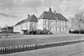
- Henkenshage was once a strong farmhouse, known as Strijpe or Streepe in the 14th century. In 1850, Peter Jacob Girard de Mielet van Coehoorn bought it and gave it its current look as a country estate. So, it's not a true castle, but a country house. During World War II, it was used as a distribution center. In 1944, during the liberation of Holland (Operation Market Garden), it served as the headquarters for the US 101st Airborne Division. Today, it is known as Kasteel Henkenshage and is used for weddings and events.
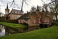
- Castle Dommelrode is a former castle built in 1605 by the sheriff of the Peelland area. For a long time, it was a monastery. Now, it is the town hall of Sint-Oedenrode.
- De Grote Laar is a farm that has existed since 1360. Its well belonged to the old castle De Laar, which is no longer there.
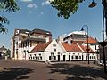
- De Markt is a market area that is wider at one end, almost like a square. It has a bandstand and is partly surrounded by grand houses. Some notable buildings include:
- Het Oude Raadhuis (The Old Town Hall) was built in 1863 as a large house for J.G. Raup. The municipality bought it in 1881 after the old town hall from 1691, which was in the middle of the market square, was taken down. A balcony and a tower were added to this building. However, it stopped being used as the town hall in 1963 when the town council moved to Castle Dommelrode. At the back of the house, there is a coach house with a 14th-century cellar from an older house called "Ten Kelre." On the side wall, there are plaques. One remembers the 2nd Regiment Hussars, a cavalry unit, stationed in Sint-Oedenrode during World War I mobilization. It also mentions their "Horse Doctors." This regiment was again in town in 1939. There is also a memorial for the 101st Airborne Division, made in 1985.
- The Giant Clog, located in the Dommel park on the Corridor, reminds everyone that Sint-Oedenrode was a major center for making wooden shoes (clogs). This clog was first made of wood, but because of damage, it was rebuilt using concrete.
- Coöperatieve Zuivelfabriek Sint-Oda is a building designed by Louis Kooken in 1916. It was a butter factory that used a steam engine and was in operation until 1979. Its chimney is a protected municipal monument.
- De Gouden Leeuw (The Golden Lion) is an inn that has been around since at least 1876.
Museums to Visit
Sint-Oedenrode has several museums and castles you can explore:
- Museum H.J. van de Kamp shows what an old forge (a place where metal is shaped) looked like in 1905.
- Museum Sint-Paulusgasthuis or Poffer- en mutsenmuseum is located in the old Sint-Paulus hospice. It has a herbal garden and a collection of traditional Brabantian poffers and headdresses.
- Museum Kasteel Henkeshage displays items related to the local nobility (important families).
- Museum Kasteel Dommelrode shows archaeological finds. These are items dug up in the Sint-Oedenrode area, mostly near the Hazenputten and the Everse Akkers.
- Jukeboxenmuseum Christ Boelens is a private museum that displays a collection of jukeboxes.
Fun Facts About Sint-Oedenrode
- Even though the town's full name is Sint-Oedenrode, local people often just call it "Rooi." The whole municipality, however, is still called Sint-Oedenrode.
- During the yearly carnaval celebration, the town's name changes to "Papgat" for three days. Sint-Oedenrode has 23 carnival groups!
- Every November, the arrival of Sinterklaas (a traditional Dutch figure similar to Santa Claus) is celebrated with a parade for the town's children.
- The language spoken by locals is North Meierijs. This is a type of East Brabantian dialect, which is very similar to everyday Dutch.
Awards and Recognition
In 2000, Sint-Oedenrode received the special Entente Florale award. This award recognized it as the greenest village in Europe.
Famous People From Sint-Oedenrode
- Els Coppens-van de Rijt, a painter and writer.
- Nikki Kerkhof, a singer who won the Dutch TV show Idols 4.
- Lou Tellegen, an actor.
- Ruud van der Rijt, a football (soccer) player for Willem II.
- Willem van Genugten, a legal expert.
Images for kids
-
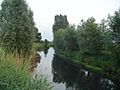
Dommel valley at Sint-Oedenrode
-
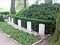
War graves at the cemetery of Sint-Oedenrode
-
Sint Paulus Hospice, 1434, Sint-Oedenrode
-
Henkenshage Castle as seen from the front
-
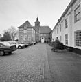
Castle Dommelrode, functioning as town hall of Sint-Oedenrode
-
Castle Dommelrode, other side
-
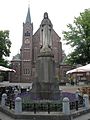
Statue in front of Sint Martinus Church, Sint-Oedenrode
-
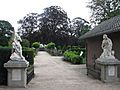
Entrance of cemetery, Sint-Oedenrode

.JPG)

.JPG)


.JPG)
.JPG)
See also
 In Spanish: Sint-Oedenrode para niños
