
Somaliland facts for kids
Quick facts for kids
Republic of Somaliland
|
|
|---|---|
 Emblem
|
|
|
Motto: لا إله إلا الله محمد رسول الله
Lā ilāhā illā-llāhu; muḥammadun rasūlu-llāh "There is no God but Allah; Muhammad is the Messenger of God" |
|
|
Anthem: Samo ku waar
حياة طويلة مع السلام "Live in Eternal Peace" |
|
.svg)
Territory controlled
Territory claimed but not controlled |
|
| Status | De facto state with limited recognition, recognised by one UN member state |
| Capital and largest city
|
Hargeisa 9°33′N 44°03′E / 9.550°N 44.050°E |
| Official languages | Somali |
| Second language | Arabic, English |
| Religion | Islam (official) |
| Demonym(s) | |
| Government | Unitary presidential republic |
| Abdirahman Mohamed Abdullahi | |
| Mohamed Aw-Ali Abdi | |
|
• Speaker of the House
|
Yasin Haji Mohamoud |
| Legislature | Parliament |
| House of Elders | |
| House of Representatives | |
| Unrecognised independence
from Somalia
|
|
|
• Isaaq Sultanate
|
1750–1884 |
|
• Establishment of British protectorate
|
1884 |
|
• Independence of the State of Somaliland from the United Kingdom
|
26 June 1960 |
|
• Union with the Trust Territory of Somaliland to form the Somali Republic
|
1 July 1960 |
|
• Somaliland War of Independence
|
6 April 1981 |
| 18 May 1991 | |
|
• Current constitution
|
13 June 2001 |
| Area | |
|
• Total
|
177,000 km2 (68,000 sq mi) |
| Population | |
|
• 2024 estimate
|
6,200,000 (109th) |
|
• Density
|
28.27/km2 (73.2/sq mi) |
| GDP (nominal) | 2022 estimate |
|
• Total
|
$3.782 billion |
|
• Per capita
|
$852 |
| Currency | Somaliland shilling |
| Time zone | UTC+3 (EAT) |
| Date format | d/m/yy (AD) |
| Driving side | right |
| Calling code | +252 (Somalia) |

Somaliland, officially known as the Republic of Somaliland, is a self-declared independent state in the Horn of Africa. It is located on the southern coast of the Gulf of Aden. Somaliland shares borders with Djibouti to the northwest, Ethiopia to the south and west, and Somalia to the east. Its claimed territory covers about 176,120 square kilometers. As of 2024, around 6.2 million people live there. The capital and largest city is Hargeisa.
Somaliland declared its independence in 1991. It sees itself as the successor to the former British Somaliland protectorate. Since then, it has had its own democratically elected governments. While many countries have not formally recognized Somaliland as an independent nation, it has informal ties with several foreign governments. On December 26, 2025, Israel formally recognized Somaliland as an independent state.
Contents
What's in a Name?
_(18411100885).jpg)
The name Somaliland comes from "Somali" and "land." Britain gave the area this name in 1884. This happened after they made agreements with local Somali clans. The British then created the Somaliland Protectorate.
In 1960, the protectorate became independent as the State of Somaliland. Five days later, it joined with the former Italian Somaliland. Together, they formed the Somali Republic. After a civil war in 1991, the region declared its independence again. It then adopted the name "Republic of Somaliland."
A Look Back in Time
Ancient Times

People lived in the Somaliland area about 10,000 years ago. They were ancient shepherds who raised animals. They also created amazing rock art paintings. The oldest burial sites in the Horn of Africa are found here. They date back to around 4,000 BCE.
The famous Laas Geel cave complex is near Hargeisa. Its rock art is about 5,000 years old. It shows wild animals and decorated cows. Other cave paintings in Dhambalin show early hunters on horseback. These artworks tell us a lot about ancient life.
Early Kingdoms and Trade
Ancient structures like pyramids and ruined cities show that advanced civilizations lived here. Ancient Somaliland traded with ancient Egypt and Mycenaean Greece. This trade happened as far back as 2,000 BCE. Many believe this area was the ancient Land of Punt.
People from Punt traded valuable goods like myrrh, spices, gold, and frankincense. They traded with Egyptians, Phoenicians, and Romans. The camel was likely first tamed in this region. This happened between 2,000 and 3,000 BCE.
The Arrival of Islam and Middle Ages

Many Somali Muslim kingdoms were formed in the area during early Islamic times. The Adal Sultanate, based in Zeila, was one of them. It fought against the Ethiopian Empire in the 14th century. Later, the Ottoman Empire controlled parts of the coast.
The Isaaq clan family grew and spread across Somaliland. They played a role in the Adal Sultanate's campaigns. The ruined city of Maduna in the Sanaag region shows Islamic history. Its mosque walls still stand 3 meters high.
Rise of Sultanates

In more recent history, new kingdoms appeared. These included the Isaaq Sultanate. This Somali kingdom ruled parts of the region in the 18th and 19th centuries. It was led by the Rer Guled branch of the Eidagale clan. The Sultanate was important before British rule.
Sultans would hold meetings called shirs. Here, elders and religious leaders would advise them. They helped manage grazing rights and new farming areas. They also worked to prevent conflicts between clans.
British Influence and Resistance
Britain began to engage with Somali clans in the 1800s. They signed treaties and established the British Somaliland protectorate in 1884. The British managed the area from Aden.
A long period of resistance followed, known as the Somaliland Campaign. From 1900 to 1920, the Dervishes, led by Mohammed Abdullah Hassan, fought against the British. The conflict ended in 1920 after British forces used airplanes to bomb the Dervish capital. This was a very difficult time for the region.
Local people also resisted British rule. In 1922, people in Burao protested a new tax. This led to a conflict where a British official was killed. The British responded by bombing the town. In 1945, Sheikh Bashir led another rebellion against British authorities. His forces fought the British for some time before he was killed.
Independence and Union

On June 26, 1960, British Somaliland became independent as the State of Somaliland. Just five days later, on July 1, 1960, it united with the former Italian Somaliland. Together, they formed the Somali Republic. Many people in the north were excited about this union at first.
However, problems soon arose. Many northerners felt that the new government favored the south. This led to widespread unhappiness. In December 1961, some British-trained officers from Somaliland tried to end the union. Their attempt failed, and the north felt ignored for many years.
A Difficult Period and New Independence

By the 1980s, many Somalis were unhappy with the military government. Resistance movements began to appear. The government responded with harsh actions, especially in the northern regions. Cities like Hargeisa and Burao were heavily damaged by bombing in 1988. Many people had to leave their homes and seek safety elsewhere. This was a very difficult time for the people of Somaliland.
,_1980s.jpg)
The Somali National Movement (SNM) was a key group fighting for change. The conflict caused immense suffering and destruction. The government of Somalia eventually collapsed in January 1991. After this, the people of Somaliland worked to rebuild their lives and communities.
Reclaiming Sovereignty

After the collapse of the Somali government, the SNM decided to pursue independence. At a conference in Burao in May 1991, the northwestern Somali territories declared their independence. This marked the restoration of Somaliland's sovereignty.
Leaders worked to establish peace and a new government. In 1993, Muhammad Haji Ibrahim Egal became president. He helped improve security and strengthen the new territory. In 2001, a referendum was held on a new constitution. A large majority of voters supported it, confirming Somaliland's self-declared independence.
How Somaliland is Governed
.png)
The Constitution and Leaders
Somaliland is a unitary state and a Presidential Republic. This means it has one central government and a president as its head. The government is based on peace, cooperation, and democracy. It also has a system with multiple political parties.
The country is led by an elected president. The president works with a vice-president and a Council of Ministers. These ministers help run the government every day. The president can serve for a maximum of two five-year terms.
Parliament and Laws

Somaliland has a Parliament with two parts. The upper house is called the House of Elders. Its members are chosen by local communities. The lower house is the House of Representatives. Its members are directly elected by the people. Both houses work together to pass laws.

The country's legal system has different levels of courts. These include district courts, regional courts, and a Supreme court. The Supreme Court is the highest court. It also acts as the Constitutional Court. Somaliland's laws are based on the 1962 penal code of the Somali Republic.
Political Parties and Elections
Somaliland has a multi-party democracy. There can be a maximum of three political parties at the national level. This system helps ensure that elections are based on ideas rather than just clan loyalties. People aged 15 and older can vote.
Somaliland has built a democratic government with little outside help. It has strong electoral and legislative systems. This has helped create a stable country.
Connecting with Other Nations

Somaliland has political contacts with its neighbors, Ethiopia and Djibouti. It also has ties with Taiwan, South Africa, Sweden, and the United Kingdom. On December 26, 2025, Israel formally recognized Somaliland as an independent state.
In 2007, the European Union (EU) sent a delegation to discuss future cooperation. The African Union (AU) has also discussed Somaliland's international recognition. In 2010, the United States said it would work more closely with Somaliland. It sent aid workers and diplomats to the region.

On July 1, 2020, Somaliland and Taiwan agreed to open representative offices. This helps promote cooperation between them. On January 1, 2024, Ethiopia and Somaliland signed an agreement. Ethiopia will lease part of the Port of Berbera in exchange for future recognition of Somaliland.
Border Challenges

Somaliland claims the entire area of the former British Somaliland. However, some areas in the east are disputed. Puntland, a federal state in Somalia, also claims some of this territory. This has led to conflicts between Somaliland and Puntland forces.
.jpg)
Local groups like the SSC Movement also formed. They wanted to create their own regional administration. In 2017, an agreement was signed to integrate one such group, Khatumo State, into the Somaliland government.
Protecting the Nation

The Somaliland Armed Forces are the country's main military. They work with the Somaliland Police to keep the country safe. After declaring independence, different clan militias joined to form a single army. This helped prevent conflicts between clans.
The army uses light weapons, howitzers, and rocket launchers. Its armored vehicles are mostly of Soviet design. Somaliland also has a navy, sometimes called a Coast Guard. It works to stop piracy and illegal fishing in its waters.
Human Rights Efforts
Somaliland is working to improve human rights for all its citizens. However, challenges remain, especially for minority groups. The government continues to make efforts to ensure fairness and protection for everyone.
Regions and Districts

Somaliland is divided into six main administrative regions. These are Awdal, Sahil, Maroodi Jeeh, Togdheer, Sanaag, and Sool. Each region is further divided into districts. The 2019 Local Government Act, which came into force on January 4, 2020, defines these divisions.
| Map | Regions | Area (km2) | Capital | Districts |
|---|---|---|---|---|
 |
||||
| Awdal | 16,294 | Borama | Baki, Borama, Zeila, Lughaya | |
| Sahil | 13,930 | Berbera | Sheikh, Berbera | |
| Maroodi Jeeh | 17,429 | Hargeisa | Gabiley, Hargeisa, Salahlay, Baligubadle | |
| Togdheer | 30,426 | Burao | Oodweyne, Buhoodle, Burao | |
| Sanaag | 54,231 | Erigavo | Garadag, El Afweyn, Erigavo, Lasqoray | |
| Sool | 39,240 | Las Anod | Aynabo, Las Anod, Taleh, Hudun |
Exploring Somaliland's Geography

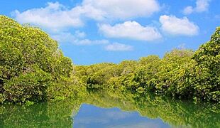
Somaliland is in the northwest of Somalia. It has an 850 km coastline along the Gulf of Aden. The country covers about 176,120 square kilometers.
The northern part of Somaliland is hilly, with altitudes up to 2,100 meters. The Awdal, Sahil, and Maroodi Jeeh regions are fertile and mountainous. Togdheer is mostly a dry, semi-desert area. The Awdal region also has beautiful offshore islands and coral reefs.
A coastal plain called the Guban runs along the Gulf of Aden. It is dry most of the year. But after the rains, it becomes green with lush plants. The Cal Madow is a mountain range in the east. It has Somaliland's highest peak, Shimbiris, which is about 2,416 meters high.
- Landscapes of Somaliland
-
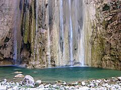
Lamadaya are waterfalls located in the Cal Madow mountain range.
-
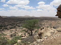
The Somaliland countryside
-
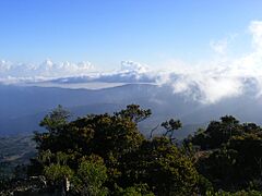
View of the Cal Madow Mountains, home to numerous endemic species
-
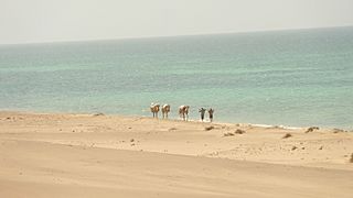
Berbera beach
-
Sacadin, Zeila Archipelago

(168).jpg)

_(2).jpg)

Somaliland's Climate

Somaliland has a semi-arid climate. This means it is generally dry. Average daily temperatures range from 25 to 35 degrees Celsius. The country has three main zones: a coastal plain (Guban), a coastal range (Ogo), and a plateau (Hawd).
The coastal plain has high temperatures and low rainfall. The Ogo range is a high plateau with more rainfall. The Hawd plateau is important for grazing livestock. Somalilanders recognize four seasons: Gu (spring rains), Hagaa (dry summer), Dayr (autumn rains), and Jiilaal (coolest, driest winter).
Wildlife of Somaliland
Somaliland is home to a variety of wildlife. Its diverse landscapes, from coastal areas to mountains, support different animal species.
Somaliland's Economy

Somaliland faces economic challenges. Many young people experience unemployment. Since it is not widely recognized, getting international aid can be difficult. The government mainly relies on taxes and money sent by Somalilanders living abroad. These remittances greatly help the economy.
Over the years, services like water, electricity, and education have improved. This is thanks to government efforts, aid groups, and the growing private sector. In 2014, Dahabshil Bank International became the country's first commercial bank.
Money and Payments

The Somaliland shilling is the country's currency. The Bank of Somaliland manages it. A popular way to pay for things is through the ZAAD service. This is a mobile money transfer service launched in 2009.
Communication
Several companies provide phone and internet services in Somaliland. These include Telesom and Somtel. The main national TV channel is Somaliland National TV, and Radio Hargeisa is its radio counterpart.
Farming and Livestock

Livestock farming is very important to Somaliland's economy. Sheep, camels, and cattle are shipped from the Port of Berbera to countries in the Middle East. Somaliland has some of the largest livestock markets in the Horn of Africa.
Agriculture also has potential, especially for growing cereals and vegetables. Most farming relies on rainfall. Sorghum and maize are the main crops. Fruits and vegetables are grown on irrigated farms for sale.
Tourism and Attractions
The Laas Geel rock art and caves are a popular tourist spot near Hargeisa. These ancient paintings are about 5,000 years old. The government works to protect them. Other sights include the Freedom Arch and the War Memorial in Hargeisa.
Natural landmarks like the Naasa Hablood (twin hills) are also popular. Historic towns like Sheekh and Zeila offer old colonial buildings and beautiful coastal views. The nomadic culture of Somaliland also attracts visitors.
Getting Around
Bus services operate in major cities like Hargeisa and Burao. Taxis, four-wheel drives, and minibuses connect towns and villages.

Daallo Airlines is a major airline serving Somaliland. African Express Airways and Ethiopian Airlines also offer international flights. The Egal International Airport in Hargeisa is a key airport. The Berbera Airport is another important one.
Ports and Trade

The Port of Berbera is a very important port. In 2016, the Somaliland government signed an agreement with DP World to manage and improve the port. This helps make it an important trade route for countries like Ethiopia.
Oil Exploration
Oil exploration has been happening in Somaliland. In 1958, the first test well was dug. It successfully produced light crude oil. In 2012, Genel Energy received a license to explore for oil. Studies have shown that there could be large oil reserves in the region. Drilling for oil began in late 2023 or early 2024.
People of Somaliland
There has not been an official census in Somaliland since 1975. However, estimates suggest the population was around 3.5 million in 2014. The Somaliland government estimates the population to be 6.2 million as of 2024.

The largest clan family in Somaliland is the Isaaq. They make up about 80% of the population. The Gadabuursi (part of the Dir clan) are the second largest. The Harti (part of the Darod clan) are also a significant group. Many Somalilanders also live abroad, especially in Europe, the Middle East, and North America.
Languages Spoken

Most people in Somaliland speak at least two languages. The official language is Somali. Arabic is taught in schools and used in mosques. English is also widely spoken and taught.
Somali is the native language of the Somali people. It belongs to the Cushitic language family. The main dialect spoken in Somaliland is Northern Somali.
Major Cities
- Hargeisa (Capital and largest city)
- Burao
- Berbera
- Gabiley
- Erigavo
- Las Anod
- Borama
- Oodweyne
- Zeila
- Sheikh
Religion and Beliefs

Almost all Somalilanders are Muslims. Most belong to the Sunni branch of Islam. Islam is very important to the Somali identity. Many social customs come from their religion. For example, most Somali women wear a hijab in public. Muslims gather for prayers and sermons on Friday afternoons.
Under the Constitution of Somaliland, Islam is the official religion. The country's laws follow Islamic principles. The government encourages Islamic values and traditions. There are very few Christians in Somaliland today.
Health and Well-being
Access to clean water is improving in Somaliland. However, many households still have to travel far to get drinking water. Sadly, about 1 in 11 children die before their first birthday. About 1 in 9 die before their fifth birthday. This shows the ongoing need for better healthcare.
Learning and Education

In 2015, a study showed that 59% of people in cities could read and write. In rural areas, this was 47%. Somaliland is working to improve education for all its citizens.
Somaliland's Culture
.jpg)
The main clan families in Somaliland are the Isaaq, Harti, and Dir. These groups are important social units. They play a central role in Somali culture and politics. Marriage often happens between people from different clans. This helps create strong family ties.
Arts and Creativity

Islam and poetry are very important parts of Somali culture. Somali poetry is often spoken aloud. Both men and women are poets. They use rich language and metaphors.
Celebrations often involve religious holidays. Two important ones are Eid ul-Adha and Eid ul-Fitr. Families dress up, visit each other, and give money to those in need. Other holidays celebrate Somaliland's independence.

Traditional arts include decorating woven and wooden items. Dance is also important, especially for young people. Henna art is a special tradition. Women decorate their hands and feet with beautiful henna designs for celebrations like Eid and weddings. Henna is also used by both men and women to dye their hair.
Sports and Games

Popular sports in Somaliland include football, track and field, and basketball. Somaliland has its own national football team.
See also
 In Spanish: Somalilandia para niños
- List of Somalilanders
- Outline of Somaliland
