
Berbera facts for kids
Quick facts for kids
Berbera
|
|||
|---|---|---|---|
|
City
|
|||
     |
|||
|
|||
| Country | |||
| Region | Sahil | ||
| District | Berbera District | ||
| Elevation | 3 m (10 ft) | ||
| Population
(2019)
|
|||
| • City | 542,344 | ||
| • Rank | 4th | ||
| • Urban | 978,000 | ||
| Demonym(s) | Barbaraawi بربراوي |
||
| Time zone | UTC+3 (EAT) | ||

Berbera is a very important city in Somaliland. It is the capital of the Sahil region. Berbera is also the main seaport for the country. It is about 160 km from Hargeisa, the national capital.
This coastal city used to be the capital of the British Somaliland protectorate. It was also a major port for several old kingdoms. These included the Ifat Sultanate, Adal Sultanate, and Isaaq Sultanate. They used the port from the 1200s to the 1800s.
In ancient times, Berbera was one of many busy port cities. These cities were along the Somali coast. They traded with places like Ancient Greece and the Roman Empire. Later, in the early modern period, Berbera became the most important trading spot in the Somali Peninsula.
From 1884 to 1941, Berbera was the capital of British Somaliland. Then, Hargeisa took its place. In 1960, British Somaliland became independent. Five days later, it joined with the former Italian Somalia to form the Somali Republic. Berbera is located on a key shipping route for oil. Its deep seaport is still the main commercial harbor for the region.
Contents
History of Berbera
Ancient Times
Berbera was part of the ancient Somali city-states. These states had a rich trade network. Somali merchants traded with many places, including Phoenicia and Ancient Greece. They used special boats called beden to carry their goods.
Berbera keeps the old name of the coast along the southern Gulf of Aden. People think it was the ancient port of Malao. This port was described in a Greek book from the first century AD. The book said Malao was a good market town. It was a place where people traded things like myrrh, frankincense, and slaves. They also imported clothes, copper, iron, and coins.
Middle Ages

A Chinese scholar named Duan Chengshi wrote about Berbera in 863 AD. He described its trade in slaves, ivory, and ambergris. Later, famous travelers like Ibn Sa'id and Ibn Battuta also mentioned the city in the 1200s.
In a book by Abu'l-Fida, the Gulf of Aden was called the Gulf of Berbera. This shows how important Berbera was for trade back then. The explorer Ahmad ibn Mājid also wrote about Berbera. He called the Gulf of Aden the Gulf of Berbera too. He listed other important ports along the northern Somali coast.
Berbera was a strong and well-built settlement. It was a major harbor for several Somali kingdoms. These included the early Adal Kingdom, Ifat Sultanate, and Adal Sultanate. Berbera and Zeila were the two most important ports in the Adal Sultanate. They helped connect the kingdom to the wider Islamic world.
Early explorers like Ludovico di Varthema and Duarte Barbosa wrote about Berbera in the 1500s. They mainly talked about its trade with Aden and Khambat in India. Duarte Barbosa noted that many ships from Aden and Cambay came to Berbera. They traded goods like gold, ivory, meat, honey, and wax.
Between 1516 and 1518, Portuguese ships attacked and looted Berbera and Zeila. Later, an Ottoman admiral named Selman Reis said Berbera was rich with pearls. He also mentioned that the amount of gold, musk, and ivory traded there was "limitless."
Before Colonial Rule

In 1801, Ibrahim Punkar wrote about Berbera. He said it had 5-6 towers with armed guards. He described the city's trade. Goods like cloth, rice, and tobacco came from India and Muscat. Dates and tin came from places like Mocha. Somali people in the area were skilled musketeers. They also had strong cavalry and were good at archery. Foreigners were not allowed to go further inland. This was to keep the valuable trade from Harar under Somali control.
For centuries, Berbera hosted a big annual fair. It took place from October to April. This fair was one of the most important trade events in East Africa. Somali clans, caravans from Harar, and Indian merchants came to trade.
Berbera was the most important port in the Somali Peninsula from the 1700s to the 1800s. It had strong trade links with ports in Arabia and India. The Somali and Ethiopian regions also relied on Berbera for trade. In 1833, the port town grew to 70,000 people during the trading season. Over 6,000 camels carrying goods arrived in a single day. Berbera was the main market for many goods from inland. These included livestock, coffee, frankincense, and gold.
A trade journal in 1856 called Berbera "the freest port in the world." It was also called "the most important trading place on the whole Arabian Gulf." The journal noted that caravans with 6,000 camels came from inland. They brought coffee, gum, ivory, and hides.

Historically, the mercantile Reer Ahmed Nur and Reer Yunis Nuh clans controlled the port of Berbera. They managed all trade and protected foreign traders. In 1845, these two clans had a disagreement over trade control. This led to a fight. The Reer Ahmed Nuh clan won and became the sole trade masters of Berbera. The defeated Reer Yunis Nuh moved west. They started the port of Bulhar, which competed with Berbera for a short time.
Berbera handled most of the trade with the Somali and Ethiopian interiors. The main trade routes went to Harar and Shewa. Some caravans even went as far as the Jubba River. These routes were also used by Somali pilgrims traveling for Hajj.

Ports in Arabia, like Mocha and Aden, traded constantly with Berbera. In the early 1800s, the local Somalis had a rule. They did not allow Arab ships in their ports. Instead, they carried goods to Arabian ports in their own ships.
Trade between Berbera and Aden was very important. If trade in Berbera slowed down, Aden also suffered. In 1848, 80% of Aden's income came from goods imported from Berbera. Most of the coffee in Mocha came from Somali merchants in Berbera. Even though the coffee grew in Harar, it was called Berbera Coffee in the international market.
.jpg)
The British explorer Richard Francis Burton visited Berbera twice. On his second visit, his camp was attacked. He escaped to Aden, but one of his friends was killed. Burton understood how important the port was. He called Berbera "the true key of the Red Sea." He said it was the main center for East African trade.
Battle of Berbera (1827)
In 1825, a British ship called the Mary Anne was attacked in Berbera's port. Many crew members were killed. The Royal Navy blocked the port in response. Some say they even bombed the city. In 1827, the British offered to lift the blockade. They asked for money to cover the damage to the ship and lives lost. This led to the Battle of Berbera 1827. After the local Habr Awal clan lost, they had to pay 15,000 Spanish dollars.
In the 1830s, the Isaaq Sultan Farah Guled asked Sultan bin Saqr Al Qasimi for military help against the British. But Sultan Saqr could not send aid. The Qasimi people were active in the Gulf of Aden. They often attacked ships. They also had strong trade ties with the Somalis.
British Somaliland

From 1884 to 1886, the British signed treaties with Somali clans. They then set up a protectorate called British Somaliland. The British managed it from their colony in Aden.
Even though Berbera was important, the British later had doubts about controlling the region. Winston Churchill visited Berbera in 1907. He thought the protectorate should be given up. He called it "unproductive" and said the people were "very hostile." The British mainly wanted the protectorate to get meat supplies for Aden. They also wanted to keep trade routes safe. The British did not build much infrastructure beyond the coast. This gave Somali clans more freedom.

In August 1940, during World War II, Italy briefly took over British Somaliland. The British evacuated soldiers and officials through Berbera. About 7,000 people, including civilians, were evacuated. In March 1941, British forces took back the protectorate.
British Somaliland became independent on June 26, 1960. It was called the State of Somaliland. Five days later, it joined with the former Italian Somalia to form the Somali Republic.
Modern Times

After independence, Berbera was part of the North-Western province of the Somali Republic. It was the main port for exporting livestock. In the 1970s and 1980s, most livestock exports went through Berbera. These exports made up over 90% of the Somali Republic's total exports. Berbera's exports alone brought in over 75% of the country's foreign money. The main buyers were rich countries in the Gulf, especially Saudi Arabia.
In 1962, the Soviet Union helped build modern port facilities and a military base in Berbera. This was finished in 1969. In 1977, during the Ogaden War, the Soviets left Berbera. Then, the United States invested $40 million in the port in 1980. By 1985, Berbera had about 70,000 people. The Somali National Movement fought government troops in the city. After the government fell in 1991, the northern region declared itself the state of Somaliland. Berbera then slowly began to rebuild.

Berbera is still an important regional port. In 2016, DP World and the government of Somaliland made a $442 million deal. This deal is to improve and operate the Port of Berbera. The project also includes setting up a free zone.
On March 1, 2018, Ethiopia became a major owner of the project. This happened after an agreement with DP World and the Somaliland Port Authority. DP World owns 51%, Somaliland 30%, and Ethiopia 19%. Ethiopia will also invest in roads to make the Berbera Corridor a trade route. There are plans to build another dock at the port.
On June 24, 2021, DP World announced the second phase of the port upgrade. This phase will make the new dock longer, from 400 to 1,000 meters. It will also add more cranes. This will allow the port to handle up to two million containers a year.
This agreement is part of a larger deal between the United Arab Emirates and Somaliland. Somalia tried to stop the deal but failed. A rail link to Addis Ababa, Ethiopia's capital, is also being discussed. On January 1, 2024, Ethiopia signed an agreement to use Berbera's seaport.
Geography
Location and Environment
_(2).jpg)
Berbera is on the coast of northern Somalia. It is an old port city. It has the only sheltered harbor on the southern side of the Gulf of Aden. The land around Berbera is dry or semi-dry.
The city has popular beaches like Bathela and Batalale. Because of these, Berbera is sometimes called Beach City.
Climate
Berbera has a hot desert climate. It has long, very hot summers and short, hot winters. There is very little rain. Average high temperatures are often above 40°C (104°F) for almost four months in summer. Even at night in summer, it stays hot, around 30°C (86°F). In the coolest months, high temperatures are still above 29°C (84°F). Low temperatures are above 20°C (68°F).
Even though there is little rain, the air is very humid all year. The mix of desert heat and high humidity makes it feel extremely hot. The city gets only about 52 mm (2 inches) of rain each year. It rains on average 5 to 8 days a year. The sun shines for about 84% of the daytime hours. There are very few clouds.
| Climate data for Berbera | |||||||||||||
|---|---|---|---|---|---|---|---|---|---|---|---|---|---|
| Month | Jan | Feb | Mar | Apr | May | Jun | Jul | Aug | Sep | Oct | Nov | Dec | Year |
| Record high °C (°F) | 35.3 (95.5) |
35.0 (95.0) |
35.0 (95.0) |
42.2 (108.0) |
47.3 (117.1) |
49.1 (120.4) |
47.7 (117.9) |
46.7 (116.1) |
46.0 (114.8) |
41.7 (107.1) |
36.7 (98.1) |
36.1 (97.0) |
49.1 (120.4) |
| Mean daily maximum °C (°F) | 27.9 (82.2) |
29.2 (84.6) |
30.7 (87.3) |
31.0 (87.8) |
35.7 (96.3) |
42.8 (109.0) |
42.9 (109.2) |
41.9 (107.4) |
39.7 (103.5) |
33.1 (91.6) |
30.0 (86.0) |
28.6 (83.5) |
34.5 (94.1) |
| Daily mean °C (°F) | 25.0 (77.0) |
25.0 (77.0) |
26.1 (79.0) |
28.3 (82.9) |
31.1 (88.0) |
33.5 (92.3) |
36.1 (97.0) |
35.6 (96.1) |
33.3 (91.9) |
28.8 (83.8) |
26.7 (80.1) |
26.7 (80.1) |
30.0 (86.0) |
| Mean daily minimum °C (°F) | 21.3 (70.3) |
21.6 (70.9) |
23.3 (73.9) |
25.2 (77.4) |
27.7 (81.9) |
31.0 (87.8) |
31.8 (89.2) |
31.1 (88.0) |
29.3 (84.7) |
24.0 (75.2) |
22.2 (72.0) |
21.6 (70.9) |
25.8 (78.4) |
| Record low °C (°F) | 14.4 (57.9) |
15.6 (60.1) |
16.7 (62.1) |
18.9 (66.0) |
20.6 (69.1) |
22.2 (72.0) |
20.6 (69.1) |
20.0 (68.0) |
17.8 (64.0) |
16.7 (62.1) |
16.1 (61.0) |
15.0 (59.0) |
14.4 (57.9) |
| Average rainfall mm (inches) | 8 (0.3) |
2 (0.1) |
5 (0.2) |
12 (0.5) |
8 (0.3) |
1 (0.0) |
1 (0.0) |
2 (0.1) |
1 (0.0) |
2 (0.1) |
5 (0.2) |
5 (0.2) |
52 (2.0) |
| Average rainy days (≥ 1.0 mm) | 0.6 | 0.6 | 0.5 | 0.7 | 0.8 | 0.1 | 0.3 | 0.5 | 0.4 | 0.2 | 0.3 | 0.4 | 5.2 |
| Average relative humidity (%) | 78 | 79 | 79 | 81 | 73 | 49 | 44 | 45 | 51 | 72 | 74 | 76 | 67 |
| Percent possible sunshine | 80 | 80 | 80 | 83 | 83 | 87 | 80 | 87 | 87 | 87 | 87 | 80 | 83 |
| Source 1: Arab Meteorology Book (average temperatures, humidity and precipitation), Deutscher Wetterdienst (precipitation days, 1908–1950 and extremes) | |||||||||||||
| Source 2: Food and Agriculture Organization: Somalia Water and Land Management (percent sunshine) | |||||||||||||
People of Berbera

Most people living in Berbera are from the Somali ethnic group. Specifically, many are from the Isamusa clan. This clan is a sub-clan of the Isaaq.
Education
Berbera city has 30 primary schools. These schools teach a total of 63,641 students. The larger Berbera district has 49 schools. These schools serve 90,310 students.
Economy
Many products are shipped out through the Port of Berbera. These include livestock, gum arabic, frankincense, and myrrh. Berbera mainly trades by sea with Jeddah in Saudi Arabia and Aden in Yemen. Aden is about 240 km to the north. Goods from Ethiopia are also shipped through the port. The seaside is popular for water sports. You can go scuba diving, snorkeling, and surfing. There are also beautiful coral reefs.
Transportation

Berbera is at the end of roads from Hargeisa and Burco. The city has one of Somaliland's main seaports, the Port of Berbera. It used to be a naval and missile base for the Somali government. In 1962, the Soviet Union helped upgrade the port. Later, the United States also expanded the port for military use.
For air travel, the city has the Berbera Airport. It has a very long runway, about 4,140 meters (13,580 feet) long.
Images for kids
-
Somalis kept the interior free of foreigners and restricted their access to only Berbera itself
-
Berbera's inhabitants proficiency with muskets, possession of a large cavalry and archery skills noted
-
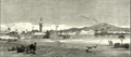
Illustration of Berbera, 1884
-

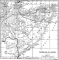
Map showing Berbera and her trade routes, with the 'Ayal Achmet' (Reer Ahmed Nuh) located in Berbera and its environs
-
1911 map showing Italian Somaliland and British Somaliland, including Berbera
-
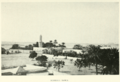
Part of Berbera town in 1912
-
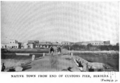
Bebrera native town as seen from the customs pier


