
Southern Lakes (New Zealand) facts for kids

The Southern Lakes is a special area in the southern part of New Zealand's South Island. Even though it's not an official region, many groups like the New Zealand weather service use this name. This area includes parts of Southland (like Fiordland) and Central Otago. Sometimes, it also includes the Mackenzie Basin in Canterbury. The whole area is huge, covering about 28,000 to 35,000 square kilometers.
This region does not have many people living in it. A large part of its southwestern area is an empty national park. Much of the beautiful scenery here was shaped by glaciers during the last ice age. This means you can see many wide, U-shaped valleys. Several of these valleys are now filled with big lakes. These lakes include Lake Hauroko, which is New Zealand's deepest lake. The Southern Lakes also contain three of the country's four largest lakes. If you include the Mackenzie Basin, then seven of New Zealand's ten biggest lakes are found here.
Many of the lakes in this region feed into the Clutha River, which is New Zealand's second-longest river. Lakes like Wakatipu, Wānaka, and Hāwea are part of the Clutha River system. There are also artificial lakes like Dunstan and Roxburgh. These were made by hydroelectric dams that create electricity from water. Other lakes, such as Te Anau and Manapouri, feed into the Waiau River system. The lakes in the northern Mackenzie Basin are part of the Waitaki River system.
The main towns in the Southern Lakes area are Queenstown and Wānaka in Otago. Another important town is Te Anau in Southland.
Discover the Lakes

Here is a list of the largest lakes in the Southern Lakes region. These lakes all have a surface area bigger than 20 square kilometers. Some lakes listed as being in Canterbury are sometimes not included when people talk about the Southern Lakes.
| Rank | Name | Surface area | Region | Fun Facts |
|---|---|---|---|---|
| 1 | Lake Te Anau | 344 km2 (133 sq mi) | Southland | This is the largest lake in the South Island and the second largest in all of New Zealand. |
| 2 | Lake Wakatipu | 291 km2 (112 sq mi) | Otago | It's famous for its unique zigzag shape. |
| 3 | Lake Wānaka | 192 km2 (74 sq mi) | Otago | A popular spot for water sports and outdoor adventures. |
| 4 | Lake Pukaki | 179 km2 (69 sq mi) | Canterbury | Known for its stunning bright blue color. |
| 5 | Lake Manapouri | 142 km2 (55 sq mi) | Southland | Often called the "Lake of Many Islands." |
| 6 | Lake Hāwea | 141 km2 (54 sq mi) | Otago | A long, narrow lake perfect for fishing and boating. |
| 7 | Lake Tekapo | 83 km2 (32 sq mi) | Canterbury | Famous for its clear night skies and the Church of the Good Shepherd. |
| 8 | Lake Hauroko | 63 km2 (24 sq mi) | Southland | This is New Zealand's deepest lake! |
| 9 | Lake Ōhau | 63 km2 (24 sq mi) | Canterbury | A beautiful lake surrounded by mountains. |
| 10 | Lake Poteriteri | 43 km2 (17 sq mi) | Southland | One of the more remote and untouched lakes. |
| 11 | Lake Monowai | 31 km2 (12 sq mi) | Southland | A peaceful lake in a forested area. |
| 12 | Lake McKerrow | 28 km2 (11 sq mi) | Southland | Located in a beautiful fiordland setting. |
| 13 | Lake Dunstan | 26 km2 (10 sq mi) | Otago | This lake was created by a dam and is popular for recreation. |
Other interesting lakes in the area include the Mavora Lakes in Southland. There is also Lake Hayes in Otago, and the artificial Lake Ruataniwha. Lake Ruataniwha is located near the border between Canterbury and Otago.
Images for kids
-
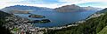
Panorama of Queenstown and Lake Wakatipu
