St Giles, London facts for kids
Quick facts for kids St Giles |
|
|---|---|
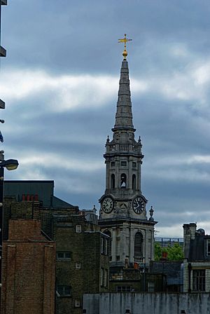 The parish church of St Giles in the Fields |
|
| OS grid reference | TQ300811 |
| • Charing Cross | 0.5 mi (0.8 km) S |
| London borough | |
| Ceremonial county | Greater London |
| Region | |
| Country | England |
| Sovereign state | United Kingdom |
| Post town | LONDON |
| Postcode district | WC1, WC2 |
| Dialling code | 020 |
| Police | Metropolitan |
| Fire | London |
| Ambulance | London |
| EU Parliament | London |
| UK Parliament |
|
| London Assembly |
|
St Giles is a historic area in the West End of London, located within the London Borough of Camden. It is named after its famous church, St Giles in the Fields. For a long time, St Giles and the nearby area of Bloomsbury were managed together. This is why St Giles is often thought of as part of Bloomsbury.
Some interesting places to visit in St Giles include the church of St Giles in the Fields, the unique area of Seven Dials, the peaceful Phoenix Garden, and the busy crossroads known as St Giles Circus.
Contents
A Look Back: The History of St Giles
There has been a church in the St Giles area since very old Saxon times. It was built right next to a major road, making it an important spot.
Early Days: The Hospital and Village
Around the year 1120, a special hospital called Hospitali Sancti Egidii extra Londonium was started by Queen Matilda, who was married to King Henry I. This hospital also had a monastery and a chapel. St Giles (who lived around 650-710 AD) was known as the patron saint of people with leprosy. So, the hospital was a place for people with this disease. It was built in the fields and marshes away from London to keep the illness from spreading. Over time, a small village grew up around the hospital to serve the patients and monks.
The Crossroads and Its Past
The busy crossroads we now call St Giles Circus was once a place where public executions happened until the 1400s. A famous leader named Sir John Oldcastle was executed there. Interestingly, Grape Street, which is in the heart of St Giles, runs next to where the hospital's vineyard used to be.
Changes and Challenges
During the Reformation, the monastery was closed down. The chapel then became a parish church. The hospital continued to care for people with leprosy until the mid-1500s. After that, it started helping poor people instead. The area became known as St Giles in the Fields.
By the mid-1600s, many poor people began moving into the parish. Records show that cellars were often used as homes for entire families. These places were described as "damp and unwholesome" because the village was built on marshy land. The area was known for offering help to those in need, which attracted many people. Irish and French refugees also settled here, as did "St Giles blackbirds," a term for Black servants who had become beggars.
The Great Plague and New Beginnings
The terrible Great Plague of 1665 actually started in St Giles. The first victims were buried in the St Giles churchyard. By September 1665, about 8,000 people were dying each week in London. St Giles parish, which had fewer than 2,000 homes, recorded 3,216 plague deaths that year.
After the plague, many Huguenot refugees, who had escaped persecution, moved to the area. They became skilled workers and tradesmen, especially in weaving and silk.
The southern part of the parish, now near Shaftesbury Avenue, was once an empty area called Cock and Pye Fields. Houses were built there after the Great Fire of London in 1666, and the area was fully developed by 1693, becoming known as Seven Dials. Thomas Neale built much of this area, and streets like Neal Street and Neal's Yard are named after him. St Giles and Seven Dials became famous for people who studied stars and practiced alchemy, a connection that still exists today.
St Giles village was on the main road from Holborn to Tyburn, where executions took place. It was a tradition for people being taken to Tyburn to stop at St Giles for a final drink, called a "St Giles Bowl," before their execution.
The Rookery: A Crowded Neighborhood
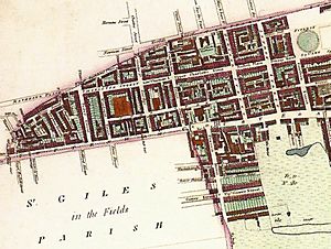
The area known as the "rookery" was a five-acre plot in the northwest of the parish. It was bordered by Great Russell Street to the north, Tottenham Court Road to the west, St Giles High Street to the south, and Dyott Street to the east. Today, the Centrepoint homeless charity and Google have offices on this site.
In the late 1600s, the land was owned by the Bainbridge family, who created roads and leased plots to builders. These builders often put up many lodging houses close together. By the 1700s, the area had become run-down. This was made worse by the landowner's debts and long leases that gave builders no reason to improve the old houses.
The rookery was known as one of the worst slums in Britain. It was often described as being very crowded and dirty, a messy maze of buildings. It had a large Irish Catholic population and was sometimes called "Little Ireland" or "The Holy Land." As London grew, so did the population of St Giles, reaching 30,000 people by 1831. Many Irish migrants escaping the Great Famine (Ireland) between 1845 and 1849 moved to the parish.
The phrase "a St Giles cellar" became a common way to describe the worst living conditions. Open sewers often ran through rooms, and waste pits were not properly cared for. In 1849, residents complained to the Times newspaper, saying they lived in "muck and filth" and had no proper toilets or water supply. The rookery was a confusing network of small shops and secret alleyways, making it hard for police to navigate. Many artists and writers, like William Hogarth and Charles Dickens, featured the area in their works. Historian Peter Ackroyd wrote that the Rookeries showed "the worst living conditions in all of London's history."
A reformer named Henry Mayhew described the slum in 1860:
The parish of St. Giles, with its nests of close and narrow alleys and courts inhabited by the lowest class of Irish costermongers, has passed into a byword as the synonym of filth and squalor. And although New Oxford Street has been carried straight through the middle of the worst part of its slums—"the Rookery"—yet, especially on the south side, there still are streets which demand to be swept away in the interest of health and cleanliness... They [are] a noisy and riotous lot, fond of street brawls, equally "fat, ragged and saucy"; and the courts abound in pedlars, fish-women, newscriers, and corn-cutters.
Because of high death rates, especially from diseases like cholera and tuberculosis, the churchyard ran out of burial space. Many people were buried in cemeteries around St Pancras during the 1700s and 1800s.
From the 1830s to the 1870s, there were plans to tear down the slum as part of larger London projects to improve transport, sanitation, and expand railways. New Oxford Street was built right through the slum, connecting Oxford Street and Holborn. This pushed the slum further south into Seven Dials, which then became even more run-down. Plans for a complete cleanup were delayed until the end of the century due to the area's unchanging nature, failed investment plans, and difficulty selling new properties.
Local Government Over Time
St Giles seems to have been part of the Holborn parish when St Giles hospital was founded in the early 1100s.
It's not clear exactly when the Ancient Parish of St Giles was officially formed. Some records suggest it was before 1222, while others say 1547. From 1597 onwards, English parishes had to take on both religious and civil duties, starting with helping the poor.
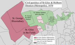
The parish was part of the Ossulstone hundred in Middlesex. The parish of St George Bloomsbury was separated in 1731. However, for civil purposes, the parishes were combined again in 1774. They were used to manage the Poor Law after the Poor Law Amendment Act 1834.
In 1855, when the Metropolitan Board of Works was created, the combined parishes became the St Giles District (Metropolis). In 1889, they became part of the County of London.
The St Giles parish was shaped like a long "L," stretching from Torrington Place in the north to Shelton Street in the south, and then east to include Lincoln's Inn Fields. For record-keeping and census reports, the civil parish was divided into North and South districts, with Monmouth Street generally forming the boundary. In 1881, the population of St Giles North was 13,837, and St Giles South was 14,864.
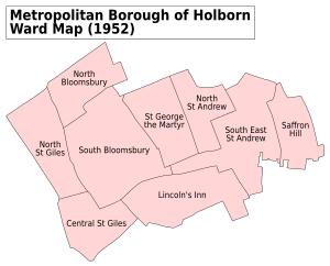
In 1900, London's local government was reorganized, and St Giles became part of the Metropolitan Borough of Holborn. Since 1965, it has been part of the London Borough of Camden.
Street Names and Their Meanings
St Giles doesn't have official borders, but it generally forms a triangle. This area is bordered by New Oxford Street to the north, Shaftesbury Avenue to the southeast, and Charing Cross Road to the west. Many streets in St Giles are named after important people or places from its history:
- Brook Mews
- Bucknall Street – Named after either Arabella Bucknall (or Bucknell), whose family owned land here, or Ralph Bucknall, a local church official in the 1600s-1700s.
- Cambridge Circus – Named after Prince George, 2nd Duke of Cambridge. He officially opened the new Charing Cross Road development in 1887.
- Charing Cross Road – Built in 1887, it leads to the cross at Charing. The name "Charing" comes from an old English word meaning a bend in the River Thames.
- Denmark Place and Denmark Street – Named after Prince George of Denmark, who was married to Queen Anne.
- Dyott Street – Named after either Simon Dyott, a local resident in the 1600s, or Jane Dyott, whose father Henry Bainbridge owned land nearby.
- Earnshaw Street – Named after Thomas Earnshaw, a famous watchmaker from the 1700s-1800s who worked close by.
- Flitcroft Street – Named after Henry Flitcroft, the architect who designed the St Giles in the Fields church.
- New Compton Street – Like Old Compton Street, it is thought to be named after Henry Compton, who was the Bishop of London in the 1670s.
- New Oxford Street – Built between 1845 and 1847 as an extension of Oxford Street.
- Phoenix Street – Named after an old inn that used to be in the area.
- Princes Circus
- St Giles Circus, St Giles High Street, and St Giles Passage – All named after St Giles Hospital. This hospital for people with leprosy was founded by Matilda of Scotland, wife of King Henry I, in 1117. St Giles was a hermit from the 700s who became the patron saint of people with disabilities and leprosy. A "Circus" in Britain means a road junction where several roads meet around a central island.
- Shaftesbury Avenue – Named after Anthony Ashley Cooper, 7th Earl of Shaftesbury, a Victorian politician and helper of others.
- Stacey Street – Named after John Stacey, who owned land in the area in the 1500s.
St Giles Today: Modern Governance
St Giles is divided between two electoral areas in the London Borough of Camden: Bloomsbury and Holborn and Covent Garden. Along with parts of Holborn and Bloomsbury, it is part of the "Midtown" business improvement district. It is also within the Holborn and St Pancras area for Parliament and the Barnet and Camden area for the London Assembly.
Tottenham Court Road Tube Station
The Central London Railway (CLR) opened Tottenham Court Road Tube Station on July 30, 1900. It is located between the Church of St Giles in the Fields and St Giles Circus. In the early 1930s, the station was updated, replacing lifts with escalators. The station had four entrances around St Giles Circus and a subway from the Centrepoint building. These entrances often became very crowded, sometimes needing to be closed during busy times to prevent too many people from entering the station.
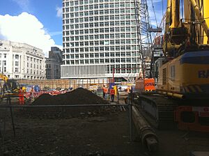
In 2009, Transport for London began a big project to rebuild much of the station. A large part of the St Giles area along St Giles High Street was cleared for this new development, which included the Crossrail expansion. The Astoria theatre on Charing Cross Road was taken down, and the original Central line entrances will also be removed.
Business in St Giles
Together with Bloomsbury and Holborn, St Giles is part of the "Midtown" business improvement district. This means businesses in the area work together to improve the local environment and economy.
See also
- Church of St Giles in the Fields
- St Giles Circus
- St Giles District (Metropolis)
- Central Saint Giles
- The Phoenix Garden
 | Dorothy Vaughan |
 | Charles Henry Turner |
 | Hildrus Poindexter |
 | Henry Cecil McBay |


