
Telluride, Colorado facts for kids
Quick facts for kids
Telluride, Colorado
|
|
|---|---|

Colorado Avenue: As seen from The New Sheridan Hotel
|
|

Location of Telluride in San Miguel County, Colorado
|
|
| Country | United States |
| State | Colorado |
| County | San Miguel County, Colorado – seat |
| Founded | 1878 |
| Incorporated | February 10, 1887, as Columbia |
| Government | |
| • Type | Home rule municipality |
| Area | |
| • Total | 2.22 sq mi (5.76 km2) |
| • Land | 2.22 sq mi (5.76 km2) |
| • Water | 0.00 sq mi (0.00 km2) |
| Elevation | 8,754 ft (2,668 m) |
| Population
(2020)
|
|
| • Total | 2,607 |
| • Density | 1,172/sq mi (452.6/km2) |
| Time zone | UTC−7 (MST) |
| • Summer (DST) | UTC−6 (MDT) |
| ZIP code |
81435
|
| Area code(s) | 970 |
| FIPS code | 08-76795 |
| GNIS feature ID | 2413371 |
| Website | Town of Telluride |


Telluride is a beautiful town in the southwestern part of Colorado, USA. It is the main town and county seat of San Miguel County. Long ago, Telluride was a busy silver mining town. It sits by the San Miguel River in the western San Juan Mountains. The first gold was found here in 1875, and the town officially started in 1878.
Telluride is located in a deep valley called a box canyon. Tall, tree-covered mountains and cliffs surround it. Bridal Veil Falls, a stunning waterfall, is at the end of the canyon. You can still see old mining buildings on the hillsides. A free gondola connects Telluride to its nearby town, Mountain Village, which is at the base of the ski area.
Telluride is famous for its amazing ski resort in winter. In summer, it hosts many fun events, like the Hot Air Balloon Festival. A large part of the town, called the Telluride Historic District, is listed as a special historic place. It is also one of Colorado's 20 National Historic Landmarks. In 2020, about 2,607 people lived in Telluride.
Contents
Telluride's History

Mining Days
Gold was first found in Colorado in 1858, starting a big gold rush. In 1875, gold was also found in the mountains above Telluride and in the San Miguel River. John Fallon made the first claim in Marshal Basin in 1875. The town of Telluride began in 1878. It was first called "Columbia," but its name was changed in 1887 to avoid confusion with another town in California.
The town was named after special minerals called tellurides. These minerals contain the element tellurium. Even though gold telluride minerals were not found here, the mines were rich in zinc, lead, copper, silver, and other forms of gold.
Telluride grew slowly at first because it was so far away. In 1881, a special road was built by Otto Mears. This road allowed wagons to reach the town, making it easier to bring in supplies and take out valuable ore.
In 1889, a famous outlaw named Butch Cassidy robbed the San Miguel Valley Bank in Telluride. This was one of his first big crimes. He stole a lot of money and later became a well-known bank robber.
In 1891, the Rio Grande Southern railroad reached Telluride. This railroad, also started by Otto Mears, made transportation much cheaper and faster. Miners and goods could easily come into town, and ore could be sent out to processing plants. This led to a short but big boom for Telluride.
Around 1900, there were many disagreements between miners and mine owners. Miners wanted better pay and safer conditions. They formed unions to fight for their rights. In 1899, many mines agreed to pay miners $3 a day for an 8-hour workday. Before this, miners often worked 10 to 12 hours a day in very dangerous conditions. The mines were high up, over 12,000 feet, and winters were harsh.

In 1891, a man named L.L. Nunn from Telluride worked with George Westinghouse. They built the Ames Hydroelectric Generating Plant near Telluride. This was a power plant that used water to create electricity. It was the first successful plant to send industrial-grade electricity over a long distance. This plant powered the Gold King Mine, 3.5 miles away. It was built four years before the famous Westinghouse plant at Niagara Falls. L.L. Nunn also started educational programs and founded Deep Springs College.
Telluride's most famous historic mines were the Tomboy, Pandora, Smuggler-Union, Nellie, and Sheridan mines. Mining continued until 1978. When the mines closed, the town found a new way to make money: skiing and tourism. The snow that made mining hard now brought visitors to the town.

The Skiing Era
Mining was Telluride's only industry until 1972. That year, the first ski lift was built by Telluride Ski Resort founder Joseph T. Zoline. He bought land for the resort in 1969 and started planning the ski slopes. As mining ended, new jobs in tourism began. Many mining families moved away, and new people came to Telluride. These newcomers enjoyed the outdoor lifestyle, like hang gliding and mountain climbing.
At first, some people in town didn't want too much growth from tourism. But the town's famous music and film festivals grew very popular. These festivals brought many visitors who saw how beautiful the valley was. Meanwhile, Joe Zoline worked to create one of the best ski mountains in North America.

After a tough winter in 1976 with little snow, the town's economy started to improve. In 1978, Ron Allred and Jim Wells bought part of the ski area. They built a gondola to connect Telluride with Mountain Village.
In the 1980s, Telluride became known as "Colorado's best kept secret." This made it even more popular. Wealthy skiers came in winter, and sightseers filled hotels in summer. Telluride also gained a reputation for its "Wild West" feel. This helped it stand out from other resort towns. Celebrities like Tom Cruise and Oprah Winfrey visited.
By the mid-1990s, Telluride had become a top resort town. It balanced modern culture with its interesting western history. In 2003, the ski area expanded with new trails. In 2007–08, even more challenging ski terrain was opened. Most ski lifts are fast quad chairs, holding four people. The highest lift on the mountain reaches an elevation of 12,570 feet.

Telluride's Location
Telluride is located high up at about 8,750 feet (2,667 meters) in a quiet part of Southwest Colorado. The most common way to get to Telluride is by Colorado Route 145. There are also two other mountain passes, Imogene Pass and Black Bear Pass, but these are more challenging.
On the east side of town, you can see Ingram Falls. Just beyond that is Bridal Veil Falls and the Bridal Veil Hydroelectric plant. This power plant was built in 1895 to power a mine.
The town has its own airport, Telluride Regional Airport (TEX). It used to be the highest commercial airport in the United States. Pilots find it challenging because of bad weather, high elevation, and the rugged mountains around it. Many people fly into Montrose (MTJ), which is about 70 miles north by road, and then drive to Telluride.
Population Information
| Historical population | |||
|---|---|---|---|
| Census | Pop. | %± | |
| 1890 | 766 | — | |
| 1900 | 2,446 | 219.3% | |
| 1910 | 1,756 | −28.2% | |
| 1920 | 1,618 | −7.9% | |
| 1930 | 512 | −68.4% | |
| 1940 | 1,337 | 161.1% | |
| 1950 | 1,101 | −17.7% | |
| 1960 | 677 | −38.5% | |
| 1970 | 553 | −18.3% | |
| 1980 | 1,047 | 89.3% | |
| 1990 | 1,309 | 25.0% | |
| 2000 | 2,221 | 69.7% | |
| 2010 | 2,325 | 4.7% | |
| 2020 | 2,607 | 12.1% | |
| U.S. Decennial Census | |||

Getting Around Telluride
Telluride has a local airport, Telluride Regional Airport. However, flights can be limited due to the short runway and frequent bad weather. Most visitors fly into Montrose Regional Airport, which is about 67 miles north.
Telluride offers free public transportation. The bus system, called Galloping Goose, travels in a loop around the town. A special gondola lift connects Telluride with Mountain Village.
Telluride's free gondola is unique in North America. It has four stops: Telluride, St. Sophia, and two stops in Mountain Village. It was built to help people get around without needing a car. The ride takes about 13 minutes and reaches a high point of 10,540 feet (3,213 meters) at the San Sophia station.
Regional bus service is also available through the San Miguel Authority for Regional Transportation (SMART). Telluride is part of Colorado's Bustang bus service network, connecting it to other towns.
Main Roads
 State Highway 145 is a scenic road that is part of the San Juan Skyway Scenic and Historic Byway. It links Telluride to towns like Cortez and Naturita. This highway also connects to State Highway 62, which leads to larger cities like Denver and Montrose.
Images for kids
-
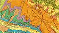
Telluride geologic map and location of historic mines
-
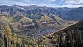
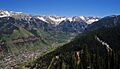
Fall colors in Telluride. View from the ski area, 2010
-
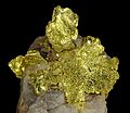
Historic gold specimen from Telluride
-
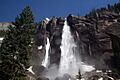
Bridal Veil Falls in Telluride
-
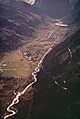
Aerial view of newly cut Boomerang Road (May 1972).
-
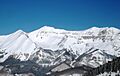
A view in Telluride from the ski slopes by Mountain Village.
-
Telluride from a gondola ascending to Mountain Village.
-
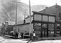
Brunswick Saloon, Telluride, circa 1900
See also
 In Spanish: Telluride para niños
