
Trent–Severn Waterway facts for kids
Quick facts for kids Trent–Severn Waterway |
|
|---|---|

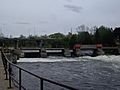
Gateway to the Trent-Severn Waterway
|
|
| Location | Ontario, Canada |
| Governing body | Parks Canada |
| Trent-Severn Waterway | |
|---|---|
| Specifications | |
| Length | 386 km (240 miles) |
| Maximum boat length | 84 ft 0 in (25.60 m) |
| Maximum boat beam | 23 ft 0 in (7.01 m) |
| Maximum boat draft | 2.4 m (8') Locks 1 – 19; 1.8 m (6') Locks 20 – 45 |
| Locks | 44 |
| Status | Open |
| History | |
| Construction began | 1833 |
| Geography | |
| Start point | Bay of Quinte |
| End point | Georgian Bay |
The Trent–Severn Waterway is a 386-kilometre-long (240 miles) canal route in Ontario, Canada. It connects Lake Ontario at Trenton to Georgian Bay, which is part of Lake Huron, at Port Severn. This amazing route uses natural rivers and lakes like the Trent River, Otonabee River, Kawartha Lakes, Lake Simcoe, Lake Couchiching, and Severn River. People often call it one of the best navigation systems in the world.
The idea for the canal first came from military needs. However, the first lock was built in 1833 for business. This opened up many lakes and rivers for steamships. The government started building more locks, but then the Upper Canada Rebellion happened in 1837. This made them rethink the project. They decided the canal would have too many locks for fast military travel. So, they finished the locks already started but turned other planned sections into timber slides for floating logs.
This left the middle part of the canal without a way to reach the big lakes. Businesses then built toll roads, plank roads, and later railways to connect to the canal. In the 1880s, the government led by John A. Macdonald restarted construction. They added more locks and pushed the route further west. For many years, the canal project was used by politicians to get votes, with little actual building happening.
Serious work began again just before 1900. The canal reached Peterborough and Lake Simcoe in 1904. The final parts were delayed by World War I. The link to Trenton opened in 1918, and the link to Georgian Bay opened in early 1920. The first boat to travel the entire waterway did so in July 1920.
By the time it was finished, the canal was no longer needed for big commercial ships. Ships on the Great Lakes had become much larger than the canal could handle. Also, railways now carried most of the freight. But the rise of motor boats made the Trent–Severn popular for pleasure boating. Today, it is a major tourist attraction in Ontario. It goes through beautiful cottage country, like Muskoka and the Kawarthas. This makes it perfect for cruising, attracting thousands of visitors each year. It is also a big part of the Great Loop. Today, it is a National Historic Site of Canada and a linear park run by Parks Canada. It is open for boats from May to October. Its land and bridges are open all year.
Exploring the Waterway's Features
The Trent–Severn Waterway is 386 kilometres (240 mi) long. About 32 kilometres (20 mi) of this length are man-made channels. It has 44 locks. These include 37 regular locks and two sets of flight locks. There are also special hydraulic lift locks at Peterborough and Kirkfield. A unique marine railway at Big Chute carries boats over land between different water levels.
The system also has 39 swing bridges and 160 dams. These structures control water levels for flood control and navigation. They manage water for an area of about 18,600 square kilometres (7,182 sq mi) in central Ontario. This area is home to over a million Canadians.
The highest point on the waterway is at Balsam Lake, at 256.3 metres (841 ft). This is the highest point a boat can reach from sea level in the Great Lakes–Saint Lawrence River drainage basin.

A Look at the Waterway's Past

Samuel de Champlain was the first European to travel these inland waters in 1615. He went from Georgian Bay to the Bay of Quinte with the Hurons. This was the same route that later became the Trent–Severn Waterway.
Early Military Plans
People started talking about a water route from Lake Ontario to Lake Huron as early as 1785. This idea became more important when the War of the First Coalition began in 1793. If the United States had joined the war, they could have blocked access to the upper Great Lakes. This would have stopped British trade at Michilimackinac.
To solve this, John Graves Simcoe, the Lieutenant-Governor of Upper Canada, began building Yonge Street. This road would provide a land route to Georgian Bay via Lake Simcoe. Construction started in 1794. The road was not fully usable until 1816. During the War of 1812, the route was used to ship supplies. An old anchor in Holland Landing marks where supplies were abandoned when the war ended.
The war showed the need for inland waterways. This led to building canals like the Rideau Canal. It connected Montreal, Ottawa, and Lake Ontario. This helped avoid dangers on the Saint Lawrence River. People still wanted a similar route to the upper lakes. Several surveys were done between 1815 and 1827. But the cost of the Rideau Canal, which was over $4 million, made people hesitant to fund another big project.
Bethune's First Lock
James Gray Bethune was a businessman in Cobourg. He owned a steamship company on Lake Ontario. He thought the inland sections north of Peterborough had good business potential. In 1832, Bethune launched the Pemedash on Rice Lake. It provided daily service between Peterborough and Cobourg. A second steamer, the Sturgeon, was launched in 1833. Both boats were popular for carrying goods.
In 1833, Bethune's group started building a lock at Bobcaygeon. The contract was for $8,000. Workers blasted the lock out of limestone. However, Bethune faced financial problems. The lock was not finished properly and leaked. It remained unusable for four years.
Baird's Important Surveys

Local politicians argued about where the canal should end. To settle this, a survey was ordered in 1833. Nicol Hugh Baird, an experienced engineer, was hired. Baird had worked on the Rideau Canal. His report in November 1833 estimated the cost to make the Trent River navigable to Rice Lake at over $1.1 million. It would need 34 locks and 17 dams.
In 1835, Baird surveyed the western section. He proposed another 32 locks and 13 dams, costing over $1.3 million. The total cost for the whole system would be over $2.4 million. Baird also suggested a cheaper plan using special barges that could be moved on short railway sections.
However, supporters of the Welland Canal opposed the Trent project. The Welland Canal connected Lake Ontario to Lake Erie. It was losing money and did not want another competitor. This opposition stopped further development for many years.
In 1836, the government proposed building four locks for $80,000. These included a new lock at Bobcaygeon and locks at Lindsay, Scott's Mills, and Hastings. These locks would open up a large area of waterway for continuous navigation. This was approved in November 1836.
A Pause in Construction
In 1837, the Upper Canada Rebellion happened. This led to big changes in the government. The new government's Board of Works looked at the canal project. They decided that a route with so many locks would be too slow for military use. They agreed to finish the four locks already started. This was mainly to provide jobs for new immigrants. They allowed other planned lock locations to be turned into timber slides for floating logs.
Connecting with Roads and Railways

With the four locks finished, the Back Lakes were open for navigation. New settlers brought more products to the area. By the 1850s, Peterborough had many mills. Logging companies and farmers used the lakes to ship their goods. But they needed a way to get these products to market. This led to a "railway rush" to connect to the waterway.
The Cobourg and Peterborough Railway opened in 1854. It crossed Rice Lake and connected directly to Peterborough. This railway was very successful. Later, the Midland Railway of Canada also reached Peterborough in 1858. Other railways connected to different points on the waterway, providing faster service to Toronto.
The Push to Finish the Canal
Work on the canal stopped until Confederation in 1867. After this, the new province of Ontario took control of construction. They could only afford small projects. They rebuilt the lock at Lindsay and built new ones at Young's Point and Rosedale. This made the navigable area larger, but it still had no outlet to the major lakes.
In 1879, a group of politicians formed the Trent Valley Canal Association. They pushed for more work on the canal. They held meetings and collected petitions. This put constant pressure on the government. The government of John A. Macdonald agreed to fund new locks at Burleigh Falls, Lovesick Lake, Buckhorn, and Fenelon Falls. This greatly expanded the navigable route.
One difficult section was at Burleigh Falls. Workers used steam-powered drills and shovels. In 1885, a tragic accident happened. A load of dynamite exploded, leaving a large crater. Construction faced many arguments and delays. Finally, the work was completed in 1887. The first boat passed through this section on October 26.
More Delays and Reports
After the 1887 election, work on the canal slowed again. Many people felt that Macdonald was only interested in the canal to get votes. A new survey was ordered to estimate the cost of completing the entire route. The estimate came back at almost $10 million, much higher than earlier estimates.
Because of the huge differences in cost estimates, Macdonald formed the Trent Valley Canal Commission in 1887. This was seen as a way to delay the project. The commission took a long time to produce its final report. In 1890, they agreed the routes were possible and desirable. They also suggested using hydraulic boat lifts instead of many locks in complex areas.
The Decision to Complete the Canal
By the 1891 election, Macdonald used the canal promise to win votes. He promised that parliament would fund the canal's completion. This helped him win many seats in the area. Macdonald died shortly after the election.
After Macdonald's death, the Conservative government struggled. Despite promises, little work was done. In 1895, contracts were signed for sections between Balsam Lake and Kirkfield, and Lakefield to Peterborough. People were annoyed, saying the canal was just a "vote-catching machine."
In the 1896 election, Wilfrid Laurier and the Liberals won. They immediately cancelled the work. But the same political pressure that affected the Conservatives soon influenced the Liberals. The Trent Association argued that the canal could ship grain from western Canada.
Laurier initially supported a new canal along the St. Lawrence. But the Association brought over 270 delegates to Ottawa to argue for the Trent. Laurier finally announced that his government would complete the Trent Valley route. This was met with great applause.
Challenges from Toronto
By this time, large commercial canals were becoming less important. Freight was moving to railways. Businesses in Toronto, especially railway companies, worried about competition from the canal. When the first $600,000 contract was announced in 1898, Edmund Osler, a director of the Canadian Pacific Railway (CPR), opposed it. He said the government had "money to burn."
Laurier's government delayed further work. However, the Liberals changed their policies to support public works projects, especially in areas that could be swayed politically. This included the Trent system, which became a key part of their strategy. With their election win, the Liberals began the final completion of the Trent system.
The Newmarket Canal Project

While the main canal was being built, a side project began. William Mulock, a key Liberal politician from Newmarket, wanted to extend the Trent south to his town. This extension was called the Newmarket Canal.
Critics immediately said the project had no economic value. But Mulock wanted to bring federal money to his area. The cost of the short link grew to almost $1 million. Even after Mulock left his seat in 1905, the party continued to support the project. It faced constant attacks in parliament and scorn in the press. Calculations showed there was not enough water to keep it running in the summer.
The 1911 election ended this project, which was called "Mulock's madness." The new government cancelled it. The unfinished parts, about 85% complete, were abandoned. Locals still call it the "ghost canal."
The Waterway Today
Travel beyond Balsam Lake was blocked until the Kirkfield Lift Lock opened in 1907. The lock system helped central Ontario grow. It allowed goods to move easily to and from major trading centers on Lake Ontario. Land travel in this rugged area was very difficult.
When the canal was finally finished, it did not have a big impact on the economy. Its design was too small for the larger boats used for commerce at the time. Railways had also developed their networks, changing how people settled and transported goods.
The waterway became outdated for commercial use when the modern Welland Canal was completed in 1932. The Welland Canal could handle much larger ships.
The Trent-Severn system is still used today. Parks Canada maintains and operates it. Now, it is used for tourism and by recreational boaters. There are cruise lines and houseboat rentals. In 2013, a bill was introduced to help fund repairs for the century-old waterway.
You can find technical details like speed limits and bridge clearances on Parks Canada's website.
Images for kids
-
Trent–Severn Waterway entering Peterborough at Scotts Mills
-
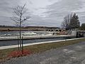
Lock 25 - Sawer Creek


.jpg)
