Belmont, New Hampshire facts for kids
Quick facts for kids
Belmont, New Hampshire
|
|
|---|---|
|
Town
|
|

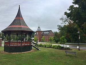
Village Bandstand and Belmont Mill in 2019
|
|

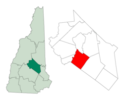
Location in Belknap County, New Hampshire
|
|
| Country | United States |
| State | New Hampshire |
| County | Belknap |
| Incorporated | 1859 |
| Villages | |
| Area | |
| • Total | 31.9 sq mi (82.6 km2) |
| • Land | 30.0 sq mi (77.6 km2) |
| • Water | 1.9 sq mi (5.0 km2) 6.08% |
| Elevation | 528 ft (161 m) |
| Population
(2020)
|
|
| • Total | 7,314 |
| • Density | 244/sq mi (94.3/km2) |
| Time zone | UTC-5 (Eastern) |
| • Summer (DST) | UTC-4 (Eastern) |
| ZIP code |
03220
|
| Area code(s) | 603 |
| FIPS code | 33-04740 |
| GNIS feature ID | 0873542 |
Belmont is a town located in Belknap County, New Hampshire, in the United States. In 2020, about 7,314 people lived there.
The main part of Belmont, where most people live, is called the Belmont census-designated place (CDP). This area is near where New Hampshire Route 106 and New Hampshire Route 140 roads meet.
Contents
Belmont's Past: A Look at Its History
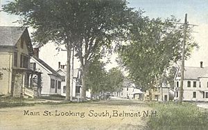
Belmont was first known as "Upper Gilmanton." It was set up in 1727 as a part of Gilmanton. The town grew because of the water power from the Tioga River. This power helped run mills, making Belmont a "mill town."
In 1833, the Gilmanton Village Manufacturing Co. was built. It made cotton and woolen fabrics. Over the years, the mill changed owners and what it produced. By 1921, it was the Belmont Hosiery Co., making stockings from silk, lisle, and wool. The mill closed in 1955. Today, the old mill building has been updated and is now a community center for the town.
Belmont officially became its own town on June 28, 1859. It was separated from Gilmanton by a decision from the state legislature. At first, it was still called Upper Gilmanton. In 1869, the town changed its name to Belmont. This was done to honor August Belmont, a very rich banker. People hoped he would help the new town with money, but he never did.
In 1874, the Boston, Concord and Montreal Railroad built tracks through the northwestern part of Belmont. This brought train service to the area.
Historic Buildings and Landmarks
The old Belmont Mill building was renovated between 1996 and 1998. This project received awards for its design and for saving a historic building. The story of the Belmont Mill is even featured on a New Hampshire historical marker (number 235) nearby. In 2014, the mill was added to the New Hampshire Register of Historic Places.
Other important historic buildings in Belmont include the 1792 Province Road Meeting House. The Belmont Public Library was added to the National Register of Historic Places in 1985. The town's Bandstand also received an award in 2015 for its excellent restoration.
Belmont's Location and Natural Features
Belmont covers a total area of about 82.6 square kilometers (31.9 square miles). About 77.6 square kilometers (29.9 square miles) of this is land, and 5.0 square kilometers (1.9 square miles) is water. Water makes up about 6.08% of the town's total area.
The highest point in Belmont is Cotton Hill. This hill is about 1,360 feet (415 meters) high and is located near the town's northern edge. The Tioga River flows through Belmont. All the water in Belmont eventually flows into the Merrimack River watershed.
Major Roads in Belmont
Several important roads pass through Belmont:
- New Hampshire Route 106 goes through the center of town. It connects Laconia to the north with Loudon and Concord to the south.
- New Hampshire Route 140 crosses NH 106 in the town center. It leads to Gilmanton and Alton to the east, and Tilton to the west.
- U.S. Route 3 and New Hampshire Route 11 run together through the northwest part of town. They follow the shore of Lake Winnisquam. These roads go north to Laconia and southwest to Tilton and Franklin.
- New Hampshire Route 107 crosses the northeastern corner of Belmont. It connects Gilmanton to the south with Laconia to the north.
Neighboring Towns
Belmont shares its borders with these towns:
- Laconia (to the north)
- Gilford (to the northeast)
- Gilmanton (to the east)
- Northfield (to the south)
- Tilton (to the west)
- Sanbornton (to the northwest)
People of Belmont: Demographics
| Historical population | |||
|---|---|---|---|
| Census | Pop. | %± | |
| 1860 | 1,189 | — | |
| 1870 | 1,165 | −2.0% | |
| 1880 | 1,226 | 5.2% | |
| 1890 | 1,142 | −6.9% | |
| 1900 | 1,294 | 13.3% | |
| 1910 | 1,390 | 7.4% | |
| 1920 | 1,194 | −14.1% | |
| 1930 | 1,299 | 8.8% | |
| 1940 | 1,374 | 5.8% | |
| 1950 | 1,611 | 17.2% | |
| 1960 | 1,953 | 21.2% | |
| 1970 | 2,493 | 27.6% | |
| 1980 | 4,026 | 61.5% | |
| 1990 | 5,796 | 44.0% | |
| 2000 | 6,716 | 15.9% | |
| 2010 | 7,356 | 9.5% | |
| 2020 | 7,314 | −0.6% | |
| U.S. Decennial Census | |||
In 2010, there were 7,356 people living in Belmont. They lived in 2,941 households, and 2,069 of these were families. About 31.6% of households had children under 18 living with them. Most households (53.0%) were married couples.
The population of Belmont is mostly White (97.0%). A small percentage of the population is from other racial backgrounds. About 1.3% of the people were of Hispanic or Latino origin.
The average age of people in Belmont in 2010 was 42.1 years old. About 21.8% of the population was under 18 years old. About 13.5% of the population was 65 years or older.
From 2011 to 2015, the average yearly income for a household in Belmont was about $65,150. For families, the average income was about $72,539. About 7.9% of the people in Belmont lived below the poverty line.
Famous People from Belmont
- William Badger (1779–1852), who served as the 15th governor of New Hampshire.
See also
 In Spanish: Belmont (Nuevo Hampshire) para niños
 | Valerie Thomas |
 | Frederick McKinley Jones |
 | George Edward Alcorn Jr. |
 | Thomas Mensah |


