Warrenton, Virginia facts for kids
Quick facts for kids
Warrenton, Virginia
|
||
|---|---|---|
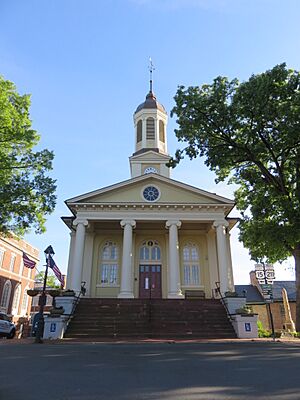
Courthouse Square
|
||
|
||
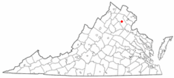
Location in Virginia
|
||
| Country | United States | |
| State | Virginia | |
| County | Fauquier | |
| Founded | 1810 | |
| Named for | Joseph Warren | |
| Government | ||
| • Type | Council-Manager | |
| Area | ||
| • Total | 4.38 sq mi (11.34 km2) | |
| • Land | 4.37 sq mi (11.33 km2) | |
| • Water | 0.01 sq mi (0.01 km2) | |
| Elevation | 643 ft (196 m) | |
| Population
(2020)
|
||
| • Total | 10,057 | |
| • Estimate
(2021)
|
10,109 | |
| • Density | 2,296.1/sq mi (885.01/km2) | |
| Time zone | UTC-5 (Eastern (EST)) | |
| • Summer (DST) | UTC-4 (EDT) | |
| ZIP codes |
20186-20188
|
|
| Area code(s) | 540, 703, 571 | |
| FIPS code | 51-83136 | |
| GNIS feature ID | 1500278 | |
Warrenton is a town in Fauquier County, Virginia, United States. It is the main town for the county. In 2020, about 10,057 people lived here. This was more than the 9,611 people in 2010.
Warrenton is located where several major roads meet. These include U.S. Route 15, U.S. Route 17, U.S. Route 29, and U.S. Route 211. The town is in the Piedmont area of Virginia. This is just east of the Blue Ridge Mountains. Warrenton is known for its nearby Virginia wine and horse farms. It is a popular place to visit not far from Washington, D.C..
Warrenton shares some services with the county, like schools.
Contents
History of Warrenton
The town of Warrenton started as a small trading spot. It was at a place where two main roads crossed. There was a trading post called the Red Store. In the 1790s, a courthouse was built there. People then called the area "Fauquier Courthouse."
The town of Warrenton officially became a town on January 5, 1810. It was named after General Joseph Warren. He was a hero from the Revolutionary War. A person named Richard Henry Lee gave the land for the county's main town.
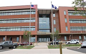
During the Civil War, a Confederate officer named John S. Mosby led raids in the town. After the war, he lived and worked as a lawyer in Warrenton. The Warren Green Hotel is a famous building in town. Many important people stayed there, like the Marquis de Lafayette and Presidents James Monroe and Andrew Jackson. In 1862, Union General George B. McClellan said goodbye to his officers from the hotel steps. Today, some county offices are in this building.
In 1909, a big fire destroyed almost half of the town's buildings. People used dynamite to create a gap. This stopped the fire from spreading further.
In 1951, the government built the Warrenton Training Center near the town. This center is a secret communications place for the Central Intelligence Agency. It also has an underground bunker. This bunker helps keep important communications working. It would be used if there was a major attack on Washington, D.C.
In the early 1960s, a new road was built around the town. This road brought new restaurants, gas stations, and shopping centers. But it also caused some businesses to move away from the old town center.
The Warrenton Historic District was added to the National Register of Historic Places in 1983. This means it is a special place with important old buildings. Other historic places near Warrenton include Brentmoor and Hopefield.
Warrenton's Location and Land
Warrenton is in the middle of Fauquier County. It is located at coordinates 38°43′06″N 77°47′50″W. U.S. Route 29 goes northeast 12 miles to Gainesville. It goes 47 miles to Washington, D.C.. To the southwest, it goes 25 miles to Culpeper.
U.S. Route 15 also follows US 29 in and out of town. But it goes north-northeast 34 miles to Leesburg. U.S. Route 17 goes northwest 42 miles to Winchester. It goes southeast 44 miles to Fredericksburg. U.S. Route 211 goes west 34 miles to Skyline Drive in Shenandoah National Park.
Warrenton covers about 4.38 square miles (11.34 square kilometers) of land. Only a very small part is water. The eastern, southern, and northern parts of the town drain into Cedar Run. This stream flows into the Occoquan River. The Occoquan River is part of the larger Potomac River system. The western part of town drains into Great Run. This stream flows into the Rappahannock River.
Education in Warrenton
Schools for Kids and Teens
Fauquier County Public Schools serves the town of Warrenton.
- Elementary Schools: For Kindergarten to fifth grade, there are James G. Brumfield Elementary, Carson M. Bradley Elementary, and Peter B. Smith Elementary.
- Middle Schools: Taylor Middle School serves grades six through eight.
- High Schools: Fauquier High School teaches students from ninth to twelfth grade.
There are also three private schools in Warrenton: Highland School, St. John The Evangelist's Catholic School, and St. James' Episcopal School.
Colleges and Universities
The Fauquier campus of Laurel Ridge Community College is located just south of Warrenton. This college offers classes for older students. In 2022, a new building for science and health studies opened there.
Public Libraries
The Fauquier Public Library has a branch in the Warrenton Historic District. This library is run by the county government. Each public school also has its own library. You can also find small public bookshelves around town. These are like mini-libraries where people can share books.
Arts and Culture
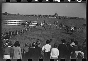
Horse races, especially steeplechases, are a big part of the culture in Fauquier County and Warrenton. The first Virginia Gold Cup race was held near Warrenton in 1922. This event became very famous. In 1984, the race moved to The Plains, a nearby town. The Virginia Gold Cup and International Gold Cup Race still attract many thousands of people each year.
On the first Friday of every month, from May to October, Warrenton hosts a "First Friday" street fair. This event takes place in the Warrenton Historic District. Each month has a different theme. Local sellers and activities change with the theme.
Warrenton also has four public parks and a recreation center. The town has several public art pieces. In 2001, Stewart Burgess White painted three murals on a building. These murals show scenes from the Civil War. Other artists have also created murals in the town.
Transportation
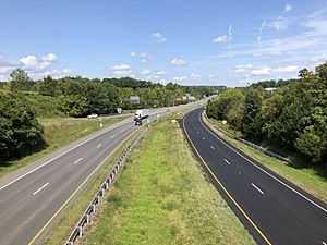
Warrenton is served by four major U.S. Routes: U.S. Route 15, U.S. Route 17, U.S. Route 29, and U.S. Route 211. These roads now go around the town center on bypasses.
- US 15 goes north to Leesburg and south to Orange.
- US 17 goes northwest to Winchester and southeast to Fredericksburg.
- US 29 goes northeast to Washington, D.C. and southwest to Charlottesville.
- US 211 starts north of downtown and goes west through Luray.
The old roads that went through downtown are now called "Business" routes. For example, U.S Route 15 Business serves the downtown area.
There are also bus services in Warrenton. Virginia Regional Transit runs a local bus. Academy Bus offers a bus service for people who travel to Washington, D.C. for work. There is also a weekday bus service called the Piedmont Express. It goes from Danville to Washington, D.C., with a stop in Warrenton.
Notable People
- James DeRuyter Blackwell, poet and writer
- Steve Brodie, Major League Baseball player
- Edward Brooke, U.S. senator
- Anthony Cave Brown, journalist and historian
- Jesse Brown, former U.S. Secretary of Veterans Affairs
- Matt Carson, entrepreneur and author
- Samuel Chilton, 19th-century politician and lawyer
- Walter Chrysler, founder of the Chrysler Corporation car company
- Walter P. Chrysler Jr., art collector
- Julia Ringwood Coston, 19th-century publisher
- Mike Duvall, Major League Baseball player
- George B. Fitch, former mayor of Warrenton
- Ella Fitzgerald, drag queen
- Benita Fitzgerald-Brown, Olympic athlete
- Grenville Gaines, mayor of Warrenton
- Craig Gilmore, winner of a sports challenge
- John S. Horner, acting governor of Michigan Territory
- Eppa Hunton, U.S. congressman and senator
- John C. Mackie, U.S. congressman
- Malcolm MacPherson, Newsweek writer and author
- Frances Harrison Marr, poet
- Charles Marshall, Confederate States Army colonel
- James K. Marshall, Confederate States Army colonel
- John Augustine Marshall, U.S. federal judge
- Thomas Love Moore, U.S. congressman and lawyer
- William Moore, blues musician
- John S. Mosby, Confederate cavalry commander
- William H. F. Payne, Confederate States Army general
- Dorothy B. Porter, bibliographer and curator
- Scott Shipp, superintendent of the Virginia Military Institute
- William "Extra Billy" Smith, congressman and governor of Virginia
- Gwyn R. Tompkins, horse racing trainer
- Septimus Tustin, clergyman
- Erica Wallach, political activist and teacher
- Sarah White, singer-songwriter
- Charles S. Whitehouse, U.S. Ambassador
- Bonnie Zacherle, illustrator and designer
Climate
Warrenton has hot, humid summers. Its winters are usually mild to cool. This type of weather is called a humid subtropical climate.
Population Information
| Historical population | |||
|---|---|---|---|
| Census | Pop. | %± | |
| 1860 | 604 | — | |
| 1870 | 1,256 | 107.9% | |
| 1880 | 1,464 | 16.6% | |
| 1890 | 1,346 | −8.1% | |
| 1900 | 1,627 | 20.9% | |
| 1910 | 1,427 | −12.3% | |
| 1920 | 1,545 | 8.3% | |
| 1930 | 1,450 | −6.1% | |
| 1940 | 1,651 | 13.9% | |
| 1950 | 1,797 | 8.8% | |
| 1960 | 3,522 | 96.0% | |
| 1970 | 4,027 | 14.3% | |
| 1980 | 3,907 | −3.0% | |
| 1990 | 4,830 | 23.6% | |
| 2000 | 6,670 | 38.1% | |
| 2010 | 9,611 | 44.1% | |
| 2020 | 10,057 | 4.6% | |
| 2023 (est.) | 10,210 | 6.2% | |
| U.S. Decennial Census | |||
2020 Census Details
In 2020, the town of Warrenton had 10,057 people. There were 4,016 households, which are groups of people living together. About 2,159 of these were family households. The town had about 2,296 people per square mile.
Most of the people in Warrenton were White (77.0%). About 10.0% were African American, and 1.7% were Asian. People from two or more races made up 9.9%. About 8.9% of the population was Hispanic or Latino.
More than half of the residents (56.4%) were female. About 22.7% of the people were under 18 years old. And 16.7% were 65 years or older. The population pyramid below shows the number of males and females in different age groups.
| Population pyramid 2021 | ||||
| % | Males | Age | Females | % |
| 0.84 | 85+ | 1.70 | ||
| 0.03 | 80–84 | 2.63 | ||
| 1.51 | 75–79 | 1.69 | ||
| 1.76 | 70–74 | 2.24 | ||
| 1.85 | 65–69 | 2.36 | ||
| 4.51 | 60–64 | 4.87 | ||
| 4.50 | 55–59 | 3.50 | ||
| 2.01 | 50–54 | 4.60 | ||
| 3.28 | 45–49 | 3.52 | ||
| 0.93 | 40–44 | 2.11 | ||
| 3.17 | 35–39 | 3.67 | ||
| 2.01 | 30–34 | 2.34 | ||
| 2.58 | 25–29 | 2.77 | ||
| 4.49 | 20–24 | 2.84 | ||
| 2.92 | 15–19 | 3.54 | ||
| 2.65 | 10–14 | 3.8 | ||
| 1.98 | 5–9 | 2.71 | ||
| 2.61 | 0–4 | 5.36 | ||
Most households (92.0%) had access to a computer. And 87.1% had fast internet. About 11.1% of households spoke a language other than English at home. Most households (63.1%) owned their homes. The average income for a household was $78,275. About 6.2% of the town's people lived in poverty.
When it comes to getting to work, most people (74.7%) drive alone. About 12.4% share a ride with others. Only a small number walk (3.3%). The average time people spent traveling to work was about 33 minutes.
See also
 In Spanish: Warrenton (Virginia) para niños
 | Valerie Thomas |
 | Frederick McKinley Jones |
 | George Edward Alcorn Jr. |
 | Thomas Mensah |


