
1932 San Ciprián hurricane facts for kids
| Category 4 major hurricane (SSHWS/NWS) | |

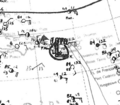
Surface weather analysis of the storm while over Puerto Rico on September 27
|
|
| Formed | September 25, 1932 |
|---|---|
| Dissipated | October 2, 1932 |
| Highest winds | 1-minute sustained: 145 mph (230 km/h) |
| Lowest pressure | 943 mbar (hPa); 27.85 inHg |
| Fatalities | 272 |
| Damage | > $35.8 million (1932 USD) |
| Areas affected | Virgin Islands, Puerto Rico, Dominican Republic |
| Part of the 1932 Atlantic hurricane season | |
The 1932 San Ciprián hurricane was a very powerful tropical cyclone that hit Puerto Rico. It was one of the strongest storms ever recorded there. The hurricane moved across the island from east to west in late September 1932. It caused a lot of damage and sadly, 272 people lost their lives.
Winds in San Juan, Puerto Rico, were super strong, reaching at least 120 mph (195 km/h). This caused huge destruction. The storm started as a tropical storm on September 25, 1932, east of the Windward Islands. It quickly grew stronger as it moved across the Virgin Islands. On September 27, it hit Ceiba, Puerto Rico, as a Category 4 hurricane. This is a very high level on the Saffir–Simpson Hurricane Scale, which measures hurricane strength.
After leaving Puerto Rico, the hurricane became weaker. It passed by the southern coast of Hispaniola and then near Jamaica on September 29. Finally, it reached British Honduras (now Belize) on October 1 as a tropical storm and disappeared over southeastern Mexico the next day.
The hurricane brought strong winds to parts of the Virgin Islands. In Saint Thomas, trees and power lines were blown down, and homes were damaged. Some ships also sank in the harbors of Saint Thomas and Tortola. The damage in Saint Thomas was estimated to be over $200,000, and 15 people died there. Most of the damage from the San Ciprián hurricane happened in Puerto Rico, especially in the northern areas. The strong winds destroyed many buildings. Over 40,000 homes were ruined, leaving 25,000 families without a place to live. This caused about $15.6 million in property damage. Crops like citrus fruits and coffee also suffered heavy losses. In Puerto Rico, 257 people died, and 4,820 were injured. The total economic damage was about 20 percent of Puerto Rico's total income at the time.
Contents
How the Hurricane Formed and Moved

This hurricane took an unusual path because of high air pressure in the Atlantic Ocean. It mostly moved west and southwest. We don't know exactly how the storm started because there weren't many weather reports back then.
In 2012, scientists studied the storm's history. They found that it became a tropical storm with winds of 60 mph (95 km/h) by September 25, 1932. At this time, it was about 340 mi (550 km) east of Antigua. The storm quickly gained strength as it moved west, becoming a hurricane by September 25.
Early on September 26, the hurricane passed near Antigua and Saint Barthelemy. Later, it moved between Saint Thomas and Saint Croix. Around 13:00 UTC on September 26, the storm's center passed near Saba with winds of 140 mph (220 km/h). This showed it was a small and fast-growing hurricane.
Hurricane Hits Puerto Rico
Around 04:00 UTC on September 27, the strong hurricane hit Puerto Rico near Ensenada Honda in Ceiba. When it made landfall, its winds were about 145 mph (230 km/h). This made it a Category 4 hurricane on the Saffir–Simpson Hurricane Scale. The area with hurricane-force winds was small, probably less than 23 mi (37 km) wide.
The storm's center moved across Puerto Rico for seven hours, from east to west. It then went into the Caribbean Sea near Aguadilla. Moving over land made the storm weaker, with winds dropping to 105 mph (165 km/h). It kept this strength until it hit the southern parts of the Dominican Republic and Haiti on September 28. This second landfall weakened the storm a lot, reducing its winds to 45 mph (75 km/h).
The storm then moved slightly southwest, passing near Jamaica on September 29. It might have even become a tropical depression for a short time. The storm got a little stronger again before making its final landfall south of Belize City in British Honduras around 18:00 UTC on October 1. Its winds were 45 mph (75 km/h). It then moved west-southwest into southeastern Mexico and finally disappeared on October 2.
Impacts of the Hurricane

Virgin Islands Damage
The hurricane was small, which was clear from the wind reports in Saint Thomas and Saint Croix. Even though the storm's center passed between these islands, neither experienced full hurricane-force winds. Speeds only reached about 60 mph (95 km/h). The United States Weather Bureau said the damage on Saint Barthélemy, Saint John, Saint Thomas, and Tortola was "moderate."
Legislative elections in the Virgin Islands had to be delayed because of the bad weather. Two boats full of passengers were lost in Tortola. Winds of 60–90 mph (95–145 km/h) swept across Saint Barthelemy. Radio antennas were blown down in Saba. On Saint Thomas, warning guns were fired 90 minutes before the storm arrived, giving people time to find shelter. Many houses were damaged, and wires and trees were blown down. Small ships sank in the Saint Thomas harbor. Sadly, 15 people died, and property losses were over $200,000. Many huts and crops were destroyed, leaving hundreds of people without homes or food. The Red Cross and the Saint Thomas government gave $6,000 to help with recovery.
Puerto Rico Damage
The Weather Bureau office in San Juan first learned about the storm on September 26. They issued their first warning that evening. The warnings were shared across Puerto Rico by the territorial government, the U.S. Navy, and local radio station WKAQ. The Weather Bureau praised these groups, saying their efforts greatly reduced the loss of life and property. San Juan had 18 hours of warning before the hurricane hit.
Before the hurricane season, the Governor of Puerto Rico, James R. Beverly, had told mayors to set up emergency committees. These committees were supposed to raise hurricane flag signals at churches and city halls when a warning was issued. Mayors and police were told to protect people and property. The governor also held a meeting to plan for emergencies, including fixing communication lines and helping people evacuate to strong buildings. The American Red Cross in the U.S. also got ready to send help to Puerto Rico.
Forty-nine municipalities of Puerto Rico were affected by the storm. The northern half of the territory saw the worst damage. The hurricane killed 257 people, mostly from buildings collapsing. Wind-blown debris and drownings also caused some deaths. Over 4,820 people were injured. Even though people tried to find shelter, only very strong concrete buildings survived in the hardest-hit areas. Homes with metal roofs that were not properly attached were destroyed. In total, 45,554 houses were completely destroyed, and another 47,876 were partly damaged. The damage was as bad as an F3 tornado. The governor said the damage was even worse than the 1928 San Felipe hurricane in the affected areas. Nearly 500,000 animals, including cows, goats, horses, pigs, and chickens, also died.
Ships in the Port of San Juan were heavily damaged. The steamships Jean and Acacia were stuck on the ground but were later refloated. Several pier buildings were badly hit. The Gaviota schooner was wrecked in the harbor. Telephone and telegraph lines between San Juan and eastern Puerto Rico were cut on the night of September 26. The worst of the storm hit San Juan shortly after midnight on September 27 and lasted for about three hours. Hurricane-force winds lasted for six hours. Winds of at least 120 mph (195 km/h) hit San Juan. In San Juan, Hato Rey, and Río Piedras, hundreds of homes were blown away, and trees were uprooted. Reports said that all homes collapsed in Fajardo and Toa Alta. All communication and electric poles and wires were knocked down. WKAQ's radio towers were toppled and twisted by the wind.
Rainfall in Puerto Rico was lower than in other strong hurricanes. The most rain, 16.70 in (424 mm), was measured in Maricao. The total damage to property and crops was $35.6 million. Property damage was $15.6 million, and crop damage was $20 million. The main areas that grew citrus fruits were hit the hardest, leading to huge losses for these crops. Coffee plantations were also damaged by fallen banana trees, which had been planted to shade new coffee crops. This delayed harvests for several years. Other crops were completely lost but could be replanted within a growing season. Forests in the Sierra de Luquillo lost their leaves, and many trees died from the heavy rains and strong winds. East of Puerto Rico, Culebra and Vieques also suffered heavy damage.
Recovery Efforts
Workers from the Puerto Rican Department of the Interior, with help from prisoners and volunteers, quickly cleared roads after the storm. National Guard and Red Cross workers were sent to help. Medical and food supplies were given out in the larger affected towns within 24 hours. A Hurricane Relief and Rehabilitation Commission was formed on September 27 to work with the Red Cross. This group helped control prices and raised money for immediate needs. They collected nearly $75,000. This money added to an emergency fund set up by the Puerto Rican government, which provided $165,000 in relief. The Red Cross provided food and shelter. The American military in Puerto Rico also gave supplies. Two flights were made on September 27 and 28 to see how bad the damage was across northern Puerto Rico. Teachers helped count property damage, and the Commissioner of Agriculture and Commerce counted crop damage. The Red Cross reported that 76,925 families were in "actual distress" because of the hurricane. The destruction of homes left 25,000 families homeless. The total economic losses from the storm were about 20 percent of Puerto Rico's total income.
Impacts Elsewhere
In the Dominican Republic, people were worried about another disaster because they were still recovering from another hurricane two years earlier. Residents closed businesses and evacuated, with some seeking shelter in churches. The 1932 storm brought 90 mph (145 km/h) winds to San Pedro de Macorís and 50 mph (80 km/h) winds to Santo Domingo. Farms in Santo Domingo had "considerable damage."
Hurricane warning flags were raised in Jamaica on September 29. Store owners secured their shops, and ships in the harbor moved to safer places. Luckily, the storm passed south of Jamaica and caused little harm. Warning flags were also raised in British Honduras on October 1, leading to business closures and storm preparations. However, the storm moved over British Honduras with little force, causing no damage there.
Images for kids
-
Surface weather analysis of the storm while over Puerto Rico on September 27
-
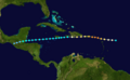
A map of the Caribbean Sea showing the path of the hurricane from beginning east of the Leeward Islands and terminating over Central America
-
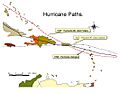
The tracks of three Puerto Rican hurricanes, including the 1932 storm
