2019 Ridgecrest earthquakes facts for kids
| UTC time | |
|---|---|
| A: 2019-07-04 17:33:49 | |
| B: 2019-07-05 11:07:53 | |
| C: 2019-07-06 03:19:52 | |
| D: 2020-06-03 01:32:11 | |
| ISC event | |
| A: 616042637 | |
| B: 616043696 | |
| C: 616046044 | |
| USGS-ANSS | |
| A: ComCat | |
| B: ComCat | |
| C: ComCat | |
| D: ComCat | |
| Local date | |
| A: July 4, 2019 | |
| B: July 5, 2019 | |
| C: July 5, 2019 | |
| D: June 3, 2020 | |
| Local time | |
| A: 10:33 a.m. PDT | |
| B: 4:08 a.m. PDT | |
| C: 8:19 p.m. PDT | |
| D: 6:32 p.m. PDT | |
| Magnitude | |
| A: Mw 6.4 | |
| B: Mw 5.4 | |
| C: Mw 7.1 | |
| D: Mw 5.5 | |
| Depth | |
| A: 10.7 km (6.6 mi) | |
| B: 7.0 km (4.3 mi) | |
| C: 8.0 km (5.0 mi) | |
| D: 6.8 km (4.2 mi) | |
| Epicenter | 35°45′58″N 117°36′18″W / 35.766°N 117.605°W |
| Type | Strike-slip |
| Areas affected | California, Nevada, Arizona |
| Total damage | $5.3 billion |
| Max. intensity | IX (Violent) |
| Peak acceleration | 0.48 g |
| Foreshocks | 2 (≥2.5 Mw) (including before main foreshock) |
| Aftershocks | 4,000 ~1,200 (≥2.5 Mw) (including after main foreshock) |
| Casualties | 1 death, 25 injured (20 on July 4, 5 on July 5) |
The 2019 Ridgecrest earthquakes were a series of strong earthquakes that hit California in July 2019. They happened near the town of Ridgecrest, California, which is in Kern County. The quakes were also close to Searles Valley, California.
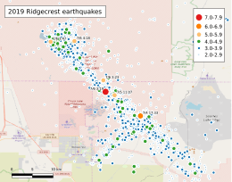
There were three main quakes: a 6.4 magnitude, a 5.4 magnitude, and a 7.1 magnitude. Many smaller quakes, called aftershocks, followed. Most of these happened near the Naval Air Weapons Station China Lake. About 11 months later, a 5.5 magnitude aftershock, which was the strongest one, occurred east of Ridgecrest.
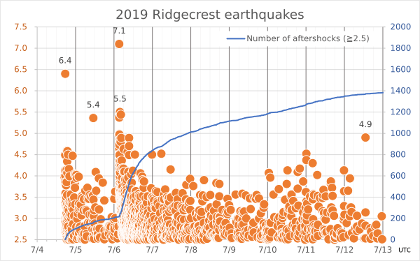
The first big quake (magnitude 6.4) happened on Thursday, July 4, at 10:33 a.m. PDT. It was about 18 kilometers (11.2 miles) northeast of Ridgecrest. This quake was later seen as a foreshock, meaning it came before the main, stronger quake. It was followed by over 1,400 smaller aftershocks.
The 5.4 and 7.1 magnitude quakes struck on Friday, July 5. The 7.1 magnitude quake, which happened at 8:19 p.m. PDT, is now considered the main earthquake. It was the most powerful earthquake in California in 20 years. Aftershocks from this quake spread out about 50 kilometers (30 miles) along a fault line called the Little Lake Fault Zone.
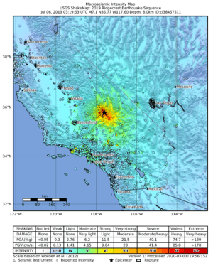
The first quake caused only minor damage, but some buildings in Ridgecrest caught fire. The main quake on July 5 caused power outages for at least 3,000 homes in Ridgecrest. People felt the shaking across much of Southern California, and even in parts of Arizona and Nevada. It was felt as far north as the San Francisco Bay Area and Sacramento, California, and as far south as Baja California, Mexico. About 20 million people felt the first quake, and around 30 million felt the main quake.
Contents
Understanding the Earthquakes
On July 4, 2019, at 10:33 a.m. PDT, a 6.4 magnitude earthquake happened about 12 kilometers (7.5 miles) southwest of Searles Valley. The closest town was Ridgecrest, California, which has about 28,000 people.
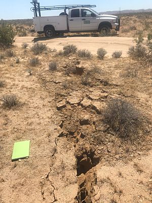
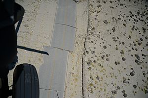
This earthquake happened along a strike-slip fault. This is a type of fault where two blocks of Earth's crust slide past each other horizontally. The area where it happened, called the Eastern California Shear Zone, often has many earthquakes. The ground shifted about 15–20 centimeters (6–8 inches) on either side of the fault. The quake was fairly shallow, about 10.7 kilometers (6.6 miles) deep, which made its shaking felt over a large area. People near the center felt shaking for about 30 seconds.
Then, on July 5, at 8:19 p.m. PDT, a much stronger 7.1 magnitude earthquake hit the Ridgecrest area. This quake was so big that it made the earlier 6.4 quake seem like just a foreshock. Both earthquakes happened because of shallow strike-slip movements. The shaking from these quakes spread along two faults that cross each other in the Little Lake Fault Zone.
Aftershocks: Quakes That Follow
After the first big quake, many smaller earthquakes, called aftershocks, followed. Most of these were between 2 and 4 magnitude. By the evening of July 5, more than 1,400 aftershocks had occurred. The strongest of these was a 5.4 magnitude quake on July 5 at 4:07 a.m. PDT. This aftershock was felt in many cities, including Los Angeles and Las Vegas, Nevada. Luckily, these aftershocks did not cause more damage.
After the 7.1 magnitude main earthquake, thousands more aftershocks happened. By July 7, there were over 3,000 aftershocks. Experts believed that about 34,000 more aftershocks would happen in the six months after the main quakes.
On June 3, 2020, a 5.5 magnitude aftershock was recorded south of Searles Valley. This was one of the strongest aftershocks after the 7.1 magnitude main quake.
| Date | Time (UTC) | Magnitude Mw | MMI | Depth | Location | Ref. |
|---|---|---|---|---|---|---|
| July 4 | 17:33:49 | 6.4 | VIII | 6.4 mi (10.3 km) | 7.5 mi (12 km) SW of Searles Valley | |
| July 4 | 18:39:44 | 4.6 | VI | 1.7 mi (2.8 km) | 4.3 mi (7 km) ESE of Ridgecrest | |
| July 4 | 18:56:06 | 4.6 | VI | 1.2 mi (1.9 km) | 9.3 mi (15 km) NE of Ridgecrest | |
| July 4 | 19:21:32 | 4.5 | VI | 3.2 mi (5.2 km) | 8.1 mi (13 km) SSW of Searles Valley | |
| July 5 | 11:07:53 | 5.4 | VII | 4.3 mi (7.0 km) | 9.9 mi (16 km) W of Searles Valley | |
| July 6 | 03:16:32 | 5.0 | VII | 0.6 mi (0.9 km) | 8.7 mi (14 km) WSW of Searles Valley | |
| July 6 | 03:19:53 | 7.1 | IX | 5.0 mi (8.0 km) | 11 mi (18 km) W of Searles Valley | |
| July 6 | 03:22:03 | 4.6 | VII | 5.7 mi (9.1 km) | 9.9 mi (16 km) E of Little Lake | |
| July 6 | 03:22:48 | 5.0 | VI | 5.9 mi (9.5 km) | 9.9 mi (16 km) ESE of Little Lake | |
| July 6 | 03:23:50 | 5.4 | VII | 7.7 mi (12.4 km) | 11 mi (18 km) WNW of Searles Valley | |
| July 6 | 03:25:27 | 5.0 | VI | 7.0 mi (11.2 km) | 14 mi (23 km) ESE of Little Lake | |
| July 6 | 03:27:06 | 4.7 | VI | 8.1 mi (13.0 km) | 11 mi (18 km) E of Little Lake | |
| July 6 | 03:29:29 | 4.5 | VI | 6.9 mi (11.1 km) | 7.5 mi (12 km) SW of Searles Valley | |
| July 6 | 03:47:53 | 5.5 | V | 2.1 mi (3.4 km) | 9.3 mi (15 km) ESE of Little Lake | |
| July 6 | 03:50:59 | 4.9 | V | 4.1 mi (6.6 km) | 12 mi (19 km) ESE of Little Lake | |
| July 6 | 04:13:07 | 4.8 | VI | 4.9 mi (7.9 km) | 3.7 mi (6 km) SE of Ridgecrest | |
| July 6 | 04:18:55 | 5.4 | VII | 4.6 mi (7.4 km) | 12 mi (20 km) E of Little Lake | |
| July 6 | 04:36:55 | 4.9 | VII | 1.2 mi (1.9 km) | 9.9 mi (16 km) ESE of Little Lake | |
| July 6 | 06:01:51 | 4.6 | VI | 3.2 mi (5.1 km) | 9.3 mi (15 km) E of Little Lake | |
| July 6 | 08:32:57 | 4.6 | VI | 1.9 mi (3.1 km) | 9.9 mi (16 km) SSW of Searles Valley | |
| July 6 | 09:28:28 | 4.9 | VII | 2.5 mi (4.0 km) | 11 mi (17 km) ESE of Little Lake | |
| July 6 | 13:06:55 | 4.5 | VI | 1.5 mi (2.4 km) | 11 mi (18 km) E of Little Lake | |
| July 6 | 23:50:41 | 4.5 | VII | 1.9 mi (3.0 km) | 14 mi (22 km) N of Ridgecrest | |
| July 7 | 05:38:15 | 4.5 | VI | 6.6 mi (10.6 km) | 9.9 mi (16 km) W of Searles Valley | |
| July 11 | 00:14:37 | 4.5 | VI | 0.5 mi (0.8 km) | 9.9 mi (16 km) NNE of Coso Junction | |
| July 12 | 13:11:37 | 4.9 | VI | 6.2 mi (9.9 km) | 5.0 mi (8 km) ENE of Ridgecrest | |
| July 16 | 20:15:36 | 4.5 | VI | 2.2 mi (3.6 km) | 12 mi (19 km) NNE of Ridgecrest | |
| July 18 | 03:59:14 | 4.9 | VI | 1.6 mi (2.5 km) | 5.6 mi (9 km) NE of Coso Junction | |
| July 26 | 00:42:47 | 4.7 | VI | 2.4 mi (3.8 km) | 11 mi (18 km) E of Little Lake | |
| August 22 | 20:49:50 | 5.0 | VII | 1.5 mi (2.4 km) | 11 mi (18 km) E of Little Lake | |
| June 4 | 01:32:11 | 5.5 | VIII | 4.2 mi (6.8 km) | 11 mi (17 km) S of Searles Valley | |
| July 15 | 01:19:07 | 4.6 | V | 3.9 mi (6.3 km) | 8.1 mi (13 km) NE of Ridgecrest |
What Happened After the Quakes
Impact of the July 4 Quake
The first quake on July 4 caused some damage in Ridgecrest. Two buildings caught fire, and one home was badly damaged. About 20 people were hurt, mostly from broken glass or falling things. Some gas lines broke, so gas service had to be turned off. Stores also lost products that fell off shelves.
Emergency teams helped people and opened two shelters. Patients at Ridgecrest Regional Hospital and people in some apartment buildings had to leave. About 6,900 homes lost power. A crack about 10 centimeters (4 inches) wide appeared on California State Route 178. Roads were also blocked by rocks and debris. In Trona, buildings were damaged, and water and gas lines broke.
Sadly, one person in Pahrump, Nevada, died when a car he was working under fell on him.
Impact of the July 5 Quake
After the main 7.1 magnitude quake, several fires started, and five more people were hurt. Most of these happened in Ridgecrest and Trona. Another 3,000 people lost power.
Trona was hit very hard. Many houses were moved off their foundations, and there were many gas leaks. About 50 homes in Trona were damaged. Roads to the city became blocked by more rockslides. People in Trona also had trouble getting enough water. Overall, the damage from these earthquakes cost more than $5.3 billion.
Helping After the Quakes
What Happened After the July 4 Quake
Hours after the 6.4 magnitude quake, the California Governor, Gavin Newsom, declared a state of emergency for Kern County. This helped get aid to the area faster. Police departments used social media to tell people to only call 9-1-1 for emergencies.
Important structures like the Los Angeles Aqueduct were checked for damage. The United States Geological Survey (USGS) sent geologists to look at the ground and collect information. Even Disneyland stopped its rides to check them for safety.
A scientist named Dr. Lucy Jones said there was a "1 in 20 chance" that bigger earthquakes would follow in the next few days. She also thought that some of these might be stronger than 5 magnitude.
What Happened After the July 5 Quake
After the 7.1 magnitude quake, Governor Newsom raised the emergency center to its highest level. This helped organize help like cots, water, and food for people. Because it was very hot (over 38 degrees Celsius or 100 degrees Fahrenheit), cooling stations were set up. The California National Guard sent 200 people to help.
Power and water were back on in Ridgecrest by July 7, and roads were safe. However, people were told to boil their water for a few days to make sure it was clean.
The Naval Air Weapons Station China Lake had to send home all staff who were not essential. They announced that the base was "not mission capable" for a while.
Dr. Lucy Jones also said that there was a "1 in 10 chance" of another 7 magnitude or higher earthquake. She also mentioned a "50-50" chance of a 6 magnitude quake hitting the Owens Valley area.
Earthquake Early Warning System
Many people in Los Angeles County were upset because their earthquake early warning app, ShakeAlertLA, did not warn them about the Ridgecrest earthquakes. This app was made to give people in Los Angeles a few seconds of warning before strong shaking from an earthquake far away.
The app works with a system called ShakeAlert, which watches for earthquakes in Southern California. At the time of the Ridgecrest quakes, the app only sent an alert if the expected shaking in Los Angeles was a 4 (IV) on the Modified Mercalli Intensity Scale. This level is considered "light shaking" that might cause small damage.
The shaking from the July 4 quake was expected to be less than level 4, so no alert was sent. The second, stronger quake on July 5 caused shaking that was closer to level 4.5 in some places. After these events, the City of Los Angeles decided to lower the alert level for the app so it would warn people about weaker shaking too.
How Earthquakes Happen in This Area
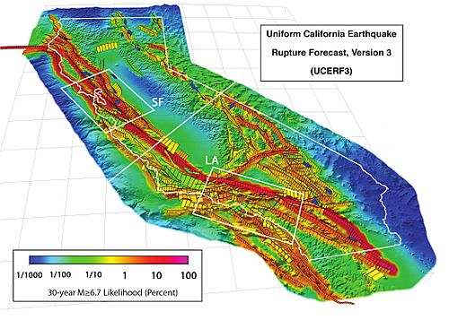
The Ridgecrest earthquakes happened in an area called the Eastern California Shear Zone (ECSZ). This area is east of the famous San Andreas Fault. It has many strike-slip faults that run in the same direction as the San Andreas Fault.
The Garlock Fault crosses this area, about 24 kilometers (15 miles) south of Ridgecrest. This fault is one of California's longest active faults. It marks a boundary where the ground moves in different ways.
The ECSZ extends north along the Sierra Nevada Mountains. This is where the Sierra Nevada microplate is slowly pulling away from the North American continent. About a quarter of the movement between the Pacific Plate and North America happens in this zone. Scientists think that eventually, this movement will create a new big fault that will take over from the San Andreas Fault.
The Little Lake Fault, where the 2019 Ridgecrest earthquakes happened, runs under the Naval Weapons Center. The quakes' centers were mainly under this base, where the Little Lake Fault meets the Airport Lake Fault Zone.
Scientists are still studying how the Garlock Fault connects with other faults in the area. It's a complex system, and understanding it helps predict future earthquakes.
Past Earthquakes in the Area
The Eastern California Shear Zone has had many large earthquakes throughout history. One of the biggest was the 1872 Owens Valley earthquake, which was estimated to be a 7.4 magnitude quake. It is thought to be the strongest earthquake ever recorded in California and the western United States.
Other notable earthquakes include:
- A 6.3 magnitude quake near Walker Pass in March 1946.
- The 1952 Kern County earthquake, a 7.3 magnitude quake, which was the biggest in California since the 1906 San Francisco earthquake.
- The 1992 Landers earthquake, a 7.2 magnitude quake, also the strongest in California since 1906. It was followed by the 1999 Hector Mine earthquake, a 7.2 magnitude quake on a nearby fault.
Smaller earthquakes are very common in the Ridgecrest area. For example, in October 1961, a 5.2 magnitude quake hit near Ridgecrest. The area is known for "earthquake swarms," which are thousands of small earthquakes that can last for over a year.
The Ridgecrest earthquakes in 1995 were similar to the 2019 events. They also had two main quakes: a 5.4 magnitude quake in August and a 5.8 magnitude quake in September. Scientists have noticed that earthquake sequences in this area tend to get bigger and move southward over time.
|
See also
 In Spanish: Terremotos de Ridgecrest de 2019 para niños
 | Lonnie Johnson |
 | Granville Woods |
 | Lewis Howard Latimer |
 | James West |


