
Ackerly Creek facts for kids
Quick facts for kids Ackerly Creek |
|
|---|---|
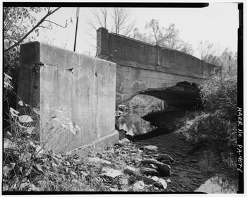
Ackerly Creek at the Ackerly Creek Bridge
|
|
| Physical characteristics | |
| Main source | unnamed lake and swamp in South Abington Township, Lackawanna County, Pennsylvania between 1,420 and 1,440 feet (433 and 439 m) |
| River mouth | South Branch Tunkhannock Creek in La Plume Township, Lackawanna County, Pennsylvania between 820 and 840 feet (250 and 256 m) 41°33′34″N 75°46′20″W / 41.55934°N 75.77226°W |
| Length | 8.7 mi (14.0 km) |
| Basin features | |
| Progression | South Branch Tunkhannock Creek → Tunkhannock Creek → Susquehanna River → Chesapeake Bay |
| Basin size | 18 sq mi (47 km2) |
| Tributaries |
|
Ackerly Creek is a cool stream, or tributary, located in Lackawanna County, Pennsylvania. It flows into the South Branch Tunkhannock Creek. This creek is about 8.7 miles (14 km) long. It winds through several towns like South Abington Township, Waverly Township, Glenburn Township, Dalton, and La Plume Township.
Many smaller streams flow into Ackerly Creek. The area it drains, called its watershed, is almost 18 square miles (47 km²). Even though Ackerly Creek is not officially listed as a "problem" water body, it does have some water quality issues. Part of the creek flows through a special nature area called Rabbit Hollow. The creek also faces some erosion because its banks have been changed and straightened where it runs next to US Route 6 and US Route 11.
The land around Ackerly Creek is mostly suburban, with homes and neighborhoods. It's the most developed part of the larger Tunkhannock Creek watershed. There was once a site in the watershed that needed a big cleanup. Many historic places are found near the creek, and an old bridge that is part of the Historic American Engineering Record crosses it. Ackerly Creek's watershed is a great place for trout and other fish. It also has many fun places for people to visit and enjoy nature.
Contents
Where Ackerly Creek Flows
Ackerly Creek starts in an unnamed lake in South Abington Township. It flows southwest for a short distance. Then it turns northwest and enters Waverly Township. The creek then flows west-southwest for over a mile. It passes near the town of Waverly and crosses Pennsylvania Route 407.
After that, the creek briefly turns west-northwest. It then turns west-southwest again, crossing a railroad. It then enters Glenburn Township and the town of Glenburn. Here, it turns north for a short distance. Finally, it turns west across US Route 11 and flows into Glenburn Pond.
From the northern end of Glenburn Pond, Ackerly Creek flows north-northwest. It runs alongside US Route 11 for a few miles, going through Dalton. Then it enters La Plume Township. In La Plume, the creek turns west for a short bit. It then turns northwest for several tenths of a mile. After that, it turns west again, then south, and finally west one more time. At this point, it meets the South Branch Tunkhannock Creek.
Ackerly Creek joins the South Branch Tunkhannock Creek about 7.54 miles (12.13 km) before that creek reaches its own end.
Smaller Streams Joining Ackerly Creek
Ackerly Creek does not have any named smaller streams, or tributaries. However, many unnamed streams flow into it from both sides. One important branch of the creek starts near Florey's wetlands. It flows from Gravel Pond to Glenburn Pond.
Water Quality of Ackerly Creek
Ackerly Creek itself is not listed as a "problem" water body. However, one of its unnamed smaller streams is. The Pennsylvania Department of Environmental Protection says that Ackerly Creek's watershed is the most "stressed" (meaning it has the most water quality issues) in the whole Tunkhannock Creek area. Back in the 1970s, Ackerly Creek was in good shape. But even then, the water flow was very low at its beginning.
Some spots in the Ackerly Creek watershed have too much ammonia, phosphates, and nitrates. These can be harmful to water life. Ackerly Creek is an intermittent stream, meaning it sometimes dries up in parts. Its watershed is the only one in the Tunkhannock Creek area that has big water quality problems from cities and suburbs. There are also issues with stormwater runoff in the watershed.
Keystone College has a special lab that studies water and land (called hydrogeology) right on Ackerly Creek.
Land and Features Around Ackerly Creek
The lowest point of Ackerly Creek, where it meets another stream, is about 820 to 840 feet (250 to 256 meters) above sea level. The highest point, where it begins, is about 1420 to 1440 feet (433 to 439 meters) above sea level.
In one section, Ackerly Creek flows through a shallow valley called Rabbit Hollow. Long ago, a dam was built here to create a pond, but the pond is no longer there.
Where Ackerly Creek flows next to US Route 6 and US Route 11, its banks have been changed and straightened. This causes a lot of erosion along the creek. There are about a dozen spots where the creek banks are unstable. Several bridges also cross the creek. Luckily, there isn't much garbage found along the creek.
Most of the Ackerly Creek watershed doesn't have a lot of paved surfaces. But one area in the very south has about 40 percent paved surfaces. The creek has a wide and developed floodplain in Dalton. At least one railroad bridge crosses the creek.
Ackerly Creek's Watershed
The watershed of Ackerly Creek covers about 18 square miles (47 km²). Ackerly Creek flows through the Dalton area on maps. This watershed is the southernmost part of the larger Tunkhannock Creek area. Many towns are in the creek's watershed, including La Plume Township, Dalton, Waverly Township, and Clarks Summit.
The Ackerly Creek watershed has the most people and development in the entire Tunkhannock Creek area. It used to be mostly rural, but now it's becoming more suburban with many homes. However, you can still find both rural and heavily developed areas here. There was once a site called Precision Plating in the watershed that needed a big environmental cleanup. Overall, the watershed's physical condition is considered "fair, bordering on good."
There is a swamp where Ackerly Creek begins.
History and Fun Activities
Ackerly Creek was officially named in the Geographic Names Information System on August 2, 1979.
Historically, the area around Ackerly Creek was a safe place for escaped slaves. Many historic sites are in the creek's watershed. These include the Abington Baptist Church, Keystone College, and the Ackerly Fairgrounds. The Delaware, Lackawanna and Western Railroad used to run through the creek's valley.
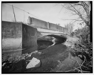
An old bridge called the Ackerly Creek Bridge was built in 1904. This bridge is listed in the Historic American Engineering Record. Newer bridges have also been built over the creek, like one in 2006 and another in 2008. A special three-part tunnel, called a triple-barrel culvert, carries the creek under US Route 6.
Between 1972 and 1993, a company had permission to release industrial waste into a swamp at the beginning of Ackerly Creek.
In 1999, a group called the Land and Water Committee of the Countryside Conservancy started studying the Ackerly Creek watershed. In 2007, there were plans to remove the Glenburn Pond Dam on the creek. This project would help restore 20 acres (8.1 ha) of wetlands and natural areas along the creek banks. Keystone College even received a grant to help restore these areas.
Animals and Plants of Ackerly Creek
The main part of Ackerly Creek is known as a good place for trout fishing. Its smaller, unnamed streams are also good for coldwater fish. In the 1990s, a small population of trout lived in the creek. Many different animals live here, including fourteen types of salamanders, thirteen types of snakes, ten types of frogs and toads, and four types of turtles.
In Rabbit Hollow, where Ackerly Creek flows, you can find many bird species. These include the Louisiana waterthrush, Cooper's hawk, wood thrush, and belted kingfisher. Mammals living in the hollow include rabbits, woodchucks, chipmunks, squirrels, and white-tailed deer.
The natural area along the creek banks, called the riparian buffer, varies in thickness. In some places, it's less than 30 feet (9.1 m) wide, while in others, it's over 100 feet (30 m) wide. Unfortunately, Invasive species (plants that don't belong there and can harm the environment) grow along much of Ackerly Creek. However, Rabbit Hollow is home to many native plants, including trees, shrubs, and wildflowers.
Fun Things to Do at Ackerly Creek
There are many fun places to visit, both public and private, in the Ackerly Creek watershed. Some major spots include:
- The Ackerly Playing Fields
- The 16-acre (6.5 ha) Rabbit Hollow Sanctuary, perfect for quiet walks and watching nature
- The Dalton Streamside Park
- The private Glen Oaks Country Club
- Glenburn Pond
The Rabbit Hollow preserve was given to The Nature Conservancy in 1975. It became a preserve in 1977 and is now owned by Abington Township.
A walking trail called The Trolley Trail is also in the Ackerly Creek watershed. It follows the path of the old Northern Electric Trolley Line.
