
South Branch Tunkhannock Creek facts for kids
Quick facts for kids South Branch Tunkhannock Creek |
|
|---|---|

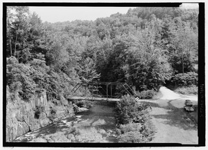
South Branch Tunkhannock Creek looking downstream at Little Rocky Glen
|
|
| Physical characteristics | |
| Main source | pond or small lake between Hubbard Mountain and Meyers Mountain in Scott Township, Lackawanna County, Pennsylvania between 1,380 and 1,400 feet (421 and 427 m) |
| River mouth | Tunkhannock Creek at Bardwell in Tunkhannock Township, Wyoming County, Pennsylvania 627 ft (191 m) 41°33′46″N 75°52′31″W / 41.5627°N 75.8754°W |
| Length | 22.5 mi (36.2 km) |
| Basin features | |
| Progression | Tunkhannock Creek → Susquehanna River → Chesapeake Bay |
| Basin size | 98.3 sq mi (255 km2) |
| Tributaries |
|
The South Branch Tunkhannock Creek is a tributary (a smaller stream that flows into a larger one) of Tunkhannock Creek in Lackawanna County and Wyoming County, Pennsylvania. It is about 22.5 miles (36.2 km) long. This creek flows through several towns and townships in both counties.
The area around the creek, called its watershed, covers about 98.3 square miles (255 km2). The creek has three main smaller streams that feed into it: Trout Brook, Ackerly Creek, and Kennedy Creek. The South Branch Tunkhannock Creek has good water quality and is not considered a polluted waterway.
The land around the creek is "rough and hilly." The ground is made of different layers of sedimentary rock. There's even a deep gorge about 100 feet (30 m) deep along the creek. Most of the land in the watershed is covered by forests or farms. Some natural gas drilling also happens here. In the past, farming and summer resorts were important industries. The Delaware, Lackawanna and Western Railroad also used to pass through this area.
The main part of the South Branch Tunkhannock Creek is a special place for trout fishing. It's known as a Trout Stocked Fishery and a Migratory Fishery. The creek is home to many different kinds of aquatic life. People also stock it with trout for fishing. You can even canoe on some parts of the creek. It flows through Lackawanna State Park, making it a great spot for outdoor fun.
Contents
Journey of the Creek

The South Branch Tunkhannock Creek starts in a pond or small lake. This is in Scott Township, Lackawanna County, between Hubbard Mountain and Meyers Mountain. It flows northwest through a valley, following Pennsylvania Route 247 for a bit. Then it crosses the highway.
The creek continues north-northwest for a few miles, alongside Pennsylvania Route 438. It then turns northwest, still near Route 438. After a short distance, it slowly turns southwest. It crosses Interstate 81 and leaves Route 438 behind. The creek then flows along the edge of Benton Township and North Abington Township. It turns west-northwest and flows into Lackawanna Lake. Here, it meets Kennedy Creek, its first named tributary, coming from the left side.
From Lackawanna Lake, the creek flows northwest for over a mile. Then it turns west for a few miles and enters La Plume Township. It briefly flows along the border between Lackawanna and Wyoming counties. It crosses US Route 6 and gets water from Ackerly Creek, a tributary from the right. The creek then flows west, leaving Lackawanna County.
When it leaves Lackawanna County, the South Branch Tunkhannock Creek enters Factoryville, Wyoming County. It flows northwest here before entering Clinton Township. It turns southwest, then northwest, and then winds west-southwest alongside US Route 6. In this area, it receives Trout Brook from the left. Finally, it turns west, enters Tunkhannock Township, and winds west-northwest. After crossing US Route 6 again, it joins the main Tunkhannock Creek.
The South Branch Tunkhannock Creek joins Tunkhannock Creek about 6.40 miles (10.30 km) before Tunkhannock Creek reaches its own end.
Creek's Smaller Streams
The South Branch Tunkhannock Creek has three named smaller streams that flow into it. These are Kennedy Creek, Ackerly Creek, and Trout Brook. Kennedy Creek joins the South Branch Tunkhannock Creek about 12.82 miles (20.63 km) upstream from its mouth. It drains an area of 6.17 square miles (16.0 km2). Ackerly Creek joins the South Branch Tunkhannock Creek about 7.54 miles (12.13 km) upstream from its mouth.
Water Quality and Flow
The South Branch Tunkhannock Creek generally has good water quality. It is not listed as a polluted waterbody. However, some smaller streams in its watershed, especially above Factoryville, do have issues. These problems can come from unknown sources, urban runoff (water flowing from cities), or pollution from specific points like factories.
Things like urban sprawl (cities spreading out) and poorly managed stormwater (rainwater runoff) can affect the creek. Runoff can also impact the floodplains (flat land next to the river), streambanks (sides of the river), and the stream channel (the path the river takes).
Near Factoryville, the creek's average water flow is about 102.4 cubic feet per second (2.90 m3/s) each year. It takes about 22 hours for water to travel from the creek's start to this point. The amount of water that refills the creek each month changes. It's lowest in August (1.8 percent) and highest in March (19.2 percent). In the 1970s, the water temperature near Tunkhannock ranged from 4 to 22 °C (39 to 72 °F).
Scientists have measured different things in the creek's water over the years. They look at how clear the water is (turbidity), how well it conducts electricity (specific conductance), and how much solid material is floating in it. They also check the water's pH (how acidic or basic it is), the amount of dissolved oxygen (which fish need to breathe), and other chemicals like carbon dioxide and bicarbonate.
The creek's water also contains tiny amounts of various elements. These include magnesium, calcium, sodium, and potassium. There are also very small traces of metals like iron and manganese. These measurements help scientists understand the health of the creek's ecosystem.
The highest amount of water the creek is expected to carry in a year (a 1 percent chance of happening) varies along its path. For example, near the Pennsylvania Route 438 bridge, it could reach 2,460 cubic feet per second (70 m3/s).
Land, Rocks, and Weather
The land around the South Branch Tunkhannock Creek is quite "rough and hilly." The creek's mouth is about 627 feet (191 m) above sea level. Its source is much higher, between 1,380 and 1,400 feet (420 and 430 m) above sea level. The creek drops quite a bit in elevation as it flows.
The ground beneath the watershed is mostly made of sedimentary rock layers. In the upper part of the watershed, the ground is entirely made of shale and sandstone rocks.
The valley where the creek flows is surrounded by steep hills. Some parts have flat floodplains next to the water. Many small lakes and swamps are scattered throughout the watershed. A mountain called Tunkhannock Mountain is nearby.
The creek's stream channel (its path) is winding. It flows through glacial drift (material left by glaciers) and rock formations made of sandstone. The creek has many "rock gardens" and areas where the water flows over small rocks (called riffles). There are also several rock ledges, including a very large one.
A special feature is a 100-foot (30 m) deep gorge carved through sandstone and shale. In this gorge, the creek has carved out pools and flows through narrow gaps. There's even a mushroom-shaped rock sticking out in the gorge!
The area around the creek usually gets about 35 to 40 inches (89 to 102 cm) of rain each year.
Creek's Surroundings
The watershed of South Branch Tunkhannock Creek covers 98.3 square miles (255 km2). Most of this area is in northwestern Lackawanna County and northeastern Wyoming County. A small part is in southern Susquehanna County.
The creek's mouth is in the Tunkhannock quadrangle (a map section). Its source is in the Carbondale quadrangle. The creek also flows through the Dalton and Factoryville quadrangles. The mouth of the creek is at a place called Bardwell. The creek generally flows west, but its path is quite winding.
In the part of the watershed above Factoryville, there are about 123.5 miles (198.8 km) of streams. There are also more than twenty named ponds, lakes, and swamps, plus many unnamed ones.
As of 2010, about 15,897 people lived in the watershed area above Factoryville. This area is growing fast in terms of population. In 2006, most of the land was forest (54.66 percent) or agricultural land (32.42 percent). Other uses included developed areas, grasslands, water, and wetlands. The creek itself mostly flows through quiet, forested areas, except when it goes through Factoryville. It also flows alongside the busy US Route 6 for a long distance.
There are a few natural gas drilling sites in the watershed upstream of Factoryville. However, no water is taken from the creek for natural gas use. The public water supply in this area comes from groundwater. There are also several sites that discharge treated wastewater or stormwater into the watershed.
Keystone College is located in the watershed of South Branch Tunkhannock Creek, near where Ackerly Creek joins it. The creek is part of the beautiful Endless Mountains region of Pennsylvania.
History of the Area
The South Branch Tunkhannock Creek was officially added to the Geographic Names Information System on August 2, 1979.
European settlers first came to Factoryville, a town on the creek, in the early 1800s. In the mid-1810s, a textile mill powered by the creek's water was built there. A historic bridge, the Slates' Mill Bridge, was built in 1885. It carries Township Road 439 over the creek in Benton Township.
In the early 1900s, the main jobs in the creek's watershed were agriculture and working at summer resorts. The Delaware, Lackawanna and Western Railroad also passed through the area. The creek's water also powered mills that made flour and cut lumber in towns like Laplume, Dalton, and Factoryville. The main towns back then included Dalton, Factoryville, Glenburn, Fleetville, Laplume, Bardwell, and East Benton.
In 2003, a group of local citizens formed the South Branch Tunkhannock Creek Watershed Coalition. They work to protect the creek and its surroundings. Since 2004, they have been checking the water quality every month. They measure things like water temperature, pH, dissolved oxygen, and levels of nitrates and orthophosphates. Since 2005, they also check the macroinvertebrates (small creatures without backbones) in the watershed twice a year.
Animals and Plants
The main part of the South Branch Tunkhannock Creek is a special place for fish. It's called a Trout-Stocked Fishery and a Migratory Fishery. This means it's a good place for trout, and other fish travel through it. Even Ackerly Creek, one of its tributaries, has these same designations. The Pennsylvania Fish and Boat Commission lists the creek as Approved Trout Waters.
In some parts of the creek, special fishing rules apply, like "Delayed Harvest Artificial Lures Only." This means you can only use artificial bait and must release the fish after catching them. The Pennsylvania Fish and Boat Commission has put Brown trout and rainbow trout into the creek to help with fishing.
The South Branch Tunkhannock Creek is home to many different kinds of aquatic fauna (water animals).
You can find forests of eastern hemlock trees near the creek, especially around Little Rocky Glen. Ferns also grow on the rock ledges there.
Fun Activities

You can go canoeing on at least 10.0 miles (16.1 km) of the South Branch Tunkhannock Creek. The best times are during snowmelt or within three days after heavy rain. The creek is usually easy to paddle, but there's one exciting rapid (fast-flowing water) at Little Rocky Glen. The scenery along the creek is described as "good" for canoeing.
The South Branch Tunkhannock Creek is popular with people who like to kayak and fish. However, the water at Little Rocky Glen can be very powerful, and it's important to be careful there.
Lackawanna State Park is located in the watershed of South Branch Tunkhannock Creek. A small nature preserve called Little Rocky Glen is also on the creek. It has some easy to moderate paths for hiking, but no official trail system. There are also longer hiking trails near the creek in Lackawanna State Park, like the North Woods Trail and the Lackawanna Lake Loop.
Many people describe the South Branch Tunkhannock Creek as "beautiful," especially when it flows through Lackawanna State Park.
