Amambay Department facts for kids
Quick facts for kids
Amambay Department
Departamento de Amambay
|
|||
|---|---|---|---|
|
|||
| Etymology: Guarani: Amambái (eagle fern) | |||

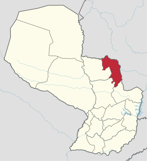
Amambay shown in red
|
|||
| Country | |||
| Region | Eastern Region | ||
| Established | 1945 | ||
| Capital | Pedro Juan Caballero | ||
| Largest city | Pedro Juan Caballero | ||
| Area | |||
| • Total | 12,935 km2 (4,994 sq mi) | ||
| Area rank | 9 | ||
| Population
(2009)
|
|||
| • Total | 156,248 | ||
| • Rank | 13 | ||
| • Density | 12.0795/km2 (31.2857/sq mi) | ||
| Time zone | UTC-04 (AST) | ||
| • Summer (DST) | UTC-03 (ADT) | ||
| ISO 3166 code | PY-13 | ||
| Number of Districts | 5 | ||
| Website | amambay.gov.py | ||
Amambay (pronounced ah-mahm-BUY) is a special area, like a state, in Paraguay. Its main city and capital is Pedro Juan Caballero.
The name "Amambay" comes from the Amambai Mountains. It's also the name of a type of fern that grows a lot in the forests there.
Contents
- What are the Districts of Amambay?
- A Look at Amambay's History
- Where is Amambay Located?
- What is Amambay's Climate Like?
- Mountains and Land in Amambay
- Rivers and Waterways
- Amambay's Natural Environment
- Tourism and Fun in Amambay
- Amambay's Economy
- Getting Around and Services
- Education in Amambay
- Health Care
- See also
What are the Districts of Amambay?
The Amambay department is split into six smaller areas called districts:
- Bella Vista
- Capitán Bado
- Karapaí
- Pedro Juan Caballero
- Zanja Pytá
- Cerro Corá
A Look at Amambay's History
For a long time, native people lived on this land. They faced attacks from groups called Bandeirantes. These groups were looking for the Guaraní people, who found safety in the area's thick jungles.
After the Paraguayan War, large parts of the land were bought by foreign business people. They focused on collecting yerba mate and cutting down trees for wood.
The city of Pedro Juan Caballero was founded in 1893. Then, Bella Vista was founded in 1902. The Amambay department was officially created in 1945. It was first the 10th department, but after some changes, it became the 13th.
More people moved to the area as small farming communities grew. These communities focused on growing crops and raising animals.
Pedro Juan Caballero, the capital city, is still known by its old name, Punta Porá. This name was used by traders who moved yerba from Mato Grosso to Concepción.
Where is Amambay Located?
Amambay is in the northern part of Paraguay's Eastern Region. It shares borders with other areas.
Its borders are:
- To the North: Brazil. The Apa River and the Amambay Mountains separate it from Brazil.
- To the South: Canindeyú Department.
- To the East: Brazil. The Amambay Mountains also form this border.
- To the West: Concepción and San Pedro departments.
What is Amambay's Climate Like?
The average temperature in Amambay is 21°C (70°F). In summer, it can get as hot as 35°C (95°F). In winter, temperatures can drop to -1°C (30°F). The rainiest months are January, February, and March.
Mountains and Land in Amambay
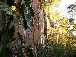
The land in Amambay is mostly made of sandstone and rocks, stretching from north to south.
Amambay has some of the highest land in Paraguay. It reaches 300 to 400 meters (984 to 1,312 feet) high. The Punta Porá Hill is even taller, reaching 700 meters (2,296 feet). The Amambay Mountains form a natural border with Brazil. From these mountains, smaller mountain ranges branch off, like Cerro Corá, Tacurupytá, Guasú, Alambique, Tuna, and Tangaró.
Some hills that stand alone are Tranquerita, Tacuara, Verón Cué, and Cuatiá.
Rivers and Waterways
The Apa River marks the northern border of Amambay. The Estrella Stream also forms a border with Brazil. Other important rivers in Amambay include the Aquidabán River and streams like Tapiracuai, Aquidabán-mi, Cabayu, and Guazú.
The western side of the department is bordered by the Ypané River. Other waterways in this area are Tutytí, Aguaray Verde, Puente de la Tabla Puendy, and Ypané-mi.
Amambay's Natural Environment
The whole department is part of the Amambay Ecological Region. This area has many different types of animals and plants.
Because of its rich natural resources, the department has seen a lot of trees cut down. Some plants that are now in danger of disappearing include local palm trees, karanday (a type of palm), array, the Amambay fern, trébol, yvyra paje, kai kygua, and local cedars.
Also, some animal species are in danger, such as the agua’a sayju, jacaré ita, and guasuti.
There are several protected areas to help save nature:
- Estrella Forest: 30,000 hectares
- Pira’y Forest: 22,500 hectares
- Guasú Hill: 15,000 hectares
- Sarambí Hill: 15,000 hectares
The Cerro Corá National Park was created in 1976. It covers 12,038 hectares and is located in the Pedro Juan Caballero district.
Tourism and Fun in Amambay
Amambay is a beautiful place with lots of natural sights. The Amambay Mountains form a chain of hills like Cerro Corá, Tacurý Pytá, Guasú, and Alambique. The most important hills are Cerro Corá (in the National Park), Acuá, Lorito, Guasú, Muralle, and Sarambí.
In Cerro Corá, near the Aquidabán Nigui River, an important historical event happened in 1870. Marshal Francisco Solano López died there in the Battle of Cerro Corá. There is a monument to him in the National Park.
At Cerro Guasú, Yasuká Verá, you can find caves and old human tools. These items are very old, dating back 2,500 to 3,800 years.
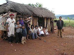
Tapé Tuyá is a road that the remaining Paraguayan army used in a campaign from 1869-1870. This area was home to native groups from the Tupí Guaraní family, like the Paí Tavyterá and Ava Guaraní. There is a hill there that the Ava Guaraní considered a holy place. They believed it was the center of the earth, where the world was created and where the first man and woman were born.
In Pedro Juan Caballero, the beaches along the Aquidabán River are very pretty and attract many visitors. The city's shopping centers are also popular.
The beaches in Bella Vista are also a favorite spot for tourists.
Amambay's Economy
Amambay has a lot of trade because it borders Brazil.
In Paraguay's economy, Amambay is the sixth-largest area for raising cattle. It also produces 2% of the country's cotton.
Farmers in the region grow many crops, including garlic, cotton, rice, beans, banana, sweet potato, coffee, sugar cane, onion, sunflower, lemon, maize, tangerine, manioc, peanut, mint, sour and sweet orange, potato, pineapple, grapefruit, soy, tobacco, sorghum, tartago, tomato, yerba mate, and carrot.
People also raise various animals, such as cows, horses, sheep, and goats. They also raise birds like chickens, guinea fowl, turkeys, geese, and ducks.
The most important industries in Amambay are food processing, dairy, mills, yerba industries, and sawmills. There is also a very modern ceramic factory in Itapopó.
Every October, the Expo Amambay is held. It's a fair that showcases local industries, businesses, and services.
Getting Around and Services
The main way to get to Amambay is by Route No. 5 "Gral. Bernardino Caballero." This route connects to Concepción and then joins Route No. 3 "Gral. Elizardo Aquino," which goes to Asunción and Cnel. Oviedo. Route No. 11 "Juana de Lara" reaches Capitán Bado.
The department has both paved and gravel roads. The International Route that connects Pedro Juan Caballero – Capitán Bado with Brazil is used a lot for business.
The "Dr. Augusto R. Fuster" airport in Pedro Juan Caballero has regular flights to Asunción.
Amambay has several radio stations, including La Voz del Amambay and Mcal. López on AM. On FM, there are Pantanal, Amambay, Cerro Corá, Frontera, Capitán Bado, and Sin Frontera. There are also television stations and a telephone center.
There are 23,921 homes in the department. About 16,174 are in cities, and 7,747 are in rural areas. Here's how many homes have basic services:
- Electricity: 56.3%
- Running water: 21%
- Trash collection: 37.7%
Education in Amambay
In Amambay, there are 33 schools for elementary education. There are also 188 schools for basic education and 28 high schools, following Paraguay's education system.
Health Care
The department has a total of 22 health care places, including hospitals and clinics.
See also
 In Spanish: Departamento de Amambay para niños
 | Valerie Thomas |
 | Frederick McKinley Jones |
 | George Edward Alcorn Jr. |
 | Thomas Mensah |


