
Arlington, Washington facts for kids
Quick facts for kids
Arlington, Washington
|
|||
|---|---|---|---|

Olympic Avenue in downtown Arlington
|
|||
|
|||

Location of Arlington within Snohomish County
|
|||

Arlington, Washington
Location in Washington (state)

Arlington, Washington
Location in the United States

Arlington, Washington
Location in North America
|
|||
| Country | United States | ||
| State | Washington | ||
| County | Snohomish | ||
| Incorporated | May 20, 1903 | ||
| Government | |||
| • Type | Mayor–council | ||
| Area | |||
| • Total | 9.81 sq mi (25.4 km2) | ||
| • Land | 9.80 sq mi (25.4 km2) | ||
| • Water | 0.01 sq mi (0.03 km2) | ||
| Elevation | 115 ft (35 m) | ||
| Population
(2020)
|
|||
| • Total | 19,868 | ||
| • Estimate
(2022)
|
21,059 | ||
| • Density | 2,024.45/sq mi (781.64/km2) | ||
| Time zone | UTC-8 (PST) | ||
| • Summer (DST) | UTC-7 (PDT) | ||
| ZIP code |
98223
|
||
| Area code | 360 | ||
| FIPS code | 53-02585 | ||
| GNIS feature ID | 1515947 | ||


Arlington is a city in northern Snohomish County, Washington, in the Seattle metropolitan area. It sits by the Stillaguamish River, close to the Cascade Range mountains. The city is about 10 miles (16 km) north of Everett and 40 miles (64 km) north of Seattle. In 2020, Arlington had a population of 19,868 people.
The land where Arlington is now was traditionally home to the Stillaguamish people, a Native American group. Settlers started the town in the 1880s, and it officially became a city in 1903. During the 1930s, big projects helped people find jobs, including building an airport. This airport later became a naval air station during World War II. Starting in the 1980s, Arlington grew a lot as more people moved to the suburbs. It even added the area of Smokey Point to its city limits.
Arlington's economy used to be all about timber (wood) and agriculture (farming). Now, it focuses more on services and some aviation (airplane) jobs near the airport. The city is run by a mayor–council government, with a mayor and seven city council members. The city government takes care of parks and water services. Other services, like public transportation and schools, are handled by larger regional groups.
Contents
History of Arlington
Early History and Native Peoples
The Coast Salish people have lived in the Puget Sound region for about 12,000 years. The Stillaguamish people traditionally lived in the area where Arlington is today. They had many villages along the Stillaguamish River. One important village was called sq'ʷuʔalqʷuʔ (meaning "confluence"), where the two forks of the river meet. About 200-300 people lived there in winter.
American explorers arrived in 1851. The area became open for logging after a treaty was signed in 1855. The Stillaguamish tribe was told to move to a reservation, but many stayed on their traditional lands. They were officially recognized by the government in 1976.
In the 1880s, roads were built to the area, bringing people who worked in logging. The first store opened in 1888.
How Arlington Started

Two towns began on the south side of the river, hoping a railroad would come through. G. Morris Haller started "Haller City" in 1883. But the railroad built its station on higher ground, so a new town called "Arlington" was started there on March 15, 1890. Arlington was named after Lord Henry Arlington from England.
Arlington and Haller City grew quickly, reaching 500 people by 1893. They relied on farming and making wood shingles. Both towns had their own schools, stores, and churches. Eventually, Arlington became bigger and Haller City was absorbed into it. Today, Haller City is remembered by a park and a middle school in Arlington.
Becoming a City and Growth

Arlington officially became a city on May 20, 1903. John M. Smith was elected as the first mayor. After becoming a city, Arlington got a bank, a creamery (for dairy products), a park, a library, electricity, and phone service.
In the early 1900s, wood mills were the biggest employers. During the Great Depression in the 1930s, most mills closed. The government created programs like the Civilian Conservation Corps (CCC) to provide jobs. These programs helped build sidewalks, a high school, and the municipal airport, which opened in 1934.
During World War II, the U.S. Navy took over the airport and made it a naval air station. After the war, the city got the airport back in 1959.
Modern Arlington
In the late 1960s, new highways like Interstate 5 and State Route 9 brought more people to Arlington. It became a "bedroom community," meaning many residents worked in nearby cities like Everett and Seattle. Arlington's population grew by over 450 percent by 2007. In 1999, the city added Smokey Point to its area.
Arlington celebrated its 100th birthday in 2003 with a big parade and festival. In 2007, downtown Arlington's Olympic Avenue was improved, which helped bring new life to the area.
On March 22, 2014, a huge mudslide happened near Oso, killing 43 people. Arlington became the center for helping with the disaster. U.S. President Barack Obama even visited Arlington to see the site.
The city continues to grow. In 2019, the Cascade Industrial Center was created between Arlington and Marysville to bring more manufacturing and industrial jobs. In 2023, a very large Amazon distribution center opened near the airport, creating 1,200 jobs.
Arlington's Geography

Arlington covers about 9.26 square miles (24.0 km2). It's in the northwest part of Snohomish County. The city is about 41 miles (66 km) north of Seattle. Arlington's borders are generally Marysville to the south, Interstate 5 to the west, the Stillaguamish River valley to the north, and the Cascade Range foothills to the east.
The city sits on land shaped by glaciers long ago. Downtown Arlington is on a bluff above where the Stillaguamish River's North and South Forks meet. From Arlington, you can see the Olympic Mountains, Mount Pilchuck, and Mount Rainier.
Neighborhoods in Arlington
Arlington has several different areas, each with its own feel:
- Old Town: This is downtown Arlington and the older neighborhoods built in the early 1900s.
- Arlington Bluff: A residential area between the river and the airport's industrial center.
- Kent Prairie: A residential area south of Old Town, with some retail stores. This area was once a Native American village.
- Manufacturing Industrial Center: This area is southwest of Old Town, around the Arlington Municipal Airport.
- Hilltop: This area has Arlington's largest planned neighborhoods, like Gleneagle, which has over 1,000 homes and a golf course.
- Smokey Point: This is a big commercial and residential area at the junction of Interstate 5 and State Route 531. Arlington added it in 1999.
Arlington's Climate
Arlington has a climate similar to most of the Puget Sound area. Summers are dry, and winters are mild and rainy. Most of the rain falls in winter and early spring. Arlington gets about 46 inches (117 cm) of rain each year. It doesn't get much snow, averaging about 7 inches (18 cm) per year.
July is the warmest month, with average high temperatures around 77.3°F (25.2°C). January is the coolest, with average highs around 45.3°F (7.4°C). The highest temperature ever recorded was 103°F (39°C) on June 28, 2021.
Arlington's Population
| Historical population | |||
|---|---|---|---|
| Census | Pop. | %± | |
| 1910 | 1,476 | — | |
| 1920 | 1,418 | −3.9% | |
| 1930 | 1,439 | 1.5% | |
| 1940 | 1,460 | 1.5% | |
| 1950 | 1,635 | 12.0% | |
| 1960 | 2,025 | 23.9% | |
| 1970 | 2,261 | 11.7% | |
| 1980 | 3,282 | 45.2% | |
| 1990 | 4,037 | 23.0% | |
| 2000 | 11,713 | 190.1% | |
| 2010 | 17,926 | 53.0% | |
| 2020 | 19,868 | 10.8% | |
| 2021 (est.) | 20,075 | 12.0% | |
| Source: U.S. Decennial Census | |||
In 2020, Arlington had 19,868 people, making it the tenth largest city in Snohomish County. Between 1980 and 2010, Arlington's population grew by over 450 percent. This growth was due to new suburban homes and adding nearby areas to the city. In July 2022, the city's population was estimated to be 21,059.
Who Lives in Arlington?
Based on the 2010 census:
- There were 17,926 people living in Arlington.
- About 85.6% of residents were White.
- About 9.5% of the population was Hispanic or Latino.
- The average age in the city was 34.3 years old.
- About 28.3% of residents were under 18.
- The city had slightly more females (51.4%) than males (48.6%).
Arlington's Economy
As of 2015, about 9,481 Arlington residents were working or looking for work. Most people (85%) drove alone to their jobs. Only 12% of employed Arlington residents worked within the city. Many commuted to Everett (17%), Seattle (9%), or Marysville (8%).
The biggest industries for Arlington workers are education and health care (19%), manufacturing (18%), and retail (11%).
Arlington's economy used to depend on cutting and processing timber. It was even called the "Shingle Capital of the World." Farming and dairy also became important.
Now, Arlington has a "service economy." Many residents work for large companies like Boeing Everett Factory and Naval Station Everett. The municipal airport has become a center for aerospace jobs, with many companies that work with Boeing. In 2012, the airport had 130 businesses employing 590 people.
The city plans to have over 20,000 jobs by 2035. The Cascade Industrial Center, located near Smokey Point, is helping with this goal. In 2023, a huge Amazon distribution center opened there, creating 1,200 jobs.
City Government and Politics

Arlington has a mayor–council government. This means there's an elected mayor and an elected city council. The mayor serves a four-year term. Don Vanney became mayor in 2023.
The city council has seven members who are elected for four-year terms. They also hire a city administrator to manage daily city operations. The council meets twice a month at city hall. Arlington's city government has 128 full-time employees and a yearly budget of about $50 million.
The city government provides emergency services, water and sewer services, street maintenance, parks, an airport, and a cemetery. In 2021, Arlington's fire department joined the North County Regional Fire Authority.
Arlington is part of Washington's 1st congressional district for federal elections. For state elections, it's in the Washington's 10th legislative district.
Culture and Fun in Arlington
Art and Creativity
Arlington has a rule that 1% of the budget for new public construction projects must go towards public art. The Arlington Arts Council has helped get 30 sculptures and murals for the city's Sculpture Walk in downtown and along the Centennial Trail.
The Arlington High School has a performing arts center called the Byrnes Performing Arts Center. An arts and crafts festival is held every year at Legion Park. The city is also close to the Pilchuck Glass School, which teaches about glass art.
Parks and Outdoor Activities
Arlington has 17 city parks with over 257 acres (104 ha) of public open space. These parks have nature areas, sports fields, playgrounds, and boat launches. The Arlington School District also has sports fields and playgrounds that are open to the public when school is not in session.
The largest park is County Charm Park and Conservation Area, which is 150 acres (61 ha). It's planned to have sports fields, hiking trails, and a swimming beach. Twin Rivers Park is another large park with sports fields.
Arlington is on two major county trails:
- The Centennial Trail is 29 miles (47 km) long and is used by cyclists, walkers, and horseback riders.
- The Whitehorse Trail will be 27 miles (43 km) long and go east from Arlington to Darrington.
Festivals and Events

The Arlington Municipal Airport hosts the annual "Arlington Fly-In" air show in the summer. It's one of the biggest air shows in the United States, with over 50,000 visitors and 1,600 planes.
The Downtown Arlington Business Association holds several events, including a car show in June, a street fair in July, and a Viking festival in October. Legion Park has a weekend farmers' market from June to September. The Stillaguamish Tribe also hosts an annual festival in August.
Local Media and Library
Arlington has a weekly newspaper called The Arlington Times, which has been published since 1890. The Herald in Everett also covers news for the whole county, including Arlington.
Arlington is part of the Sno-Isle Libraries system. The Arlington Library opened in 1981 and has over 54,000 items. A new pilot library for Smokey Point opened in 2018. Arlington used to have a movie theater, the Olympic Theatre, which operated from 1939 to 2014.
Preserving History
The Stillaguamish Valley Pioneer Museum, southwest of downtown Arlington, opened in 1997. It shows old household items, logging tools, and historic pictures from the Arlington area.
Two places in the Arlington area are listed on the National Register of Historic Places:
- The Trafton School, built in 1888.
- The Naval Auxiliary Air Station-Arlington (part of the airport), listed in 1995.
Famous People from Arlington
- Kenneth Boulton, a pianist
- McKenna Geer, a Paralympian in shooting
- Celia M. Hunter, an environmentalist
- Rick Larsen, a U.S. Congressman
- Ryan Walker, a baseball player
Education in Arlington
Public schools in Arlington are run by the Arlington School District. This district covers most of the city and some nearby areas. In 2014, the district had about 5,528 students. It has one high school, two middle schools, four elementary schools, and two alternative learning centers. The Smokey Point area is served by the Lakewood School District.
Arlington is about 15 miles (24 km) from Everett Community College. This college offers classes and job training programs. In the past, there were ideas to build a four-year college or a University of Washington branch campus in the Smokey Point area, but these plans did not happen.
City Services and Transportation
Getting Around Arlington
_Municipal_Airport_1.jpg)
Downtown Arlington is near where State Route 9 and State Route 530 meet. These are the main highways into the city. State Route 9 goes north and south, and State Route 530 goes west to Interstate 5 and east to Darrington. Another highway, State Route 531, connects Smokey Point and the airport to Interstate 5.
Community Transit provides public transportation in Arlington. They have local bus routes from downtown Arlington to Smokey Point, and other routes to nearby cities like Marysville and Everett. They also have express bus service to the Boeing Everett Factory.
Arlington has one active railroad line that goes from Marysville to downtown Arlington. This line is used for freight. Arlington does not have passenger train service, but there are Amtrak stations in Everett and Stanwood.
The city owns the Arlington Municipal Airport, which is about 3 miles (4.8 km) southwest of downtown. It's mainly used for small planes and light business. About 130 businesses are located at the airport.
Utilities and Health Care
Electric power in Arlington is provided by the Snohomish County Public Utility District (PUD). They get most of their electricity from the federal Bonneville Power Administration. The PUD also has a special project in Arlington with a solar array and battery system to store electricity.
Cascade Natural Gas and Puget Sound Energy provide natural gas to Arlington homes and businesses. Several phone and internet companies serve Arlington, including Comcast and Frontier Communications.
The city of Arlington provides water and water treatment services. The water comes from underground sources and also from Spada Lake. The city also collects and treats wastewater and stormwater. Waste Management handles trash and recycling services for the city.
Arlington is served by the Cascade Valley Hospital, a 48-bed hospital. There are also community clinics in the area.
Images for kids
-
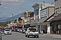
Olympic Avenue in downtown Arlington
-
Flag of Arlington, Washington
-
Seal of Arlington, Washington
-
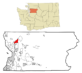
Location of Arlington within Snohomish County
-
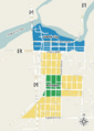
Map of original plats and claims for Arlington (green) and Haller City (blue), along with later additions to Arlington (yellow), overlaid on modern-day downtown Arlington
-
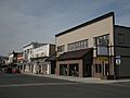
Storefronts on Olympic Avenue in downtown Arlington were built during the city's early history and have since been preserved
-
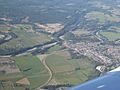
Aerial view of downtown Arlington and the Stillaguamish River floodplain
-
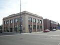
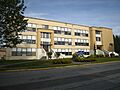
Arlington's city hall, located on Olympic Avenue in downtown
-
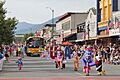
The 2025 Independence Day parade on Olympic Avenue
-
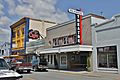
The Olympic Theatre in downtown Arlington, which operated as the city's lone movie theater from 1939 to 2014.
-
The former Arlington High School building, vacated in 2002
-
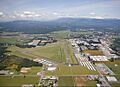
Aerial view of Arlington Municipal Airport


See also
 In Spanish: Arlington (Washington) para niños
