
Borders of Pakistan facts for kids

Pakistan is a country in South Asia. It shares its borders with several other countries. This makes Pakistan a special place, connecting different parts of Asia. The mighty Indus River is like its lifeline, providing water for the world's largest irrigation system.
Mountains like the Hindu Kush and Sulaiman Mountains are in the west. The Karakoram mountain range is in the north. The Thar Desert and Sutlej River are in the east. The Arabian Sea is to the south.
Pakistan was formed in 1947 when it became independent from the British Empire. Most people in Pakistan are Muslims.
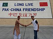
To the north, Pakistan borders China. This includes the Xinjiang region and the Tibet Autonomous Region. The disputed territory of Kashmir also borders China to the east. Pakistan shares its entire eastern border with Republic of India.
To the northwest, a narrow strip of land called the Wakhan Corridor separates Pakistan from Tajikistan. This corridor is controlled by Afghanistan. Afghanistan is to Pakistan's west and north. Iran (ancient Persia) is to the southwest. Pakistan also shares a sea border with Oman in the far southwest.
Pakistan covers about 982,413 square kilometers (379,309 square miles). This makes it larger than Tanzania but smaller than Egypt. It's also slightly smaller than France and Germany combined. If you compare it to US states, it's like Minnesota and Texas put together. If you add Kashmir, it's even bigger, like twice the size of California. Pakistan is potentially the eighth largest country in Asia and the thirtieth largest in the world. When it was formed in 1947, it was the tenth largest country.
Pakistan's Borders
Land Borders
Pakistan shares land borders with four countries. These borders are guarded by different forces to keep the country safe.
| Country | Length (kilometers) | Guarding Force | Notes |
|---|---|---|---|
| 2,080 km (1,292 mi) | Pakistan Army | This border is also known as the Durand Line. A barrier fence has been built along much of it. | |
| 524 km (326 mi) | Gilgit Baltistan Scouts and Northern Light Infantry | The border agreement with China might change if the Kashmir dispute is settled. | |
| 2,912 km (1,809 mi) | Pakistan Rangers and Pakistan Army | This is a long and important border. Parts of it are near the Rann of Kutch desert. | |
| 909 km (565 mi) | Pakistan Army | This border is generally open. | |
| 350 km (217 mi) | Pakistan Army and Gilgit Baltistan Scouts | Tajikistan claims a border with Pakistan through the Wakhan Corridor, which is controlled by Afghanistan. |
-
Monument on Khunjerab Pass, near the border with China.
-
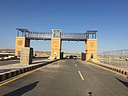
Border gate at Taftan, on the border with Iran.
-
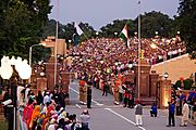
Evening flag lowering ceremony at the Wagah border, seen from the Pakistani side.
_near_Beautiful_Tunnels_at_atabad_lake_Hunza_Valley.jpg)


Sea Borders
Pakistan also has borders in the sea, known as maritime borders. These are recognized by international laws like the United Nations Convention on the Law of the Sea. These laws define areas like territorial waters (up to 12 nautical miles from the coast) and exclusive economic zones (up to 200 nautical miles), where a country has special rights.
Pakistan's coastline is 1,146 kilometers (712 miles) long. It shares sea borders with three nations. The sea border with India in the east is still being discussed. Pakistan and India have had many talks about the exact sea boundary near Kori Creek and the Rann of Kutch.
| Country | Guarding Force | Notes |
|---|---|---|
| Pakistan Navy and the Pakistan Coast Guard | The sea border near Kori Creek is still disputed. | |
| Pakistan Navy | This border is in the Sea of Oman. | |
| Pakistan Navy | This border is in the Arabian Sea. |
Images for kids
-
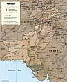
International and provincial boundaries of Pakistan.
-
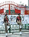
Women personnel of India's Border Security Force near the India-Pakistan border.
-
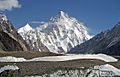
K2, at 8,619 meters (28,251 ft), is the world's second highest peak, located in the Karakoram mountain range.
-
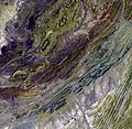
Satellite image of the Sulaiman Range.


