Bridgeville, New York facts for kids
Quick facts for kids
Bridgeville
|
|
|---|---|
|
hamlet and CDP
|
|
| Country | United States |
| State | New York |
| County | Sullivan |
| Time zone | UTC-5 (Eastern (EST)) |
| • Summer (DST) | UTC-4 (EDT) |
Bridgeville is a small community in New York. It is called a hamlet and also a census-designated place (CDP). You can find it southeast of Monticello, which is the main town for the county.
Bridgeville is nestled in the southern Catskill Mountains. It's part of the Town of Thompson in Sullivan County. The Neversink River flows through Bridgeville. It is also located along New York State Route 17, which will become Interstate 86 in the future. The area has many hills and sits about 1081 feet (330 meters) above sea level.
Since Bridgeville is a hamlet, it doesn't have its own post office. This means there are no official population numbers just for Bridgeville. It shares a ZIP code (12701) and telephone area code (845) with nearby Monticello.
Contents
Fun Things to Do in Bridgeville
Bridgeville is a great place for outdoor activities.
Fishing on the Neversink River
The Neversink River is very famous for fly-fishing. Many fishermen come to Bridgeville to enjoy this sport.
Skiing at Holiday Mountain
Bridgeville is also home to Holiday Mountain Ski Park. It's a popular spot for winter sports.
Bridgeville's Past: A Look at History
Bridgeville has a rich history, especially with its famous bridge.
Early Inhabitants
Long ago, Native American tribes lived in this area. These included members of the Algonquian and Lene Lenape (also known as Delaware) tribes.
New York's First Covered Bridge
Bridgeville was the site of the very first covered bridge in New York State. This important bridge was built in 1807. It helped with the construction of the Newburgh-Cochecton Turnpike. This turnpike was a major road that connected communities along the Delaware and Hudson rivers.
The turnpike helped open up new areas for settlement and trade. It also boosted the tanning industry. This industry made a lot of the leather used for boots by Union soldiers during the American Civil War.
The Bridge Today
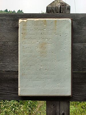
The original covered bridge was taken down in 1923. A new bridge (Sullivan County Bridge #285) was built in its place. This new bridge still crosses the Neversink River today. A marker on the original bridge shared details about its creation. It listed the architect, Maj. Salmon Wheat, and the company's directors.
Protecting History
In 1994, a court decision made sure that the old Hoyt Cemetery in Bridgeville would be properly cared for. This helped protect an important historical site.
Land Claims and Development
In the early 2000s, some Native American groups wanted to reclaim lands in the Bridgeville area. There were discussions about building a large casino near the Monticello Raceway. However, a decision by the United States Supreme Court in 2005 changed these plans. Many of the proposed land claims and casino projects were put on hold.
Water Monitoring in Bridgeville
Bridgeville plays a role in managing water resources.
Monitoring the Neversink River
Bridgeville is one of the places where "flow targets" are located. These are water meters used by the New York State Department of Environmental Conservation. They help monitor the fish habitat, water levels, and temperature below the Neversink Dam.
Drinking Water for Cities
The information from Bridgeville's meters is sent to the Delaware River Basin Commission. This data helps control how much water is released from the dam. This water is important for providing drinking water to large cities like New York City, Philadelphia, and Trenton. The Neversink River joins the upper Delaware River about 16 miles (26 kilometers) downstream from Bridgeville.
 | George Robert Carruthers |
 | Patricia Bath |
 | Jan Ernst Matzeliger |
 | Alexander Miles |


