
Brompton, London facts for kids
Quick facts for kids Brompton |
|
|---|---|
 Brompton Oratory (Church of the Immaculate Heart of Mary) |
|

Brompton
|
|
| Population | 8,839 (2011 Census.Ward) |
| OS grid reference | TQ274790 |
| London borough | |
| Ceremonial county | Greater London |
| Region | |
| Country | England |
| Sovereign state | United Kingdom |
| Post town | LONDON |
| Postcode district | SW3, SW5, SW7, SW10 |
| Dialling code | 020 |
| Police | Metropolitan |
| Fire | London |
| Ambulance | London |
| EU Parliament | London |
| UK Parliament | |
| London Assembly | |
Brompton, sometimes called Old Brompton, is a historic area in London, England. Today, its name mostly lives on as a special area called a "ward" within the Royal Borough of Kensington and Chelsea.
Long ago, in the 1800s, Brompton was a small village. It had many market gardens, which are farms that grow fruits and vegetables to sell. It was located in the county of Middlesex. Brompton was near other villages like Kensington and Knightsbridge. A main road, called the Fulham Turnpike, ran right through it. This road connected London to places like Fulham and Surrey.
Brompton got its first church, Holy Trinity Brompton, in 1829. Over time, the area changed a lot. New London Underground train lines were built, and stations like Knightsbridge, South Kensington, and Gloucester Road opened. These changes made Brompton feel less like a single village.
Many famous writers, actors, and thinkers have lived in Brompton. Its name is still used today for two local government areas: "Brompton" and "Hans Town".
Contents
What is Brompton?

The area known as Brompton Cross is where the old main road (Fulham Road) meets Thurloe Place and becomes Brompton Road. The original village of Brompton stretched along another road, which is now called Old Brompton Road.
Today, Old Brompton is centered around the South Kensington tube station and Gloucester Road tube station. It reaches all the way to West Brompton station. A historian named F.H.W. Sheppard explained that the main road was always busy. It connected London to many places. The name 'Brompton' used to refer more precisely to the settlement west of what is now South Kensington Station. This area was along a lane that led to Earl's Court.
This lane was called Brompton Lane or Bell and Horns Lane. It branched off the main road near an inn called the Bell and Horns. As more buildings went up closer to London, the original part of Brompton became known as Old Brompton. Brompton Lane became Old Brompton Road. This name is still used today, except for a short part near South Kensington Station, which is now Thurloe Place.
How Big Was Brompton?

Brompton's northern neighbors were Kensington Gore and Knightsbridge. Knightsbridge was a crossing over a hidden river called the Westbourne. Today, parts of old Brompton are considered part of "Knightsbridge" because of the tube network.
Brompton's borders were a bit uneven. This was because Kensington Gore had been part of Westminster for a long time. The Church of England has made things simpler now. A large church area, called Holy Trinity Brompton – St Paul's, Onslow Square and St Augustine's, Queen's Gate, covers a big part of what was once Brompton.
You can trace the old boundaries using today's streets. Starting from the north, they include:
- Imperial College Road
- Ennismore Street
- Montpellier Mews
- Knightsbridge (street)
- Basil Street
- Walton Street
- Fulham Road
- Drayton Gardens
- Ashburn, Grenville, Launceston, Kynance and Elvaston Places.
West Brompton became less important as Earls Court grew. But Brompton's old area was larger than these streets suggest. It had a long border along a hidden stream called Counter's Creek. This stream is now where the West London line railway runs. The border then went along Cromwell Road and Queen's Gate through Gloucester Road.
The areas of "South Kensington" and Kensington itself were to the north. Chelsea was to the south. Brompton's history is remembered mainly through its famous landmarks.
A Look Back in Time
_p1.360_-_Map_of_Middlesex.jpg)


The first time Brompton was mentioned in records was in 1292. It was a countryside area. Later, a main road, called a "turnpike road" (a road where you pay a toll to use it), was built. This road went from London through Brompton to Fulham and then over Putney Bridge into Surrey.
In 1681, four famous gardeners, including George London, started the Brompton Park Nurseries. These were large plant nurseries. A map from 1787 shows Brompton as mostly market gardens. About a hundred years later, in 1879, Charles Dickens Jr. wrote that Brompton was "almost exclusively the artists' quarter." This means many artists lived there.
Brompton got its first church, Holy Trinity Brompton, in 1829. This quickly led to it becoming its own church parish.
Brompton started to change and become less distinct due to two main reasons. First, the Great Exhibition of 1851 brought many people and new buildings to the area. Museums and colleges were built. Second, railways arrived. The train station built in 1868 to serve the crowds was named South Kensington, not "Brompton."
A "Brompton Road station" opened in 1906 but closed in 1934 because not enough people used it. Gloucester Road tube station, which opened in 1868, was first called "Gloucester Road, Brompton." But the "Brompton" part was later dropped to make it simpler. Because of these changes, Brompton stopped being a main place or destination.
In 1965, the old areas of Kensington and Chelsea joined together. They formed one new authority. A new symbol, called a "coat of arms," was created for it. This symbol included a broom bush. This represents the link to 'Brompton' because the name Brompton comes from 'broom tun,' meaning a gorse farm. In medieval times, Brompton was known for its gorse fields.
Today, the Royal Borough of Kensington and Chelsea has a "Brompton Conservation Area." This is a small part of the historic village of Brompton. The rest of the old village is now part of other nearby conservation areas.
Famous Places in Brompton
Brompton is home to many important and interesting places. Here are some of them:
- Bolton's Theatre Club
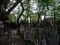
- Brompton Cemetery
- Brompton Oratory (a beautiful church)
- Chelsea and Westminster Hospital
- Church of St Yeghiche (an Armenian cathedral)
- Deutsche Evangelische Christuskirche (a German church)
- Fulham Road Jewish Cemetery
- Gloucester Road tube station
- Goethe-Institut (a German cultural institute)
- Holy Trinity Brompton
- Imperial College London (a famous university)
- French Institute
- Ishmaili Centre
- Lycée Français Charles de Gaulle (a French school)
- Michelin House (a historic building)
- Natural History Museum
- Royal Brompton Hospital
- Royal Marsden Hospital
- Royal Society of Sculptors
- Science Museum
- South Kensington tube station
- Victoria and Albert Museum (a large museum of art and design)
- West Brompton station
Important Streets of Brompton
Many streets in Brompton have their own history and character. Some of the notable ones include:
- Beauchamp Place
- The Boltons
- Brompton Place
- Brompton Road
- Brompton Square
- Cranley Gardens
- Cromwell Road
- Drayton Gardens
- Egerton Gardens
- Exhibition Road
- Fulham Road
- Gloucester Road
- Hereford Square
- Lennox Gardens
- Old Brompton Road
- Onslow Square
- Ovington Square
- Pont Street
- Prince Consort Road
- Queen's Gate
- Thurloe Square
- Walton Street
Nearby Areas
The names Brompton and Old Brompton are not commonly used by the Tube or postal service anymore. Instead, different parts of Brompton are now known by other names:
- The eastern part is often called Knightsbridge.
- The central part is called South Kensington.
- The southern part is called Gloucester Road or sometimes Chelsea.

Here are some places close to Brompton:
- Belgravia
- Brompton Cemetery
- Chelsea Physic Garden
- Royal Hospital Chelsea
- Earl's Court
- Fulham Broadway
- Hyde Park
- Kensington Gardens
- Kensington
- Little Chelsea
- Sloane Square
- West Brompton
Famous People from Brompton

Many interesting people have lived in or been connected to Brompton:
- Muzio Clementi (1752–1832), an Italian-born composer and pianist.
- William Wilberforce (1759–1833), an English politician who worked to end slavery.
- George Canning (1770–1827), a British politician.
- Caroline Clive (1801–1873), an English writer.
- Henry Cole (1808–1882), a civil servant and inventor who helped start the idea of the Christmas card.
- Jenny Lind (1820–1887), a famous Swedish opera singer.
- W. S. Gilbert (1836–1911), a playwright and lyricist, known for his work with Arthur Sullivan.
- Stéphane Mallarmé (1842–1898), a French poet.
- Edwin Lutyens (1869–1944), a famous Anglo-Irish architect.
- Agatha Christie (1890–1976), a world-famous English crime writer.
- Mervyn Peake (1911–1968), an English writer, poet, and illustrator.
- Rosalind Franklin (1920–1958), a British chemist who made important discoveries about the structure of DNA.
Images for kids
-
Brompton on William Faden's 1790 map
-
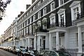
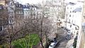
Onslow Square, London SW7, with buildings typical of today's "Brompton"
-
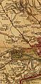
Pigot & Co. (1842) map showing Brompton in the County of Middlesex
-
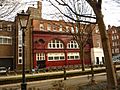
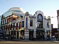
206 Brompton Road, a former station building
-
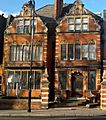
Royal Society of British Sculptors at 108 Old Brompton Road
-
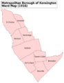
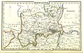
The southeast corner of this map shows the Brompton ward of Kensington Metropolitan Borough in 1916. Old Brompton was to the southwest. Old Brompton Road connected both areas to the northwest.
-
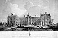
The first Brompton Hospital on the Fulham Road, around 1850
-
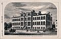
Brompton Cancer Hospital in 1859, Kensington, London
-
Brompton Square, London
-
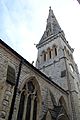
St Yeghiche Armenian cathedral, London SW7
-
Michelin House, Brompton
-
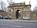
Brompton Cemetery North Gate on Old Brompton Road
-
Jewish Cemetery, Fulham Road, Brompton
