Brugg District facts for kids
Quick facts for kids
Brugg District
Bezirk Brugg
|
|
|---|---|
|
District
|
|
| Country | |
| Canton | |
| Capital | Brugg |
| Area | |
| • Total | 130.08 km2 (50.22 sq mi) |
| Population
(2020)
|
|
| • Total | 52,042 |
| • Density | 400.077/km2 (1,036.19/sq mi) |
| Time zone | UTC+1 (CET) |
| • Summer (DST) | UTC+2 (CEST) |
| Municipalities | 20 |
The Brugg District is a part of Aargau, a canton in Switzerland. The main town, or capital, of this district is Brugg.
Contents
About Brugg District
What is Brugg District Like?
The Brugg District covers about 149 square kilometers. A large part of the land is used for farming, about 42.6%. Forests cover another big part, around 41.3%. The remaining 14.1% of the land is where people live and build things.
The district is located near two important rivers: the Aare and the Reuss. The northern part of the district, which is north of the Aare river, is in the Jura mountains.
How Many People Live Here?
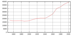
As of June 2009, the Brugg District had a population of 46,471 people.
In 2000, there were many different types of homes. About 1,635 homes had only one or two people living in them. Most homes, around 8,736, had three or four people. There were also 6,792 homes with five or more people. On average, each home had about 2.41 people.
In 2008, there were 20,725 homes and apartments in total. About 7,550 of these were single-family homes. This means about 36.4% of all homes were for one family. Only a small number of apartments, 194, were empty, which is a very low vacancy rate of 0.9%.
Education in Brugg District
In the 2008/2009 school year, many students attended schools in the district.
- About 3,374 students went to primary school.
- Around 1,246 students attended secondary school.
- There were 780 students studying at university or college level.
How Do People Work Here?
In 2000, about 22,875 people who lived in the Brugg District also worked there. However, 17,446 residents worked outside the district. Also, 14,574 people traveled into the district for their jobs. This shows that many people commute for work.
What Religions Are Practiced?
Based on the 2000 census, people in the Brugg District follow different religions:
- About 13,426 people, or 30.4%, were Roman Catholic.
- A larger group, 20,463 people or 46.4%, belonged to the Swiss Reformed Church.
- A small number of people, 72 individuals, were part of the Christian Catholic faith.
Towns and Villages
The Brugg District is made up of several towns and villages, which are called municipalities. Here is a list of them:
| Coat of arms | Municipality | Population 2020 |
Area (km²) |
|---|---|---|---|
| Auenstein | 1,613 | 5.68 | |
| Birr | 4,598 | 5.05 | |
| Birrhard | 742 | 3 | |
| Bözberg | 1,663 | 15.5 | |
| Brugg | 12,738 | 8.26 | |
| Habsburg | 428 | 2.23 | |
| Hausen bei Brugg | 3,734 | 3.2 | |
| Lupfig | 12,679 | 5.15 | |
| Mandach | 325 | 5.54 | |
| Mönthal | 393 | 3.94 | |
| Mülligen | 1,074 | 3.16 | |
| Remigen | 1,326 | 7.87 | |
| Riniken | 1,482 | 4.76 | |
| Rüfenach | 863 | 4.17 | |
| Schinznach | 2,319 | 12.24 | |
| Thalheim | 820 | 9.92 | |
| Veltheim | 1,526 | 5.24 | |
| Villigen | 2,120 | 11.21 | |
| Villnachern | 1,654 | 5.75 | |
| Windisch | 7,733 | 4.91 | |
| Total | 52,042 | 130.08 |
Changes to Municipalities
Over the years, some of the smaller towns and villages in the district have joined together to form larger ones. This helps with managing the areas better. Here are some of these changes:
- In 2006, the village of Stilli became part of Villigen.
- On January 1, 2010, Umiken joined with Brugg. Also, Hottwil from Brugg district merged with other villages from the Laufenburg district to create a new municipality called Mettauertal. This meant Hottwil moved to the Laufenburg district.
- On January 1, 2013, four villages – Gallenkirch, Linn, Oberbözberg, and Unterbözberg – combined to form the new municipality of Bözberg.
- In 2014, Oberflachs and Schinznach-Dorf merged to create Schinznach.
- On January 1, 2018, Scherz merged into Lupfig.
- On January 1, 2020, Schinznach-Bad merged into Brugg.
- On January 1, 2022, Bözen, Effingen, and Elfingen from Brugg district, along with Hornussen from Laufenburg district, merged to form the new municipality of Böztal.
See also
 In Spanish: Distrito de Brugg para niños
 | Laphonza Butler |
 | Daisy Bates |
 | Elizabeth Piper Ensley |


