Caldwell County, Missouri facts for kids
Quick facts for kids
Caldwell County
|
|
|---|---|

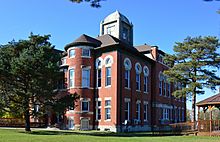
Caldwell County courthouse in Kingston
|
|

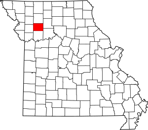
Location within the U.S. state of Missouri
|
|
 Missouri's location within the U.S. |
|
| Country | |
| State | |
| Founded | December 29, 1836 |
| Named for | John Caldwell |
| Seat | Kingston |
| Largest city | Hamilton |
| Area | |
| • Total | 430 sq mi (1,100 km2) |
| • Land | 426 sq mi (1,100 km2) |
| • Water | 3.2 sq mi (8 km2) 0.8% |
| Population
(2020)
|
|
| • Total | 8,815 |
| • Density | 20.50/sq mi (7.92/km2) |
| Time zone | UTC−6 (Central) |
| • Summer (DST) | UTC−5 (CDT) |
| Congressional district | 6th |
Caldwell County is a county in Missouri, United States. As of the 2020 census, about 8,815 people live there. It is part of the larger Kansas City metropolitan area. The main town and county seat is Kingston.
The county was created on December 29, 1836. It was named by Alexander Doniphan to honor John Caldwell. John Caldwell was an important person in Kentucky. He was the second Lieutenant Governor of Kentucky.
Caldwell County was first set up as a safe place for Mormons. They had been forced to leave Jackson County in 1833. They then found safety in nearby Clay County. The county was a key location during the 1838 Missouri Mormon War. This conflict led to all Latter Day Saints leaving Missouri. This happened after the Governor, Lilburn Boggs, issued a special order.
Contents
History of Caldwell County
Early Mormon Settlement
Caldwell County was originally part of Ray County. The first European settler was Jesse Mann Sr. He settled near Kingston in 1831. However, early settlers moved south in 1832 for safety. This was during the Black Hawk War uprising.
A few Mormon settlers moved into the county in 1832. They had been forced out of Jackson County, Missouri. One of these settlers was Jacob Hawn. His mill on Shoal Creek later became the site of a sad event. This event was known as the Hawn's Mill Massacre.
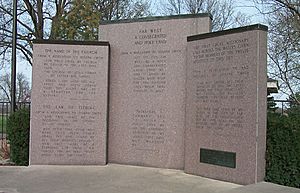
The settlers created Salem, the county's first town. It was two miles southeast of Kingston. Many more Mormons moved to the county in the fall of 1836. The Missouri government created Caldwell County in December 1836. It was understood that this county would be for Mormon settlers. Its first county seat was Far West, Missouri. By 1838, Far West had about 4,000 people.
Many important early Mormon leaders moved here. These included Joseph Smith, Hyrum Smith, and Brigham Young. Others were John Taylor, Edward Partridge, and Sidney Rigdon. Also, Parley P. Pratt and John D. Lee were part of this move.
The Mormon War
Mormon settlers later moved north into Daviess County. A key place was Adam-ondi-Ahman. Joseph Smith said this was a special biblical place. He believed it would be a gathering spot on the Judgement Day.
The Mormon War began after a fight. It was between original Missouri settlers and Mormon settlers. This happened during the Gallatin Election Day Battle. After a battle at Crooked Creek, the Missouri militia was defeated.
Then, Governor Lilburn Boggs issued an order. This order was to make the Mormons leave the state. Three days later, a group from Livingston County killed 18 Mormons. This happened at the Hawn's Mill massacre.
Troops surrounded Far West. Joseph Smith surrendered in October 1838. The Mormon settlers agreed to leave. They left Far West and first gathered in Quincy, Illinois. This was during the winter of 1838–39. The next spring, they started a new city called Nauvoo, Illinois. After Far West was no longer the county seat, Kingston became the main town.
Geography of Caldwell County
The county covers about 430 square miles. Most of this area, 426 square miles, is land. About 3.2 square miles, or 0.8%, is water.
Neighboring Counties
- Daviess County (north)
- Livingston County (east)
- Carroll County (southeast)
- Ray County (south)
- Clinton County (west)
- DeKalb County (northwest)
Main Roads
People of Caldwell County (Demographics)
| Historical population | |||
|---|---|---|---|
| Census | Pop. | %± | |
| 1840 | 1,458 | — | |
| 1850 | 2,310 | 58.4% | |
| 1860 | 5,034 | 117.9% | |
| 1870 | 11,390 | 126.3% | |
| 1880 | 13,646 | 19.8% | |
| 1890 | 15,152 | 11.0% | |
| 1900 | 16,656 | 9.9% | |
| 1910 | 14,605 | −12.3% | |
| 1920 | 13,849 | −5.2% | |
| 1930 | 12,509 | −9.7% | |
| 1940 | 11,629 | −7.0% | |
| 1950 | 9,929 | −14.6% | |
| 1960 | 8,830 | −11.1% | |
| 1970 | 8,351 | −5.4% | |
| 1980 | 8,660 | 3.7% | |
| 1990 | 8,380 | −3.2% | |
| 2000 | 8,969 | 7.0% | |
| 2010 | 9,424 | 5.1% | |
| 2020 | 8,815 | −6.5% | |
| U.S. Decennial Census 1790-1960 1900-1990 1990-2000 2010-2015 |
|||
In 2000, there were 8,969 people living in the county. There were 3,523 households and 2,501 families. The population density was about 8 people per square mile. Most people (98.56%) were White.
About 32.30% of households had children under 18. Most households (59.20%) were married couples. The average household had 2.51 people. The average family had 3.04 people.
The median age in the county was 39 years old. About 27.10% of the population was under 18. About 17.00% were 65 or older. For every 100 females, there were about 97.60 males.
The median income for a household was $31,240. For a family, it was $37,087. About 11.90% of the population lived below the poverty line. This included 15.10% of those under 18.
2020 Census Information
| Race | Number | Percent |
|---|---|---|
| White (Not Hispanic) | 8,172 | 93% |
| Black or African American (Not Hispanic) | 65 | 1% |
| Native American (Not Hispanic) | 34 | 0.4% |
| Asian (Not Hispanic) | 26 | 0.3% |
| Pacific Islander (Not Hispanic) | 7 | 0.08% |
| Other/Mixed (Not Hispanic) | 360 | 4.1% |
| Hispanic or Latino | 151 | 1.7% |
Education in Caldwell County
Public Schools
- Braymer C-4 School District – Braymer
- Braymer Elementary School (Grades PK-6)
- Braymer High School (Grades 7-12)
- Breckenridge R-I School District – Breckenridge
- Breckinridge Elementary School (Grades PK-6)
- Breckinridge High School (Grades 7-12)
- Cowgill R-VI School District – Cowgill
- Cowgill Elementary School (Grades PK-8)
- Kingston School District No. 42 – Kingston
- Kingston Elementary School (Grades PK-8)
- Mirabile C-1 School District – Polo
- Mirabile Elementary School (Grades PK-8)
- New York R-IV School District – Hamilton
- New York Elementary School (Grades K-8)
- Polo R-VII School District – Polo
- Polo Elementary School (Grades PK-4)
- Polo Middle School (Grades 5-8)
- Polo High School (Grades 9-12)
- Hamilton R-2 School District - Hamilton, Missouri
Public Libraries
- Breckenridge Public Library
- Hamilton Public Library
Communities in Caldwell County
Cities
Ghost Town
Townships
Caldwell County is divided into 12 townships:
- Breckenridge
- Davis
- Fairview
- Gomer
- Grant
- Hamilton
- Kidder
- Kingston
- Lincoln
- Mirabile
- New York
- Rockford
Unincorporated Communities
Famous People from Caldwell County
- Colin Brown, a former NFL football player.
- Herb Conyers, a former professional baseball player.
- Jenny Doan, a famous quilter.
- Charles J. Hughes Jr., a former U.S. Senator from Colorado.
- James Kirkpatrick, a former Missouri Secretary of State.
- Frank B. Klepper, a former U.S. Representative from Missouri.
- Glen Lukens, a well-known ceramics artist.
- James Cash Penney, the person who started JC Penney stores.
- Mack Wheat, a Major League Baseball player.
- Zack Wheat, a Major League Baseball player.
See also
 In Spanish: Condado de Caldwell (Misuri) para niños
 | Frances Mary Albrier |
 | Whitney Young |
 | Muhammad Ali |


