Calhoun County, Florida facts for kids
Quick facts for kids
Calhoun County
|
|
|---|---|

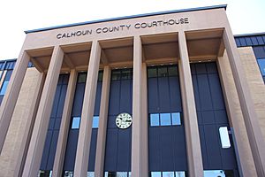
Calhoun County Courthouse in Blountstown
|
|

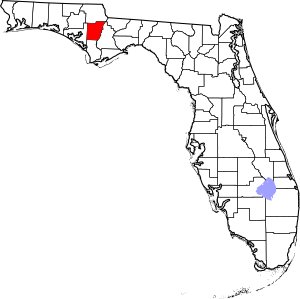
Location within the U.S. state of Florida
|
|
 Florida's location within the U.S. |
|
| Country | |
| State | |
| Founded | January 26, 1838 |
| Named for | John C. Calhoun |
| Seat | Blountstown |
| Largest city | Blountstown |
| Area | |
| • Total | 574 sq mi (1,490 km2) |
| • Land | 567 sq mi (1,470 km2) |
| • Water | 7.0 sq mi (18 km2) 1.22 %% |
| Population
(2020)
|
|
| • Total | 13,648 |
| • Density | 25.5/sq mi (9.8/km2) |
| Time zone | UTC−6 (Central) |
| • Summer (DST) | UTC−5 (CDT) |
| Congressional district | 2nd |
Calhoun County is a quiet county in the northern part of Florida. It is a rural area, meaning it has many open spaces and smaller towns. In 2020, about 13,648 people lived there. This makes it one of the least populated counties in Florida. The main town and county seat is Blountstown.
Contents
History of Calhoun County
Calhoun County was created in 1838. It was named after John C. Calhoun. He was a very important person in U.S. history. He served as a Senator for South Carolina. He was also the seventh U.S. Vice President. He worked with Presidents John Quincy Adams and Andrew Jackson.
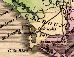
The county was first located near St. Joseph Bay and the Apalachicola River. The first county seat was St. Joseph. However, this town was later abandoned by 1844. This happened because of a serious illness and strong hurricanes.
In the late 1850s, there were some serious conflicts in the county. These disagreements led to a time of trouble. The county judge even had to ask for help from the Florida Militia. About 150 soldiers came to help bring peace back to the area.
During the American Civil War, some groups in the countryside avoided joining the army. These groups were in touch with the Union forces. They even planned to capture the Confederate Governor Milton. But Governor Milton found out about the plan and escaped.
Later, Calhoun County grew bigger. It gained land from Jackson and Washington counties. In 1913, some land was given to the new Bay County. Then, in 1925, the southern part of Calhoun County became the new Gulf County. This new county included the area where Calhoun County first started.
Geography and Nature
Calhoun County covers about 574 square miles. Most of this is land, with about 7 square miles of water. The Apalachicola River forms the eastern border of the county. The Chipola River flows right through the middle of the county. This river is home to a special place called Look and Tremble.
Towns and Communities
Calhoun County has two main towns:
There are also many smaller, unincorporated communities. These are places that don't have their own local government. Some of these include Broad Branch, Chipola, Clarksville, and Kinard.
Neighboring Counties
Calhoun County shares its borders with several other counties:
- Jackson County, Florida to the north
- Gadsden County, Florida to the northeast
- Liberty County, Florida to the east
- Gulf County, Florida to the south
- Bay County, Florida to the west
People of Calhoun County
| Historical population | |||
|---|---|---|---|
| Census | Pop. | %± | |
| 1840 | 1,142 | — | |
| 1850 | 1,377 | 20.6% | |
| 1860 | 1,446 | 5.0% | |
| 1870 | 998 | −31.0% | |
| 1880 | 1,580 | 58.3% | |
| 1890 | 1,681 | 6.4% | |
| 1900 | 5,132 | 205.3% | |
| 1910 | 7,465 | 45.5% | |
| 1920 | 8,775 | 17.5% | |
| 1930 | 7,298 | −16.8% | |
| 1940 | 8,218 | 12.6% | |
| 1950 | 7,922 | −3.6% | |
| 1960 | 7,422 | −6.3% | |
| 1970 | 7,624 | 2.7% | |
| 1980 | 9,294 | 21.9% | |
| 1990 | 11,011 | 18.5% | |
| 2000 | 13,017 | 18.2% | |
| 2010 | 14,625 | 12.4% | |
| 2020 | 13,648 | −6.7% | |
| 2023 (est.) | 13,470 | −7.9% | |
| U.S. Decennial Census 1790–1960 1900–1990 1990–2000 2010–2015 2020 |
|||
In 2020, the census showed that 13,648 people lived in Calhoun County. There were 4,510 households. About 2,753 families lived there. The population is made up of different groups. Most people are White. There are also many Black or African American residents. Other groups include Native American, Asian, and people of mixed races. About 4.56% of the population is Hispanic or Latino.
Getting Around Calhoun County
Calhoun County does not have any major Interstate or U.S. Highways. The closest Interstate highway is Interstate 10. You can find it in Sneads in nearby Jackson County. The closest U.S. Highway is U.S. Route 231. It is in northeastern Bay County.
Main Roads
Several state roads help people travel through Calhoun County:
 FL 20 is a main road that goes east and west. It connects Niceville to Tallahassee, the state capital.
 FL 69 starts in Blountstown.
 FL 71 is a main road that goes north and south. It links Port St. Joe to Alabama.
 FL 73 begins in the southern part of Calhoun County.
Airport
Calhoun County has its own airport. It is called the Calhoun County Airport (Florida).
Education and Libraries
Schools
The Calhoun County School District runs the public schools. There are two high schools in the county. They are Blountstown High School and Altha Public School.
Libraries
Calhoun County has a public library system. It has six branches. The county is also part of the Panhandle Public Library Cooperative System. This system also includes libraries in Holmes and Jackson counties. Libraries offer computers with internet, free Wi-Fi, and programs for all ages. You can also find e-books and online resources.
The library branches are in these communities:
- Blountstown Public Library
- Altha Public Library
- Hugh Creek Public Library
- Kinard Public Library
- Mossy Pond Public Library
- Shelton Public Library
See also
 In Spanish: Condado de Calhoun (Florida) para niños
 | Aaron Henry |
 | T. R. M. Howard |
 | Jesse Jackson |


