
Campbell Island, New Zealand facts for kids

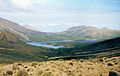
Six Foot Lake, on Campbell Island / Motu Ihupuku
|
|

Map of Campbell Island / Motu Ihupuku
|
|

Campbell Island / Motu Ihupuku
Location in Pacific Ocean
|
|
| Etymology | Robert Campbell |
|---|---|
| Geography | |
| Location | Pacific Ocean |
| Coordinates | 52°32′24″S 169°8′42″E / 52.54000°S 169.14500°E |
| Archipelago | Campbell Islands |
| Area | 112.68 km2 (43.51 sq mi) |
| Highest elevation | 569 m (1,867 ft) |
| Highest point | Mount Honey |
| Administration | |
|
New Zealand
|
|
| Demographics | |
| Population | 0 |
| Additional information | |
| Time zone |
|
| • Summer (DST) |
|
| UN/LOCODE: TF | |
Campbell Island / Motu Ihupuku is an island that has no people living on it. It is part of New Zealand and is located in the subantarctic area. It is the main island of the Campbell Island group. The island is about 112.68 square kilometers (43.51 sq mi) in size. It is surrounded by many small islands and rocks. Some of these are Dent Island and Jacquemart Island. Jacquemart Island is the very southernmost point of New Zealand.
The island is very mountainous, with peaks rising over 500 meters (1,600 ft) high in the south. A long, narrow bay called a fiord, named Perseverance Harbour, almost cuts the island in half. This bay opens up to the sea on the east side. Campbell Island is a special place. It is listed as a UNESCO World Heritage Site.
Contents
History of Campbell Island

Campbell Island was found in 1810 by Captain Frederick Hasselborough. He was on a ship called the Perseverance. This ship was used for hunting seals. The ship's owner was Robert Campbell, and the island was named after him. Sadly, Captain Hasselborough drowned in Perseverance Harbour on November 4, 1810. A young woman and a boy also drowned with him.
The island became a base for hunting seals. So many seals were hunted that almost none were left. The first big period of seal hunting ended around 1815. There was a short return to hunting in the 1820s. Seal hunting happened from 1810 until 1912. During this time, 49 ships visited the island for sealing.
Whaling also became popular here in the 1830s and 1840s. In 1874, a group of French scientists visited the island. They came to watch the planet Venus pass in front of the sun. Many places on the island are named after people or things from this trip.

In December 1840, Campbell Island was the last land seen by the Ross expedition. This group was on their way to explore the Antarctic.
In 1883, an American whaling ship called the Sarah W. Hunt was near Campbell Island. Twelve men went to the island in two small boats to look for seals. The weather was very bad. One boat disappeared. The other boat, with six men, made it to shore. The captain of the Sarah W. Hunt thought all the whalers were lost. He sailed away to Lyttelton, New Zealand. Luckily, a boat that protected seals, the Kekeno, arrived at the island. It rescued the stranded men. The captain's actions caused a big problem between countries.
In the late 1800s, people started raising sheep on the island. This continued from 1896 until 1931. The sheep farm was left empty because of the Great Depression.
In 1907, a group of scientists spent eight days on the island. They studied the island's magnetic field. They also collected plants, animals, and rocks.
During World War II, a station was set up at Tucker Cove. People there watched the coast as part of the Cape Expedition program.
In 1992, a picture of Campbell Island was put on the back of the New Zealand five-dollar note. It shows a yellow-eyed penguin, a subantarctic lily, a daisy, and bull kelp.
In 1998, the island's name was officially changed to Campbell Island / Motu Ihupuku. This happened after a special agreement with the Ngāi Tahu people.
In 2012, a group of amateur radio operators visited Campbell Island. They made over 42,000 radio contacts with people around the world.
Weather Station on Campbell Island
| Campbell Island Automatic Weather Station | |
|---|---|

Meteorological station at Beeman Cove (unmanned/automatic since 1995)
|
|
| General information | |
| Type | Automatic weather station |
| Coordinates | 52°33′04″S 169°09′04″E / 52.550973°S 169.150981°E |
| Opened | 1946 |
| Owner | MetService |
After World War II, the coast-watching station was changed into a weather station. This was used until 1958. Then, a new base was built at Beeman Cove. This new place was better for weather instruments. It also had modern living spaces for up to 12 staff.
The new weather station was run by the New Zealand Meteorological Service. Ten staff members lived on the island for 12-month periods. They reported the weather every three hours. They also launched balloons twice a day to measure the upper air. These weather reports were sent to New Zealand by radio.
Besides weather, the staff also studied earthquakes. They measured the Earth's magnetic field and the aurora australis (southern lights). They also tagged Albatross birds and counted Southern Right Whales.
In April 1992, a staff member named Mike Fraser was attacked by a great white shark. This happened while he was swimming at Northwest Bay. He was about 30 meters (98 ft) from the beach. Mike was badly hurt on both arms. His teammate, Jacinda Amey, helped him get back to shore. The team kept him alive while a rescue helicopter came from Taupō. This was the longest single-engine helicopter rescue ever.
Jacinda Amey received the New Zealand Cross. This is the highest bravery award for civilians. The helicopter pilot, John Funnell, received the New Zealand Bravery Medal.
In 1995, the staff were removed from the station. An automatic weather station took over their work. Today, staff from the Meteorological Service visit the island. They maintain the weather station and help conservation staff. Sometimes, eco-tourism cruises also visit the island in summer.
In May 2018, scientists recorded a huge wave near the island. It was 23.8 meters (78 ft) tall. They believe it was the largest wave ever recorded in the Southern Hemisphere at that time.
The Legend of The Lady of the Heather
The Lady of the Heather is a romantic book from 1945 by Will Lawson. The story mixes facts and made-up events. It is about Captain Hasselborough's death on Campbell Island. The book tells of a daughter of Bonnie Prince Charlie. She is sent to Campbell Island because people thought she betrayed the Jacobite cause.
Her character was inspired by Elizabeth Farr. She was likely a "ship girl" who traveled with sailors. Her presence and death in this faraway place led to the story of The Lady of the Heather.
Climate of Campbell Island
Campbell Island has a cold, windy climate called a maritime tundra climate. The island gets only about 647 hours of sunshine each year. This means it has less than an hour of sun on 215 days (59%) of the year. Clouds often cover the island's peaks.
It rains a lot, about 1329 millimeters (52.3 in) each year. Rain, mostly light showers or drizzle, falls on about 325 days a year. It often snows in winter and spring. The island is very windy. Gusts of over 96 kilometers per hour (60 mph) happen on at least 100 days every year.
Temperatures do not change much. The average yearly temperature is 7°C (45°F). It rarely gets warmer than 12.1°C (53.8°F). The warmest temperature ever recorded was 21.2°C (70.2°F). The coldest was -7.9°C (17.8°F).
| Climate data for Campbell Island (1991–2020 normals) | |||||||||||||
|---|---|---|---|---|---|---|---|---|---|---|---|---|---|
| Month | Jan | Feb | Mar | Apr | May | Jun | Jul | Aug | Sep | Oct | Nov | Dec | Year |
| Record high °C (°F) | 21.2 (70.2) |
19.3 (66.7) |
16.1 (61.0) |
15.8 (60.4) |
12.4 (54.3) |
11.3 (52.3) |
10.3 (50.5) |
10.4 (50.7) |
12.7 (54.9) |
15.4 (59.7) |
18.3 (64.9) |
20.0 (68.0) |
21.2 (70.2) |
| Mean daily maximum °C (°F) | 12.0 (53.6) |
11.8 (53.2) |
10.9 (51.6) |
9.6 (49.3) |
8.4 (47.1) |
7.1 (44.8) |
7.0 (44.6) |
7.4 (45.3) |
7.9 (46.2) |
8.8 (47.8) |
9.8 (49.6) |
11.5 (52.7) |
9.4 (48.9) |
| Daily mean °C (°F) | 9.6 (49.3) |
9.5 (49.1) |
8.8 (47.8) |
7.7 (45.9) |
6.5 (43.7) |
5.0 (41.0) |
5.1 (41.2) |
5.3 (41.5) |
5.7 (42.3) |
6.3 (43.3) |
7.2 (45.0) |
8.9 (48.0) |
7.1 (44.8) |
| Mean daily minimum °C (°F) | 7.2 (45.0) |
7.2 (45.0) |
6.7 (44.1) |
5.7 (42.3) |
4.5 (40.1) |
3.0 (37.4) |
3.2 (37.8) |
3.2 (37.8) |
3.6 (38.5) |
3.9 (39.0) |
4.7 (40.5) |
6.4 (43.5) |
4.9 (40.8) |
| Record low °C (°F) | 2.9 (37.2) |
2.3 (36.1) |
0.5 (32.9) |
0.0 (32.0) |
−3.2 (26.2) |
−6.5 (20.3) |
−7.9 (17.8) |
−6.4 (20.5) |
−4.2 (24.4) |
−1.4 (29.5) |
−1.2 (29.8) |
3.2 (37.8) |
−7.9 (17.8) |
| Average precipitation mm (inches) | 124.7 (4.91) |
102.2 (4.02) |
124.1 (4.89) |
121.1 (4.77) |
133.6 (5.26) |
113.6 (4.47) |
115.0 (4.53) |
108.1 (4.26) |
112.9 (4.44) |
114.3 (4.50) |
118.1 (4.65) |
114.6 (4.51) |
1,402.3 (55.21) |
| Average precipitation days (≥ 1.0 mm) | 18.8 | 17.5 | 20.3 | 19.3 | 22.6 | 22.2 | 22.8 | 21.6 | 20.6 | 22.2 | 19.6 | 18.5 | 246.2 |
| Mean monthly sunshine hours | 74.8 | 72.4 | 66.4 | 48.6 | 39.4 | 29.2 | 31.3 | 34.5 | 52.2 | 63.4 | 62.9 | 72.2 | 647.3 |
| Source 1: NOAA | |||||||||||||
| Source 2: NIWA National Climate Database (sunshine and extremes) | |||||||||||||
Plants and Animals
Important Bird Area
Campbell Island is a very important place for birds. It is the main breeding area for the southern royal albatross. The island group is an Important Bird Area (IBA). This means it is special for many seabirds. It is also home to the Campbell teal and Campbell snipe, which are found nowhere else.
Many types of penguins also live and breed here. These include the yellow-eyed penguin, the rockhopper penguin, and the erect-crested penguin. Other albatross species breed on the island too. These are the Campbell black-browed albatross, Antipodean albatross, light-mantled sooty albatross, Black-browed mollymawk and the grey-headed mollymawk.
Other birds that breed on the island include the sooty shearwater, the grey petrel, and the white-chinned petrel. The Campbell Island shag is also unique to the island. You can also find the grey duck, the southern skua, and different types of gulls and terns. Many smaller birds like the song thrush, Common blackbird, and New Zealand pipit also live here.
The World's Most Remote Tree
Campbell Island has what people believe is the world's most remote tree. It is a single Sitka spruce tree, over 100 years old. The closest other tree is more than 222 kilometers (138 mi) away on the Auckland Islands. This tree was likely planted by Lord Ranfurly between 1901 and 1907. Some scientists think this tree could be a marker for the start of the anthropocene epoch. This is a new period in Earth's history where humans have greatly changed the planet.
Conservation Efforts
In 1954, the island became a nature reserve. Wild Campbell Island cattle were removed by 1984. Wild Campbell Island sheep were also removed between the 1970s and 1992. In 2001, brown rats (Norway rats) were completely removed from the island. They had been there for almost 200 years. This was the largest rat removal project in the world.
The island was confirmed to be rat-free in 2003. Since then, plants and small animals have been growing back. Seabirds are returning. The Campbell teal, the rarest duck in the world, has been brought back to the island. A new type of parakeet was found in fossil bones in 2004. There was also evidence of a falcon or harrier.
The Campbell snipe is a special type of bird found only here. It was discovered in 1997 on a tiny island called Jacquemart Island. This island was free of rats. After the rats were removed from the main island, the snipe started to move back there.
Marine mammals are also recovering. Sea lions and southern elephant seals are starting to live on the island again. Some southern right whales still come into the bays in winter to have their babies. This is especially true at Northwest Bay and Perseverance Harbour.
Campbell Island is one of five subantarctic island groups. All of them are recognized as a World Heritage Site by UNESCO.
Geology of Campbell Island
Campbell Island is an old shield volcano that is no longer active. Over time, the ocean has worn it down into its current shape. The volcano has been inactive for about six million years. Ice covered the island until about 15,000 years ago, stopping plants from growing. The main rocks on Campbell Island are basalt and trachyte. These rocks formed between 6.5 and 11 million years ago. The island is part of a large, mostly underwater continent called Zealandia.
Research on the Island
During World War II, the New Zealand government had people watching the coast on the island. These people were also naturalists. They studied the island's rocks, plants, and animals.
To celebrate 200 years since its discovery, a big research trip happened. It was called the Campbell Island Bicentennial Expedition (CIBE). This trip took place from December 2010 to February 2011. It was the largest research trip to the island in over 20 years. The goal was to learn about the island's human history. They also wanted to see how plants and small animals were recovering. This was after the sheep were removed and the rats were taken away. Scientists also studied the island's streams and the creatures living in them. They looked at lake sediments to understand past climate changes.
The expedition was run by the 50 Degrees South Trust. This group helps with research and education about New Zealand's Subantarctic Islands. They also support protecting these World Heritage ecosystems.
Images for kids
-
A young male elephant seal resting in the grass
-
New Zealand sea lions playing in the grass
-
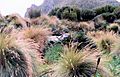
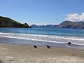
The landscape of Campbell Island during a warm, dry summer
-
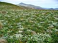
Campbell Island landscape with large plants called megaherbs
-
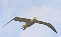
A southern royal albatross flying
-
A southern royal albatross with its chick on a nest
-
Sea lions playing at Northwest Bay


_with_chick_on_Campbell_Island.jpg)

See also
 In Spanish: Isla Campbell (Nueva Zelanda) para niños
