Bartow County, Georgia facts for kids
Quick facts for kids
Bartow County
|
|||
|---|---|---|---|

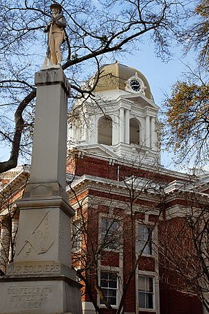
Bartow County Courthouse and Confederate Monument
|
|||
|
|||

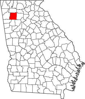
Location within the U.S. state of Georgia
|
|||
 Georgia's location within the U.S. |
|||
| Country | |||
| State | |||
| Founded | December 3, 1832 | ||
| Named for | Francis S. Bartow | ||
| Seat | Cartersville | ||
| Largest city | Cartersville | ||
| Area | |||
| • Total | 470 sq mi (1,200 km2) | ||
| • Land | 460 sq mi (1,200 km2) | ||
| • Water | 11 sq mi (30 km2) 2.2%% | ||
| Population
(2020)
|
|||
| • Total | 108,901 | ||
| • Estimate
(2023)
|
115,041 |
||
| • Density | 231.7/sq mi (89.5/km2) | ||
| Time zone | UTC−5 (Eastern) | ||
| • Summer (DST) | UTC−4 (EDT) | ||
| Congressional district | 11th | ||
Bartow County is located in the northwest part of the U.S. state of Georgia. In 2020, about 108,901 people lived here. The main city and county seat is Cartersville. Bartow County is also considered part of the larger Atlanta metropolitan area. It is known for having a "sole commissioner" government, which means one person leads the county's government.
Contents
History of Bartow County
Bartow County was created on December 3, 1832. It was first called Cass County. This name honored General Lewis Cass, who was an important government official. He played a role in moving Native American tribes from the area.
However, the county's name was changed on December 6, 1861. It was renamed in honor of Francis S. Bartow. This change happened because Lewis Cass supported the Union during the time leading up to the Civil War. Francis S. Bartow was a leader who supported the Southern states.
The Great Locomotive Chase
The American Civil War reached Bartow County in 1862. This was during an event called "The Great Locomotive Chase." Union soldiers secretly boarded and stole a train called "The General." Their plan was to travel north towards Chattanooga, Tennessee. They wanted to destroy bridges and railroad tracks along the way. This would stop supplies from reaching the Confederate army.
However, the Union soldiers could not damage the railroad enough. The train's conductor, William Fuller, chased them. He eventually caught up with them near Ringgold.
After the Civil War
The first county seat was Cassville. But after the Civil War, the courthouse was burned. The county seat then moved to Cartersville, where it is today.
The Civil War greatly affected Bartow County. Many soldiers from the county died from wounds or sickness. After the war, many people had no money. The county seat was in ruins. Transportation was damaged, and people faced hunger due to bad harvests.
Before the war, society in Bartow County was mostly white. After the war, during a time called Reconstruction, things changed. There were tensions, especially about race. For example, when the state sent corn to help people, local officials only gave it to white families. When black families asked for better schools and jobs, some local white people reacted with violence.
Geography of Bartow County
Bartow County covers about 470 square miles. Most of this area, about 460 square miles, is land. The remaining 11 square miles, or 2.2%, is water.
Most of the county is in the Etowah River area. This river is part of a larger river system called the ACT River Basin. A smaller part of the county in the northeast is near the Coosawattee River. Another small part in the northwest is near the Oostanaula River.
The Etowah River forms a large part of Lake Allatoona. This lake is in the southeast of Bartow County. The Allatoona Dam near Cartersville helps create the lake. A piece of land between two parts of the lake is home to Red Top Mountain State Park.
Neighboring Counties
- Gordon County – to the north
- Pickens County – to the northeast
- Cherokee County – to the east
- Cobb County – to the southeast
- Paulding County – to the south
- Polk County – to the southwest
- Floyd County – to the west
Population Information
| Historical population | |||
|---|---|---|---|
| Census | Pop. | %± | |
| 1840 | 9,390 | — | |
| 1850 | 13,300 | 41.6% | |
| 1860 | 15,724 | 18.2% | |
| 1870 | 16,566 | 5.4% | |
| 1880 | 18,690 | 12.8% | |
| 1890 | 20,616 | 10.3% | |
| 1900 | 20,823 | 1.0% | |
| 1910 | 25,388 | 21.9% | |
| 1920 | 24,527 | −3.4% | |
| 1930 | 25,364 | 3.4% | |
| 1940 | 25,283 | −0.3% | |
| 1950 | 27,370 | 8.3% | |
| 1960 | 28,267 | 3.3% | |
| 1970 | 32,663 | 15.6% | |
| 1980 | 40,760 | 24.8% | |
| 1990 | 55,911 | 37.2% | |
| 2000 | 76,019 | 36.0% | |
| 2010 | 100,157 | 31.8% | |
| 2020 | 108,901 | 8.7% | |
| 2023 (est.) | 115,041 | 14.9% | |
| U.S. Decennial Census 1790-18801890-1910 1920-1930 1930-1940 1940-1950 1960-1980 1980-2000 2010 2020 |
|||
2020 Census Details
| Race | Num. | Perc. |
|---|---|---|
| White (non-Hispanic) | 80,159 | 73.61% |
| Black or African American (non-Hispanic) | 11,309 | 10.38% |
| Native American | 254 | 0.23% |
| Asian | 1,169 | 1.07% |
| Pacific Islander | 40 | 0.04% |
| Other/mixed | 5,219 | 4.79% |
| Hispanic or Latino | 10,751 | 9.87% |
In 2020, there were 108,901 people living in Bartow County. There were about 39,742 households and 28,529 families.
2010 Census Details
In 2010, Bartow County had 100,157 people. The population density was about 218 people per square mile. Most residents were white (82.7%). About 10.2% were Black or African American. People of Hispanic or Latino origin made up 7.7% of the population.
Education
Public schools in Bartow County are managed by two main groups. These are the Bartow County School District and Cartersville City Schools. There are also private schools like Excel Christian Academy and Trinity School.
Transportation
Major Highways
Other Highways
- Old S.R. 293
Museums to Explore
Bartow County has several interesting museums:
- The Savoy Automobile Museum lets you explore the history and beauty of cars. It has different exhibits and educational programs.
- The Bartow History Museum is in the old 1869 Courthouse in Cartersville. It shows how Bartow County developed, from the early Cherokee people to modern times. You can see old photos and artifacts.
- The Booth Western Art Museum is a large museum in Cartersville. It shows art about the American West. You can see paintings, presidential letters, and Native American artifacts. There's even a special kids' gallery called Sagebrush Ranch.
- The Tellus Science Museum is also in Cartersville. It's a big museum with four main galleries. You can see minerals, fossils, and learn about science in motion. It also has a planetarium and an observatory to look at stars.
- The Euharlee History Museum is next to the Euharlee Covered Bridge. It tells the story of the Euharlee area.
- The Adairsville Rail Depot Age of Steam Museum is in a restored 1847 train station. It displays items and pictures from almost 150 years of local history. You can learn about the Civil War and railroad history.
Fun Things to Do
- You can explore many hiking trails in Bartow County.
- Visit the Etowah Indian Mounds, which are ancient Native American mounds.
Communities in Bartow County
Cities
Town
Unincorporated Communities
These are smaller communities not officially part of a city or town:
- Atco
- Cassville
- Rowland Springs
- Stilesboro
- Rydal
- Folsom
- Center
- Funkhouser
- Allatoona (much of it is now under Lake Allatoona)
Historical Communities
| Allatoona | Aylmer | ATCO | Aubrey | Bartow |
| Best's | Birmingham | Bochee | Bolivar | Cass Line |
| Cass Station | Cassville (Manassas) | Cave | Cement | Center |
| Clifford | Connaseena | Corbin | Dewey | Etowah |
| Etowah Valley (see Rowland Springs) | Eves | Ferrobutte (see Rogers Station) | Five Forks | Flexatile (see Funkhouser) |
| Folsom | Ford | Grassdale | Gum Springs | Halls Station (see Linwood) |
| Iron Hill | Ironville | Junta | Ladds | Ligon |
| Linwood (see Hall's Station) | Little Prairie | Malbone | McCallie | McGinnis |
| Mountain House | Murchisons | Nolans | Pine Log (see Rydal) | Rogers Station (aka Rogersville) |
| Rowland Springs (see Etowah Valley) | Ruby | Rydal (see Pine Log) | Sanfordsville | Sophia |
| Stamp Creek | Stilesboro | Sugar Hill | Woolley's | Wyvern |
See also
 In Spanish: Condado de Bartow para niños


