
Charlotte, Vermont facts for kids
Quick facts for kids
Charlotte, Vermont
|
|
|---|---|

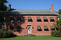
Charlotte town hall
|
|

Location in Chittenden County and the state of Vermont.
|
|

Charlotte, Vermont
Location in the United States
|
|
| Country | United States |
| State | Vermont |
| County | Chittenden |
| Communities | Cedar Beach East Charlotte Prindle Corners West Charlotte |
| Area | |
| • Total | 50.3 sq mi (130.4 km2) |
| • Land | 41.3 sq mi (106.9 km2) |
| • Water | 9.1 sq mi (23.6 km2) |
| Elevation | 354 ft (108 m) |
| Population
(2020)
|
|
| • Total | 3,912 |
| • Density | 95/sq mi (36.6/km2) |
| Time zone | UTC-5 (Eastern (EST)) |
| • Summer (DST) | UTC-4 (EDT) |
| ZIP code |
05445
|
| Area code(s) | 802 |
| FIPS code | 50-13300 |
| GNIS feature ID | 1462068 |
Charlotte is a friendly town located in Chittenden County, Vermont, in the United States. This town was named after Queen Charlotte. Unlike some other places named after her, the name "Charlotte" here is said with the accent on the second part, like "shar-LOTT". In 2020, about 3,912 people lived in Charlotte.
Contents
Geography of Charlotte
Charlotte is in the southwest part of Chittenden County. It shares its northern border with the town of Shelburne. To the east, you'll find Hinesburg. To the southeast and south, it borders Monkton and Ferrisburgh, both in Addison County.
To the west, Charlotte reaches the middle of Lake Champlain, which is the border between Vermont and New York. The town covers about 50.3 square miles (130.4 km2) in total. Most of this is land (41.3 square miles (106.9 km2)), and the rest (about 18%) is water.
You can find the village of East Charlotte in the eastern part of the town. On the west side, near U.S. Route 7, is West Charlotte. People sometimes call this area "the West Village."
Charlotte is also home to Mount Philo, a mountain about 990-foot-high (300 m). This park opened in 1924 and is a popular spot for outdoor fun. It is open during certain seasons of the year.
Charlotte's Population
.jpg)
The number of people living in Charlotte has changed over time. Here's how the population has grown:
| Historical population | |||
|---|---|---|---|
| Census | Pop. | %± | |
| 1790 | 635 | — | |
| 1800 | 1,231 | 93.9% | |
| 1810 | 1,679 | 36.4% | |
| 1820 | 1,526 | −9.1% | |
| 1830 | 1,702 | 11.5% | |
| 1840 | 1,620 | −4.8% | |
| 1850 | 1,634 | 0.9% | |
| 1860 | 1,589 | −2.8% | |
| 1870 | 1,430 | −10.0% | |
| 1880 | 1,342 | −6.2% | |
| 1890 | 1,240 | −7.6% | |
| 1900 | 1,254 | 1.1% | |
| 1910 | 1,163 | −7.3% | |
| 1920 | 1,160 | −0.3% | |
| 1930 | 1,089 | −6.1% | |
| 1940 | 1,082 | −0.6% | |
| 1950 | 1,215 | 12.3% | |
| 1960 | 1,271 | 4.6% | |
| 1970 | 1,802 | 41.8% | |
| 1980 | 2,561 | 42.1% | |
| 1990 | 3,148 | 22.9% | |
| 2000 | 3,569 | 13.4% | |
| 2010 | 3,754 | 5.2% | |
| 2020 | 3,912 | 4.2% | |
| U.S. Decennial Census | |||
In 2000, there were 3,569 people living in Charlotte. There were 1,287 households, which are groups of people living together. About 990 of these were families.
Many households (42.6%) had children under 18 living there. Most households (66.7%) were married couples. About 15.7% of households were single people living alone. The average household had about 2.77 people.
The population was spread out by age. About 29.7% of residents were under 18. About 30.1% were between 45 and 64 years old. The average age in Charlotte was 39 years.
Getting Around Charlotte
Major Roads
Two main roads help people travel through Charlotte:
 U.S. Route 7 goes from north to south through the town.
 Vermont Route F-5 goes from east to west. It connects U.S. Route 7 in West Charlotte to the ferry dock.
Ferry Service
A ferry service connects Charlotte to Essex, New York across Lake Champlain. The Lake Champlain Transportation Company runs this ferry every hour. For most of the past ten years, the ferry has run all year. It only stops for a few days if the lake is very rough or full of ice in winter.
There is also a special bus for people who travel to work. This bus stops on U.S. Route 7 at Ferry Road. It takes people to and from Burlington in the mornings and evenings.
Train Travel
Since 2022, you can also take a train near Charlotte. The Amtrak Ethan Allen Express train stops in Vergennes. This town is about 11 miles south of Charlotte.


Local News in Charlotte
Charlotte has two local newspapers that keep residents informed:
- The Citizen is a weekly newspaper. It is sent to all homes in Charlotte and nearby Hinesburg. It started in 2006 as the Charlotte Citizen. In 2011, it expanded to Hinesburg and changed its name. In 2017, it became part of the Vermont Community Newspaper Group.
- The Charlotte News is a newspaper that comes out every other Thursday. It is delivered to all homes in Charlotte. This newspaper started in 1958. It is an independent, non-profit organization. The Friends of the Charlotte News also help support this local newspaper.
Gallery
-
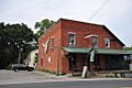
The "Old Brick Store" in the West Village.
-
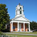
Charlotte Congregational Church in the Charlotte Center Historic District.
-
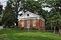
Charlotte Memorial Museum (formerly known as the Town Meeting House), which currently houses the Charlotte Historical Society.
-

View of Camel's Hump Mountain from East Charlotte.
-
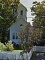
School house on Greenbush Road, originally built in 1881 and formerly known as the Lakeview Seminary where John Dewey served as its first principal.
-
The 1812 Tavern on Church Hill Road.


Famous People from Charlotte
Many interesting people have lived in Charlotte, including:
- Jamie Aube, a racing driver
- Hezekiah Barnes, a major general
- John Dewey, a famous American psychologist and educator
- Wilfred Grenfell, a medical helper
- Jeffrey Hollender, an American businessperson
- Melvin Kaplan, an oboist and concert organizer
- Dan Kiley, a landscape architect
- Abel E. Leavenworth, an educator and soldier
- Cyrus Pringle, a botanist
See also
 In Spanish: Charlotte (Vermont) para niños
