
Shelburne, Vermont facts for kids
Quick facts for kids
Shelburne, Vermont
|
|
|---|---|

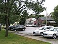
A section of central Shelburne
|
|

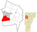
Location in Chittenden County and the state of Vermont.
|
|

Shelburne, Vermont
Location in the United States
|
|
| Country | United States |
| State | Vermont |
| County | Chittenden |
| Communities | Shelburne Shelburne Falls |
| Area | |
| • Total | 45.1 sq mi (116.7 km2) |
| • Land | 24.3 sq mi (63.0 km2) |
| • Water | 20.8 sq mi (53.8 km2) |
| Elevation | 203 ft (62 m) |
| Population
(2020)
|
|
| • Total | 7,717 |
| • Density | 317/sq mi (122.5/km2) |
| Time zone | UTC-5 (Eastern (EST)) |
| • Summer (DST) | UTC-4 (EDT) |
| ZIP code |
05482
|
| Area code(s) | 802 |
| FIPS code | 50-64300 |
| GNIS feature ID | 1462206 |
Shelburne is a town in Chittenden County, Vermont, United States. It is located right by Lake Champlain. Shelburne's town center is about 7 miles (11 km) south of Burlington. Burlington is the biggest city in Vermont. In 2020, about 7,717 people lived in Shelburne.
The main part of Shelburne is called a census-designated place (CDP). This means it's a specific area the census counts. In 2020, 6,178 people lived in this main area. Shelburne has a high average income compared to other places in Chittenden County and the Burlington area.
Contents
History of Shelburne
Shelburne was officially started on August 18, 1763. It was given to Jesse Hallock and 64 friends by Governor Benning Wentworth of New Hampshire. The town was named after William Petty, 2nd Earl of Shelburne. He was a famous nobleman in the British parliament and a Prime Minister. The original plan was for the town to be about 23,500 acres (95 km²). But due to a mistake by surveyors, it ended up being smaller.
From the very beginning, farming was the main way people made a living in Shelburne. When settlers cleared land and burned logs, they created a lot of potash. Potash was important for making soap and fertilizer. Mills were built on the La Platte River at Shelburne Falls. These mills helped process wool, grind grain, and cut wood. There was also a blacksmith shop.
In 1811, some Merino sheep were brought from Spain. This led to a big increase in sheep farming. Growing fruit also became very important for farmers. By 1880, there were about 17,740 fruit trees. After the War of 1812, trade on Lake Champlain grew quickly.
The Lake Champlain Transportation Company built its ships in Shelburne Harbor. They launched their first steamboat, the General Green, in 1825. They built ten more steamboats before the Ticonderoga in 1906. In 1955, the Ticonderoga was moved over land to the Shelburne Museum. You can still see it there today.
Geography of Shelburne
Shelburne covers a total area of about 116.7 square kilometers (45.1 sq mi). About 63.0 square kilometers (24.3 sq mi) of this is land. The rest, about 53.8 square kilometers (20.8 sq mi), is water. Most of this water is part of Lake Champlain. Shelburne Pond, located in the eastern part of town, is also a water body.
Shelburne's Population
| Historical population | |||
|---|---|---|---|
| Census | Pop. | %± | |
| 1790 | 389 | — | |
| 1800 | 723 | 85.9% | |
| 1810 | 987 | 36.5% | |
| 1820 | 936 | −5.2% | |
| 1830 | 1,123 | 20.0% | |
| 1840 | 1,089 | −3.0% | |
| 1850 | 1,257 | 15.4% | |
| 1860 | 1,178 | −6.3% | |
| 1870 | 1,190 | 1.0% | |
| 1880 | 1,096 | −7.9% | |
| 1890 | 1,300 | 18.6% | |
| 1900 | 1,202 | −7.5% | |
| 1910 | 1,097 | −8.7% | |
| 1920 | 997 | −9.1% | |
| 1930 | 1,006 | 0.9% | |
| 1940 | 1,010 | 0.4% | |
| 1950 | 1,365 | 35.1% | |
| 1960 | 1,805 | 32.2% | |
| 1970 | 3,728 | 106.5% | |
| 1980 | 5,000 | 34.1% | |
| 1990 | 5,871 | 17.4% | |
| 2000 | 6,944 | 18.3% | |
| 2010 | 7,144 | 2.9% | |
| 2020 | 7,717 | 8.0% | |
| U.S. Decennial Census | |||
In 2000, there were 6,944 people living in Shelburne. The town had 2,632 households. Many households had children under 18 living with them. The population was spread out across different age groups. About 27.6% of the people were under 18 years old. The average age in Shelburne was 41 years.
Economy and Jobs in Shelburne

Shelburne has many different businesses. These include companies that make things, offer services, and sell goods. It also has Vermont's largest retirement community. In 2007, an old inn was turned into offices, small shops, and a restaurant.
Personal Income
In 2016, the average income for a household in Shelburne was $98,898. For families, the average income was $118,492. This shows that Shelburne is a fairly wealthy area. A small number of families and people lived below the poverty line.
Fun Places to Visit
Shelburne has three main places that attract tourists. These are the Shelburne Museum, Shelburne Farms, and the Vermont Teddy Bear Company. Other popular spots include Shelburne Vineyard and Fiddlehead Brewery.
The town also has a beach on Lake Champlain. This beach has a place to launch boats and a nature park.
Getting Around Shelburne
U.S. Route 7 is a main road that goes through the center of Shelburne. It goes north towards South Burlington and south towards Vergennes.
Bus service in Shelburne is provided by Green Mountain Transit.
Schools in Shelburne
Shelburne has several schools for different ages.
Public Schools
- Shelburne Community School (for elementary and middle school students)
High school students from Shelburne go to Champlain Valley Union High School. This high school is located in Hinesburg.
Private Schools
- Vermont Day School
- Lake Champlain Waldorf School
Preschools
- Heartworks (Shelburne campus)
- Shelburne Nursery School
Other Schools
- Shelburne Craft School
Shelburne News
The Shelburne News is a weekly newspaper. It is sent to all homes in Shelburne. The newspaper started in 1967. In 2017, it was sold to the owners of the Stowe Reporter. They then created the Vermont Community Newspaper Group in 2019.
Famous People from Shelburne
Many interesting people have lived in Shelburne, including:
- Frederic W. Allen, a Chief Justice of the Vermont Supreme Court.
- John L. Barstow, a former Governor of Vermont.
- Michael Dante DiMartino, an animation director. He helped create Avatar: The Last Airbender.
- Madeleine Kunin, a former governor of Vermont.
- Kevin Lepage, a stock car racer.
- Lucius Lyon, one of the first U.S. senators from Michigan.
- Megan Nick, an Olympic bronze medalist in Aerial skiing.
- Richard Snelling, a former governor of Vermont.
- Jane Swift, a former acting governor of Massachusetts.
- Electra Havemeyer Webb, who started the Shelburne Museum.
- William Seward Webb, who started Shelburne Farms.
Images for kids
-
A section of central Shelburne
-
Location in Chittenden County and the state of Vermont.
-
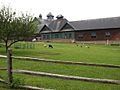
Shelburne Farms
See also
 In Spanish: Shelburne (Vermont) para niños
