Chase County, Nebraska facts for kids
Quick facts for kids
Chase County
|
|
|---|---|

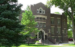
Chase County courthouse in Imperial
|
|

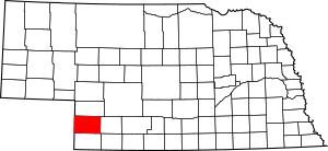
Location within the U.S. state of Nebraska
|
|
 Nebraska's location within the U.S. |
|
| Country | |
| State | |
| Founded | February 27, 1873 (authorized) 1886 (organized) |
| Named for | Champion S. Chase |
| Seat | Imperial |
| Largest city | Imperial |
| Area | |
| • Total | 897 sq mi (2,320 km2) |
| • Land | 894 sq mi (2,320 km2) |
| • Water | 3.1 sq mi (8 km2) 0.5%% |
| Population
(2020)
|
|
| • Total | 3,893 |
| • Density | 4.3400/sq mi (1.6757/km2) |
| Time zone | UTC−7 (Mountain) |
| • Summer (DST) | UTC−6 (MDT) |
| Congressional district | 3rd |
Chase County is a county located in the state of Nebraska in the United States. As of the 2020 United States Census, about 3,893 people lived there. The main town and center of the county government, called the county seat, is Imperial.
When Nebraska started its license plate system in 1922, Chase County was given the number 72. This was because it had the 72nd most vehicles registered in the state at that time.
Contents
History of Chase County
Chase County got its name from Champion S. Chase. He was an important person who served as the mayor of Omaha for seven years. He was also Nebraska's very first Attorney General, which is like the state's top lawyer.
The Nebraska government decided to create Chase County on February 27, 1873. It was separated from Hayes County. However, the county didn't officially start its own government until 1886.
Long ago, people used to say that Chase County was mostly filled with cowboys. This was because Frenchman Creek and its branch, Stinking Water Creek, were important stops. They provided water for huge cattle drives. These drives brought cattle all the way from Texas to a train station in Ogallala. These routes were known as the Western or Great Western trails.
Chase County is in a region that was once called the Great American Desert. But early settlers soon found out that the dark, sandy soil was great for farming. This made the area very fertile.
The railroad arrived in Chase County in 1892. It reached the town of Wauneta on January 28. This railway line was built by a part of the Chicago, Burlington and Quincy Railroad. It connected to the main line near Culbertson and ended in Imperial.
Historic Places in Chase County
Several places in Chase County are listed on the National Register of Historic Places. This means they are important for their history.
- In Imperial:
- Balcony House (listed in 2000)
- Chase County Court House (listed in 1990)
- In Wauneta:
- Wauneta Roller Mills (listed in 2008)
- In Champion:
- Champion Mill (listed in 1988)
- In Rural Areas:
- Lovett Site (listed in 1972)
- Texas Trail Stone Corral (listed in 2002), located north of Imperial on Spring Creek
Geography of Chase County
Chase County is located on the western edge of Nebraska. Its western border touches the eastern border of the state of Colorado. The US Census Bureau says the county covers about 897 square miles. Most of this, about 894 square miles, is land. Only a small part, about 3.1 square miles, is water.
The county has different types of land. The Frenchman Creek, which is fed by springs, flows across the county. It goes from west to southeast. Between the towns of Enders and Wauneta, the creek shows limestone rocks. North of Wauneta, you can find many loess deposits. These are deep layers of fine soil that form steep canyons. In the north-central and southwestern parts of the county, you'll see rolling Sandhill formations.
Underneath the ground, there's a layer of rock called Pierre Shale. Above that is the Ogallala Formation. This formation is made of sand, gravel, and clay. It's very important because it holds the Ogallala Aquifer. This aquifer is a huge underground water source. It provides most of the water for people, animals, and farms in Chase County and the areas around it.
Neighboring Counties
Chase County shares borders with several other counties:
- Hayes County – to the east
- Dundy County – to the south
- Yuma County, Colorado – to the southwest
- Phillips County, Colorado – to the west
- Perkins County – to the north
Protected Natural Areas
- Church Grove Recreation Area
- Enders Reservoir State Recreation Area
Population of Chase County
| Historical population | |||
|---|---|---|---|
| Census | Pop. | %± | |
| 1880 | 70 | — | |
| 1890 | 4,807 | 6,767.1% | |
| 1900 | 2,559 | −46.8% | |
| 1910 | 3,613 | 41.2% | |
| 1920 | 4,939 | 36.7% | |
| 1930 | 5,484 | 11.0% | |
| 1940 | 5,310 | −3.2% | |
| 1950 | 5,176 | −2.5% | |
| 1960 | 4,317 | −16.6% | |
| 1970 | 4,129 | −4.4% | |
| 1980 | 4,758 | 15.2% | |
| 1990 | 4,381 | −7.9% | |
| 2000 | 4,068 | −7.1% | |
| 2010 | 3,966 | −2.5% | |
| 2020 | 3,893 | −1.8% | |
| US Decennial Census 1790-1960 1900-1990 1990-2000 2010 |
|||
According to the 2000 United States Census, there were 4,068 people living in Chase County. The population density was about 4 people per square mile.
The county's population included about 25.2% of people under 18 years old. About 21.1% of the population was 65 years or older. The average age in the county was 42 years.
Economy of Chase County
The economy of Chase County is mostly based on agriculture. This means farming and raising animals. About one-third of the county's land is watered by irrigation. Another one-fourth of the land is used for dry farming, which relies on rainfall. The rest of the land is used for rangeland, where animals graze.
The main crops grown here are wheat, corn, and different kinds of beans like pintos. Soybeans and sugar beets are also important. Raising livestock, such as cattle, is also a big part of the county's economy. In 2007, the sales from farm products were over $125 Million. Corn was the biggest crop, bringing in $96 Million, and wheat brought in $11 Million.
Transportation in Chase County
The main roads that cross Chase County are U.S. Route 6 and Nebraska Highway 61. U.S. Highway 6 runs from east to west. Nebraska Highway 61 runs from north to south.
The county also has a railway line. It is operated by the Nebraska Kansas & Colorado Railway (NKCR). This short line connects with the BNSF railway. The line enters Chase County near the southeastern corner. It passes through Wauneta and Enders, and ends in Imperial.
Main Highways
Communities in Chase County
City
- Imperial (This is the county seat, where the main government offices are.)
Villages
Census-designated places
These are areas that are like towns but are not officially incorporated as cities or villages.
Former Communities
These are places that used to be communities but are no longer active or recognized as such.
- Best
- Blanche
- Chase
- Lamar (This community was officially unincorporated on November 5, 2024.)
Notable people
- Lee Edward Travis - a famous psychiatrist and speech pathologist.
See also
 In Spanish: Condado de Chase (Nebraska) para niños

