
Chatsworth, Los Angeles facts for kids
Quick facts for kids
Chatsworth
|
|
|---|---|

Chatsworth neighborhood as mapped by the Los Angeles Times
|
|

Chatsworth
Location in San Fernando Valley
|
|
| Country | United States |
| State | California |
| County | Los Angeles |
| City | Los Angeles |
| Named for | Chatsworth House |
| Elevation | 978 ft (298 m) |
| Population
(2000)
|
|
| • Total | 41,255 |
| Time zone | UTC-8 (PST) |
| • Summer (DST) | UTC-7 (PDT) |
| ZIP code |
91311
|
| Area code(s) | 747 and 818 |
Chatsworth is a lively neighborhood in Los Angeles, California, located in the San Fernando Valley. It's a suburban area, meaning it's mostly residential with homes and businesses.
Long ago, Native American tribes lived here, leaving behind amazing rock art in caves. Later, in the 1700s, Spanish explorers arrived and settled the area. The land became part of a huge Spanish land grant. After the Mexican–American War, the United States took over, and this land grant became one of the largest in California!
Today, Chatsworth has many schools, both public and private. It's also known for its beautiful open spaces and parks, perfect for outdoor activities. You'll find a public library and a transportation center here too. Two special places are the old Chatsworth Reservoir and the Santa Susana Field Laboratory.
Chatsworth has one of the lowest population densities in Los Angeles. This means there are fewer people living in each square mile. It also has a higher income level compared to other areas.
Did you know Chatsworth is home to the Iverson Movie Ranch? This huge 500-acre area was used for filming over 2,000 movies and TV shows, making it the most filmed movie ranch ever!
Contents
Population and People
In 2000, about 35,073 people lived in Chatsworth. This means there were about 2,301 people per square mile. This is considered a low population density for Los Angeles. By 2008, the population grew to about 37,102. The average age of residents in 2000 was 40, which is a bit older than other neighborhoods in the city.
Chatsworth is known for having a mix of different cultures. There are many white and Asian residents, along with a large Hispanic/Latino community. About 25% of the people living here were born in other countries. The most common places of birth were Korea and the Philippines.
The average yearly household income in 2008 was about $84,456. This is considered a high income for Los Angeles. Most people in Chatsworth own their homes or apartments, with about 71% being homeowners. The average household has about 2.6 people.
In 2000, about 10.8% of the population were military veterans. This is a high number compared to the rest of the city. Many people in Chatsworth are married, and fewer families are headed by single parents compared to other parts of Los Angeles.
Geography and Climate
Chatsworth is surrounded by natural beauty. To the north are the Santa Susana Mountains. To the east, you'll find Porter Ranch and Northridge. To the south are Winnetka, Canoga Park, and West Hills. To the west are the Simi Hills and parts of Ventura County. There's also a community called Twin Lakes to the north, which has a large park with trails for horses.
Climate
Chatsworth has a warm-summer Mediterranean climate. This means it has hot and dry summers. The average daily high temperatures in summer are usually between 90 and 100 degrees Fahrenheit (32-38 degrees Celsius).
History of Chatsworth
Early Inhabitants
For about 8,000 years, different Native American tribes lived in the Chatsworth area. These included the Tongva, Chumash, and Tataviam tribes. Stoney Point was once a Tongva village called Momonga. It was also a place where tribes traded goods. The nearby Burro Flats Painted Cave shows amazing rock art left by the Chumash culture. These paintings often related to their spiritual beliefs and ceremonies, like those for the solstice.
Spanish and Mexican Influence
The first European explorers arrived in the Chatsworth area on August 5, 1769. They were led by the Spanish military leader Gaspar de Portolà. In 1797, the Mission San Fernando was built. The King of Spain then gave the mission control over all the lands in the San Fernando Valley, including what would become Chatsworth.

An old Native American trail connected the village of Santa Susana (Chatsworth) to the Mission San Fernando. This trail became an important route for Spanish missionaries and travelers. It was part of the El Camino del Santa Susana y Simi trail. This trail connected the Mission, the town of Los Angeles, and other missions to the south with those to the north. It crossed over the Santa Susana Pass into the Simi Valley. Today, parts of this trail can be found in Chatsworth Park South and the Santa Susana Pass State Historic Park.
After Mexico gained independence from Spain in 1821, the Mission San Fernando became part of Mexico. In 1846, the Mexican government gave a large land grant called Rancho Ex-Mission San Fernando. This huge piece of land included most of what is now Chatsworth. After the United States took control, this land grant was confirmed in 1873 and became the single largest land grant in California.
How Chatsworth Got Its Name
The name "Chatsworth" comes from the grand Chatsworth House in England. In 1888, a man named George R. Crow created a map of the San Fernando Valley. On this map, he named a new area "Chatsworth Park." William Booth Barber, who was from England and lived near the original Chatsworth House, later filed another map in 1893, calling it the "Plat of Chatsworth Park Townsite." This is how the area got its famous name.
The Old Santa Susana Stage Road was an important route from 1861 to 1875. It connected Los Angeles and San Francisco. A difficult part of this road was called "The Devil's Slide." A new, easier road was built in 1895, which was later named the Chatsworth Grade Road. This road was used until 1917, when Santa Susana Pass Road was built. Later, the 118 Ronald Reagan Freeway was built, making travel even faster.
The Chatsworth Historical Society was started in 1963. Its goal was to save the historic Pioneer Church from being torn down. Today, the society and the Chatsworth Museum are located in Chatsworth Park South. They work to preserve Chatsworth's history and teach people about it.
Education
About 34% of Chatsworth residents aged 25 and older have earned a four-year degree. This is about average for the city of Los Angeles.
Schools in Chatsworth
Here are some of the schools located within Chatsworth:
Public Schools

- Chatsworth Senior High School
- William Tell Aggeler Opportunity High School
- Stoney Point Continuation School
- Ernest Lawrence Middle School
- Germain Street Elementary School
- Chatsworth Park Elementary School
- Superior Street Elementary School
- Our Community School
Private Schools
- Sierra Canyon School (pre-kindergarten through 12th grade)
- Chatsworth Hills Academy (elementary)
- St. Paul's Christian Academy
- Al-Falaq / Me'raj Academy (elementary)
- Egremont Schools, Inc. (elementary)
- Chaminade College Preparatory School (middle school)
- St. John Eudes (elementary)
- Monarch Christian School
Parks and Recreation
Chatsworth has many parks and open spaces for everyone to enjoy. These parks are managed by different groups, including the City of Los Angeles Parks and Recreation Department.
Open-Space Parks

- Chatsworth Park North: This park has over 20 acres (8 hectares) of the beautiful Simi Hills. It has baseball fields, a football field, basketball courts, volleyball courts, and a children's play area. You can also find hiking trails, a jogging path, and picnic areas with barbecue pits.
- Chatsworth Park South: This park covers more than 100 acres (40 hectares) of the rocky Simi Hills. It's right next to the Santa Susana Pass State Historic Park. This historic park has old features and parts of the Old Santa Susana Stage Road. This road was once the main route for mail and travelers between Los Angeles and San Francisco. The park has miles of trails for horseback riding, jogging, and hiking. There are also picnic tables and places for bouldering.
- The Chatsworth Recreation Center is located here. It has indoor and outdoor basketball courts, a gym, a stage, and tennis courts.
- The Minnie Hill Palmer House, one of the oldest homes in the West Valley, is also in Chatsworth Park South. You can visit it and learn about local history.
- Michael D. Antonovich Park at the Joughin Ranch: This huge park has over 1,600 acres (647 hectares) of hiking and equestrian trails, creeks, and waterfalls.
- Santa Susana Pass State Historic Park (SSPSHP): This large natural area is next to Chatsworth's western side. It protects a historical site from the late 1800s. The Old Stagecoach Trail here is now a popular hiking trail. The park is open to the public with many trails and great views.
- Chatsworth Oaks Park: This park is about 3 acres (1.2 hectares) of natural open space. It has barbecue pits, a children's play area, and picnic tables. You can bike and hike here, and it connects to the Santa Susana Pass State Historic Park. From here, you can see the Chatsworth Nature Preserve and watch birds.

- Stoney Point Park: This park is a natural rock formation and a famous spot for bouldering and rock climbing. It covers about 76 acres (31 hectares). The rocks form cool alcoves, caves, and dens. The park also has trails for horses and hiking, and it connects to other parks. Stoney Point is believed to be the site of an old Tongva village.
- Chatsworth Trails Park: Located in the Santa Susana Mountains foothills, this park has miles of trails for horseback riding, hiking, and mountain biking. It also connects to other large parks like the Michael D. Antonovich Regional Park.
- Sage Ranch Park: This park overlooks Chatsworth from its high ridges in the Simi Hills. It's a new open space park with campsites, walking trails, and amazing views of the San Fernando and Simi Valleys.
Neighborhood Parks
- Mason Park: This park offers barbecue pits, baseball diamonds, a children's play area, and picnic tables.
- The Mason Recreation Center has an indoor gym that can also be used as an auditorium.
- The Mason Child Care Center provides educational and fun activities for children.
Chatsworth Reservoir
A special feature in Chatsworth is the Chatsworth Dam and reservoir. It was built in 1918 to be part of the Los Angeles Aqueduct system. However, it was taken out of service in 1969 due to concerns about water quality. After the 1971 San Fernando earthquake, it was no longer used for water storage because of safety concerns.
Chatsworth Oaks Park and the Chatsworth Nature Preserve are located here. They offer great views of migrating birds and other animals, and you can hear coyotes calling in the evening. The dramatic and rocky Simi Hills surround this open space.
Economy
Chatsworth is home to several businesses. The National Notary Association and the headquarters for Premier America (a credit union) are located here.
The Santa Susana Field Laboratory (SSFL) used to be a busy place where rocket engines were tested and nuclear research was done. It is now closed and will be cleaned up. After the cleanup, it will become an open-space park. This will add to Chatsworth's beautiful scenery and provide more hiking opportunities.
Some of the large companies that employ people in Chatsworth include Capstone Turbine, Natel Engineering, and Hydraulics International. Lamps Plus also has production and distribution facilities here.
In 1979, Seltzer Motor Industries in Chatsworth produced the Willow, a unique two-seat sports car kit.
Notable People
- Amari Bailey (born 2004), NBA basketball player
- Taurus Tremani Bartlett, or Polo G, American rapper
- Donald Friese (born 1940), billionaire businessman
- Doug Garwood, professional golfer
- Mike Moustakas, Major League Baseball player
- Larry Niven, science fiction and fantasy author
- Jenny Y. Yang, chemist
Images for kids
-
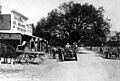
The center of Chatsworth in 1911, on what is now Topanga Canyon Boulevard.
.jpg)
See also
 In Spanish: Chatsworth (Los Ángeles) para niños
