City of St Albans facts for kids
Quick facts for kids
City and District of St Albans
|
||
|---|---|---|
| St Albans | ||

|
||
|
||

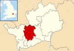
St Albans shown within Hertfordshire
|
||
| Sovereign state | United Kingdom | |
| Country | England | |
| Region | East of England | |
| Non-metropolitan county | Hertfordshire | |
| Status | Non-metropolitan district, Borough & City | |
| Admin HQ | St Albans | |
| Incorporated | 1 April 1974 | |
| Government | ||
| • Type | Non-metropolitan district council | |
| • Body | St Albans City and District Council | |
| Area | ||
| • Total | 62.23 sq mi (161.18 km2) | |
| Area rank | 177 (of 326) | |
| Population
(2005 est.)
|
||
| • Total | 147,095 | |
| • Rank | 141 (of 326) | |
| • Density | 2,363.66/sq mi (912.613/km2) | |
| Ethnicity (2021) | ||
| • Ethnic groups |
List
|
|
| Religion (2021) | ||
| • Religion |
List
47.4% Christianity
37.1% no religion 10.8% other 4.7% Islam |
|
| Time zone | UTC0 (GMT) | |
| • Summer (DST) | UTC+1 (BST) | |
| ONS code | 26UG (ONS) E07000100 (GSS) |
|
| OS grid reference | TL148073 | |
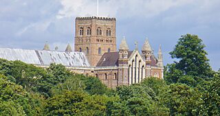
St Albans is a city and district in Hertfordshire, England. It is also known as the City and District of St Albans. The main office for the local government is in St Albans, which is the biggest town in the area. The district also includes the town of Harpenden and many villages. St Albans borders other areas like Welwyn Hatfield and Watford.
Contents
History of St Albans
The town of St Albans has been an important place for a long time. It was first given special rights as a borough in 1553. A borough is a town that governs itself. Later, in 1877, it officially became a city.
The modern St Albans district was created on April 1, 1974. This happened under a law called the Local Government Act 1972. The new district combined three older areas:
The new district was named St Albans because it was the largest settlement. It was given "borough status" right away. This meant the head of the council could be called the "mayor". This continued a tradition of mayors in St Albans that began in 1553. The entire new district was given "city status" on July 9, 1974. The council can call itself "St Albans City Council" but usually uses "St Albans City and District Council".
Exploring St Albans Geography
The biggest town in the district is St Albans. The next largest is Harpenden. Some of the main villages are Redbourn, Wheathampstead, London Colney, Chiswell Green, and Bricket Wood.
Other towns nearby include Hatfield and Welwyn Garden City to the east. Luton and Dunstable are to the north. Hemel Hempstead is to the west, and Watford is to the southwest. St Albans is quite close to Greater London, less than 4 miles (6.4 km) from its edge. The centre of St Albans is about 19 miles (30.6 km) from the centre of London.
How St Albans is Governed
| St Albans City and District Council | |
|---|---|
 |
|
| Type | |
| Type |
Non-metropolitan district council
|
| Leadership | |
|
Mayor
|
|
|
Leader
|
|
|
Amanda Foley
Since 17 July 2017 |
|
| Structure | |
| Seats | 56 |
|
Political groups
|
|
| Elections | |
|
Last election
|
2 May 2024 |
|
Next election
|
7 May 2026 |
| Meeting place | |
 |
|
| Civic Centre, St Peter's Street, St Albans, AL1 3JE | |
Hertfordshire has two levels of local government. The ten district councils, like St Albans City and District Council, handle local services. The Hertfordshire County Council handles bigger services for the whole county. Some areas also have smaller parish councils.
The County Council is in charge of things like schools, roads, fire safety, and libraries. The District Council handles things like elections, food safety, car parks, and parks. They also manage council housing, town planning, and street cleaning. Parish councils look after local projects, leisure facilities, and community transport.
Council Leadership
The Mayor of St Albans is mostly a ceremonial role. They lead council meetings and are the main representative of the district. The mayor is chosen from the councillors. They are expected to be fair and not take sides in politics. A different councillor usually becomes mayor each year.
The real political leader is the leader of the council. Here are the leaders since 2004:
| Councillor | Party | From | To | |
|---|---|---|---|---|
| Robert Donald | Liberal Democrats | 23 Jun 2004 | 18 May 2011 | |
| Julian Daly | Conservative | 18 May 2011 | 24 May 2017 | |
| Alec Campbell | Conservative | 24 May 2017 | 5 May 2019 | |
| Chris White | Liberal Democrats | 22 May 2019 | 5 May 2024 | |
| Paul De Kort | Liberal Democrats | 22 May 2024 | ||
Council Members
After the 2024 election, the council looks like this:
| Party | Councillors | |
|---|---|---|
| Liberal Democrats | 47 | |
| Conservative | 3 | |
| Green | 3 | |
| Labour | 2 | |
| Independent | 1 | |
| Total | 56 | |
The next election for the council is planned for May 2026.
Council Building
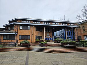
The council's main office is at the Civic Centre on St Peter's Street in St Albans. This building was built for the council in 1989. It even has a special emergency bunker in the basement.
Council Elections
The council has 56 councillors. The district is split into 20 areas called wards. Each ward elects one, two, or three councillors. Elections happen three out of every four years. About a third of the council is elected each time. In the fourth year, elections are held for the Hertfordshire County Council.
District Wards
The wards in the St Albans district are:
Local Parishes
Many areas in the district have their own local councils called parish councils. These include Colney Heath, Harpenden, Harpenden Rural, London Colney, Redbourn, St Michael, St Stephen, Sandridge, and Wheathampstead. Harpenden's parish council is called a "town council". The central part of St Albans does not have a parish council. Instead, a special committee of district councillors handles local matters there.
| Parish | Council | Population (2011) | Area (2011) |
|---|---|---|---|
| Colney Heath | Colney Heath Parish Council | 5,962 | 1,119 hectares (4.32 sq mi) |
| Harpenden | Harpenden Town Council | 29,448 | 1,278 hectares (4.93 sq mi) |
| Harpenden Rural | Harpenden Rural Parish Council | 405 | 923 hectares (3.56 sq mi) |
| London Colney | London Colney Parish Council | 9,507 | 513 hectares (1.98 sq mi) |
| Redbourn | Redbourn Parish Council | 5,344 | 1,908 hectares (7.37 sq mi) |
| Sandridge | Sandridge Parish Council | 11,451 | 1,518 hectares (5.86 sq mi) |
| St Michael | St Michael Parish Council | 477 | 2,120 hectares (8.2 sq mi) |
| St Stephen | St Stephen Parish Council | 13,865 | 2,329 hectares (8.99 sq mi) |
| Wheathampstead | Wheathampstead Parish Council | 6,410 | 2,599 hectares (10.03 sq mi) |
| Total parishes | 82,869 | 14,307 hectares (55.24 sq mi) | |
| St Albans (unparished) | City Neighbourhood Committee | 57,795 | 1,811 hectares (6.99 sq mi) |
| St Albans City and District | St Albans City and District Council | 140,664 | 16,118 hectares (62.23 sq mi) |
St Albans Economy
St Albans has a very skilled workforce. Many people who live and work here have university degrees. The average weekly earnings are much higher than the national average. St Albans also has very low unemployment, which means most people who want to work can find jobs.
Some big companies have offices in the district, like Deloitte, Spreadex, and PricewaterhouseCoopers. A large Sainsbury's distribution centre in London Colney employs over 600 people.
In 2024, the St Albans Market was named the Best Large Outdoor Market in the country.
Transport in St Albans
Several major roads run through the district. These include the M1 motorway, the M25 motorway, the A414 road, and the A1081 road.
The district has six railway stations. Two of them, St Albans City and Harpenden, are on the main Thameslink train line. This line connects Bedford to Brighton, going through London. The other four stations are on the Abbey Line branch line. This line runs from St Albans Abbey to Watford Junction.
Population of St Albans
In 2021, the population of St Albans City and District was 148,167 people. There were slightly more females than males. Most residents are White British. A large number of people identify as Christian, and many also say they have no religion.
St Albans Twin Towns
St Albans has "twin town" relationships with several places around the world. This means they have special friendly connections and often visit each other.
 Fano, Italy
 Nyíregyháza, Hungary
 Nevers, France
 Odense, Denmark
 Worms, Germany
 Nieuwleusen, Netherlands
 Sylhet, Bangladesh
St Albans also has "friendship links" with:
St Albans Coat of Arms
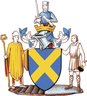
The Coat of Arms is a special symbol for the St Albans City and District Council. It shows different symbols that represent the history and importance of the area.
See also
 In Spanish: Distrito de St. Albans para niños
 | Aurelia Browder |
 | Nannie Helen Burroughs |
 | Michelle Alexander |


