Clipperton Island facts for kids
|
Native name:
La Passion–Clipperton (French)
|
|
|---|---|
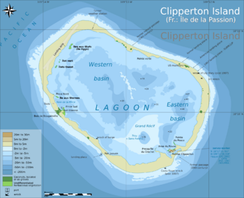
Clipperton Atoll with lagoon with depths (metres)
|
|

Location of Clipperton Island
|
|
| Geography | |
| Location | Pacific Ocean |
| Coordinates | 10°18′N 109°13′W / 10.300°N 109.217°W |
| Archipelago | Lagoon |
| Area | 8.9 km2 (3.4 sq mi) |
| Length | 3 km (1.9 mi) |
| Width | 4 km (2.5 mi) |
| Coastline | 11.1 km (6.9 mi) |
| Highest elevation | 29 m (95 ft) |
| Highest point | Clipperton Rock |
| Administration | |
|
France
|
|
| State private property | Île de Clipperton |
| Demographics | |
| Population | 0 (1945) |
| Additional information | |
| Time zone | |
| Postal code | 98799 |
|
|
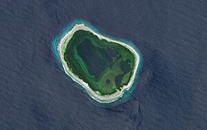
Clipperton Island is a small, uninhabited French coral atoll in the eastern Pacific Ocean. It is also known as Clipperton Atoll or by its French name, La Passion–Clipperton. This island is about 8.9 km2 (3.4 sq mi) in size.
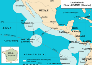
Clipperton is the only French territory in the North Pacific. It is very far from mainland France, about 10,675 km (6,633 mi) from Paris. It is closer to Mexico, about 1,280 km (690 nmi) from Acapulco.
French explorers first wrote about Clipperton in 1711. France officially claimed it in 1858. However, American miners started digging for guano (bird droppings used as fertilizer) there in the 1890s. Mexico also claimed the island, saying it was found by Spanish explorers in the 1520s.
In 1905, Mexico set up a small military base on the island. But during the Mexican Revolution, supplies stopped coming. Most of the people living there died. The lighthouse keeper, Victoriano Álvarez, took control for a short time. In 1917, eleven people were rescued, and the island was left empty.
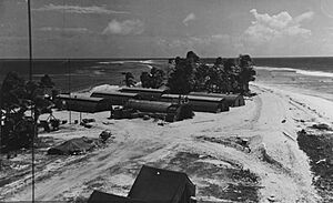
France and Mexico argued over who owned Clipperton. In 1931, the King of Italy, Victor Emmanuel III of Italy, decided that the island belonged to France. Clipperton stayed mostly empty until 1944. Then, the U.S. Navy built a weather station there during World War II. France did not like this, and the U.S. left the island in 1945.
Since World War II, Clipperton has been a place for scientists to study its plants and animals. It is home to many masked and brown booby birds. Climate scientists and amateur radio groups also visit. There have been ideas to build a port or tourist spots, but the island remains mostly empty. The French navy visits it sometimes.
Contents
Geography of Clipperton Island
Clipperton Island is a coral island located in the East Pacific. It is about 1,080 km (583 nmi) southwest of Mexico. The island is also about 2,390 km (1,290 nmi) northwest of the Galápagos Islands in Ecuador. The closest land is Socorro Island, which is about 945 km (510 nmi) away.
Even though it is near North America, Clipperton is often seen as part of Oceania. This is because its sea animals are similar to those found in Hawaii and Kiribati. The island is also the only part of the East Pacific Rise that rises above the ocean.
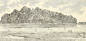
The atoll is flat and mostly bare. It has some scattered grasses and a few coconut palms. The land around the lagoon is about 1.7 square kilometres (0.66 sq mi) and is usually 2 m (6.6 ft) high. There is one small volcanic rock called Clipperton Rock. It rises to 29 m (95 ft) on the southeast side.
Clipperton Rock is what is left of an old volcano. Because of this rock, Clipperton is not a "true" atoll. The reef around the island and the weather make it hard to land boats. It is also dangerous for large ships to anchor nearby.
Studying Clipperton's Environment
Scientists have studied Clipperton Island's environment for a long time. The first studies and collections were done in the 1800s. Today, scientists mainly focus on climate change and migrating animals.
Many research trips have visited the island. In 1997, the SURPACLIP trip studied the ocean around Clipperton. In 2001, the French Passion 2001 trip looked at how the island's ecosystem was changing. In 2003, a filmmaker stayed on the island for 41 days to record its story for National Geographic Explorer.
In 2005, a four-month science trip led by Jean-Louis Étienne listed all the minerals, plants, and animals. They also studied algae deep in the ocean and looked at pollution. In 2008, a team from the University of Washington studied mud from the lagoon. This helped them learn about climate change over the last 1,000 years.
The Lagoon of Clipperton Island
Clipperton is a ring-shaped atoll with a completely enclosed fresh water lagoon. The lagoon is about 12 km (7.5 mi) around and 720 hectares (2.8 sq mi) in area. It is the only coral island in the eastern Pacific. The lagoon has no fish and is shallow in many places. However, some deep spots go down 43–72 m (141–236 ft). One spot is called Trou Sans Fond (meaning 'the bottomless hole') and has acidic water at the bottom.
The water in the lagoon is almost fresh at the top and very rich in nutrients. Seaweed covers about 45% of the lagoon's surface. The land around the lagoon is usually 150 m (490 ft) wide. In some places, ocean waves can wash over into the lagoon. There are ten small islands inside the lagoon, and six of them have plants.
The lagoon closed off from the ocean about 170 years ago. This made it a special type of lake called a meromictic lake. The bottom of the lagoon has old coral heads from when it was connected to the sea. The surface of the lagoon has many tiny plants called phytoplankton. The water layers do not mix, so the top layer has oxygen and is a bit salty. The deeper layer has no oxygen and is very salty with hydrogen sulfide. This prevents coral from growing there now.
Scientists have found many tiny living things in the lagoon's water. Some are similar to those found worldwide, while deeper water has many different types of bacteria. In 2005, French scientists found three new types of tiny algae in the lagoon. The lagoon also has millions of isopods, which can give a painful sting.
Some people say the lagoon water is not safe to drink. But in 1962, nine sailors were stranded on the island for 23 days. They said the lagoon water was "muddy and dirty" but drinkable, and they had no bad effects. Mexican colonists in 1917 drank rainwater. American soldiers in World War II had to use machines to clean the lagoon water to drink it.
Climate of Clipperton Island
The island has a tropical climate, meaning it is warm all year. Temperatures are usually between 20–32 °C (68–90 °F), and can reach 37.8 °C (100.0 °F). It rains a lot, between 3,000 to 5,000 millimetres (120 to 200 in) each year. The air is very humid, usually 85% to 95%. The drier months are from December to March.
Strong winds blow from the southeast. The rainy season is from May to October. Tropical storms can happen from April to September, but they often pass northeast of Clipperton. The ocean water around the island is warm and has gotten warmer due to global warming.
Plants and Animals of Clipperton Island
When scientists visited in 1898, they said no land plants were native to the island. Early reports from the 1700s and 1800s described low grasses and small shrubs. In 1958, the plants included spiny grass, low bushes, a creeping plant, and coconut palms. Most of these plants are thought to have arrived recently.
Coconut palms and pigs were brought to the island in the 1890s by guano miners. The largest group of coconut trees is called Bougainville Wood. On the northwest side, common plants include Cenchrus echinatus and Sida rhombifolia. The small islands in the lagoon have plants like Cyperaceae and Ipomoea pes-caprae.
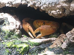
The only land animals are two types of lizards (geckos and skinks), bright-orange Clipperton crabs, birds, and ship rats. The rats likely arrived from shipwrecks in 1999 and 2000.
The pigs brought in the 1890s ate many crabs. This allowed grass to cover about 80% of the island. In 1958, all the pigs were removed. After this, most of the grass disappeared because the crab population grew again. Now, Clipperton is mostly sandy. Only 674 palms were counted in 2001, and five small islands in the lagoon have grass that the crabs cannot reach. A 2005 report said that rats are harming bird nests and crab populations. This has led to more plants and coconut palms. The report suggested getting rid of the rats to help the island return to its natural state.
In 1825, a captain reported seeing green sea turtles nesting on Clipperton. But later trips have not found nesting turtles. This might be because of the guano mining, pigs, and rats. Other animals like fur seals and elephant seals were also reported in 1825 but have not been seen since.
Many birds live on the island. In 1825, a visitor said the island was "literally covered with sea-birds." Thirteen types of birds breed on the island, and 26 other types visit. Clipperton is an Important Bird Area because it has a huge colony of masked boobies, with 110,000 birds. Other birds seen include white terns, sooty terns, brown boobies, and frigatebirds. Ducks and moorhens have been seen in the lagoon.
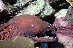
The coral reef on the north side of the island has coral colonies over 2 metres (6.6 ft) high. Many unique species live in the reefs around Clipperton, with over 115 species identified. Five or six of these species are found only here. These include the Clipperton angelfish and Clipperton grouper. Other common fish are Pacific creolefish, blue-and-gold snapper, and various types of goatfish.
The waters around the island are an important place for young sharks to grow. This includes the white tip shark, Galapagos shark, and hammerhead shark.
Scientists have collected sponges from Clipperton. In 1938, U.S. President Franklin D. Roosevelt visited and collected sponges. Out of 190 sponges collected, 20 species were found. Nine of these are found only at Clipperton. One unique sponge was named Callyspongia roosevelti after President Roosevelt.
Environmental Threats to Clipperton Island
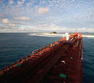
In 2010, a large ship called the Sichem Osprey ran aground on Clipperton. It was carrying chemicals, but luckily, there were no leaks. The ship was later moved.
In 2012, visitors found a lot of trash on the island, especially on the northeast shore. Plastic bottles and containers can harm the island's plants and animals. This trash is mostly on two beaches, while the rest of the island is clean. Other trash was left behind by people who lived on the island in the past.
Many fish are caught around Clipperton, but a lot of it is illegal fishing. This includes catching lobsters and shark finning. This causes losses for France.
Deep-sea mining for special rocks called polymetallic nodules is increasing nearby. Similar mining in France's waters around Clipperton could affect sea life. These nodules were found in Clipperton's waters in 2015.
Politics and Government
Clipperton Island is a special property of France. It is directly controlled by the French Minister of the Overseas. The island is French territory, but it is not part of the European Union.
France and Mexico argued over who owned Clipperton in the past. This was settled in 1931 by an arbitration decision. The Clipperton Island Case is still studied in international law classes.
In the late 1930s, Clipperton was thought of as a possible stop for planes flying across the Pacific. However, France was not interested in building an airport there.
In 1996, France confirmed its special fishing zone around Clipperton. In 2018, France expanded this zone to cover 431,273 square kilometres (166,515 sq mi) of ocean.
In 2007, the way Clipperton was managed changed. It moved from being controlled by French Polynesia to being directly under the Minister of Overseas France.
In 2015, a French politician named Philippe Folliot visited Clipperton. He was the first elected French official to do so. After his visit, he told the French government that France needed to show its control over the island. He also suggested building a science station and changing how the island is managed.
In 2022, France officially started calling the island "La Passion–Clipperton."
History of Clipperton Island
First Sightings and Claims
There are different ideas about who first saw Clipperton. Some say it was seen by Spanish explorers in the early 1500s.
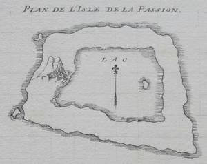
The island was first clearly mapped by French merchant Michel Dubocage in 1711. He arrived on April 3, 1711, and named it Île de la Passion (Passion Island). This was because the day he found it was during a religious period called Passiontide. They drew the first map and claimed the island for France.
In 1825, American sea captain Benjamin Morrell was the first to land on Clipperton. He explored the island and wrote a detailed report about its plants.
The island's common name, Clipperton, comes from John Clipperton. He was an English pirate in the early 1700s. People say he sailed past the island and might have used it as a base.
Mexico's Claim (1821–1858)
After Mexico became independent in 1821, it took over lands that Spain used to own. Since Spanish records mentioned the island in 1528, Mexico included it as its territory. The Mexican constitution of 1917 even named the island as part of Mexico. This changed in 1934 after the island was given to France.
France's Claim (1858)
In 1858, French Emperor Napoleon III officially took Clipperton as part of France. A French naval officer published a notice in Hawaiian newspapers to make France's claim stronger.
Guano Mining (1892–1905)
In 1892, an American company tried to claim the island to mine guano. The U.S. government said no because France had already claimed it.
Even without U.S. approval, the Oceanic Phosphate Company started mining guano in 1895. At its busiest, about 25 men worked there. They sent guano to Honolulu and San Francisco. In 1897, French navy officers found three Americans working on the island and told them to take down the American flag. A few weeks later, Mexico sent its own ship and soldiers to claim the island. They removed the Americans and raised the Mexican flag. From 1898 to 1905, a British company mined guano under an agreement with Mexico.
Mexican Colony (1905–1917)
In 1905, Mexico made a new deal with the British company. A year later, Mexico set up a military base and built a lighthouse on the island. Captain Ramón Arnaud became the governor. He was chosen to protect Mexico's claim.
By 1914, about 100 people lived on the island. A ship from Acapulco brought supplies every two months. But when the Mexican Revolution got worse, the supply ships stopped coming. The people were left alone. In 1914, a ship wrecked on Clipperton. Four crew members tried to row to Acapulco for help. Months later, a U.S. Navy ship arrived and offered to rescue the colonists. But Captain Arnaud refused, thinking a supply ship would come soon.
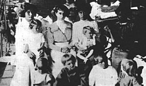
By 1917, almost all the men had died from illness or trying to get help. The lighthouse keeper, Victoriano Álvarez, was the last man left with 15 women and children. He became very controlling. The remaining survivors were rescued in 1917, and the island was abandoned.
Final Decision on Ownership (1931)
France kept saying it owned Clipperton during Mexico's time there. In 1909, both countries agreed to let the King of Italy, Victor Emmanuel III of Italy, decide who owned the island. In 1931, the King decided that Clipperton belonged to France. Mexico accepted this decision. France officially took control of Clipperton on January 26, 1935.
U.S. Presidential Visit
U.S. President Franklin D. Roosevelt visited Clipperton in July 1938 during a fishing trip. He and his group fished for sharks. Scientists with him collected samples and studied the island.
American Occupation (1944–1945)
In April 1944, the U.S. Navy checked Clipperton Island. They made sure no one was living there. Then, in December 1944, U.S. Navy ships arrived with people and equipment to build a weather station. The sailors at the station were armed in case of a Japanese attack. Landing on the island was very difficult, and some ships got stuck.
Once the weather station was built, the U.S. told France and Mexico about it. The 24 sailors at the station sent up weather balloons every day to gather information. Clipperton was also considered for an airfield to help planes fly between North America and Australia.
France was not happy about the U.S. building a station on its territory. They sent a formal protest. The U.S. offered to let the French military run the station or leave it. French officials tried to send their own people to the island, but Mexico stopped them at the request of the U.S.
As World War II ended, the U.S. Navy started leaving Clipperton in September 1945. They destroyed some military supplies but left a lot of equipment behind. By October 21, 1945, the last U.S. Navy staff left the island.
After World War II
Since the U.S. left, sports fishermen, French navy patrols, and Mexican fishermen have visited Clipperton. There have also been scientific trips and amateur radio expeditions. In 1978, Jacques-Yves Cousteau visited to film a TV special about the island.
In 1958, a scientist named Kenneth E. Stager visited. He was upset that wild pigs were killing many birds. He killed all 58 pigs on the island. By 2003, the bird populations had grown a lot. Clipperton became home to the world's second-largest brown booby colony and its largest masked booby colony.
In the 1960s, France thought about using Clipperton for nuclear testing. But they decided against it because the island was too remote and had a harsh climate. However, a small French science mission stayed there from 1966 to 1969. They watched the island and its waters, observed weather, and checked an old airstrip.
In the 1980s, there were plans to open the lagoon and build a fishing port. But these plans were too expensive and were abandoned. An automatic weather station was set up in 1980 to send data by satellite.
In 1981, a French group suggested building an airport and fishing port on the island. This would mean digging a channel to connect the lagoon to the ocean. The French government changed how Clipperton was managed, putting it directly under the Overseas Minister. In 1986, plans for a fishing port were discussed, but nothing was built. The French government also tried to get people from French Polynesia to live on Clipperton, but these plans also failed.
In 1994, the French Space Agency asked NASA for help. They wanted to track a new rocket, Ariane 5, from Clipperton. But the rocket broke apart shortly after launch.
Even though Mexico accepted that Clipperton was French, Mexican fishing boats still wanted to fish in its waters. A treaty in 2007, confirmed in 2017, allows Mexican fishermen to fish there if they get permission and follow rules. But it is hard to check if they follow the rules because France does not patrol the area often.
Castaways on Clipperton
Clipperton has a history of people getting stranded there. In 1893, two men were left on the island by a mining company for 90 days. They ate seabird eggs to survive until they were rescued.
In 1897, a British cargo ship wrecked on Clipperton. The crew saved food and water and lived on the island. Eight of the men rowed a lifeboat to Acapulco for help, and the rest were rescued by a British ship.
In 1947, five American fishermen were rescued after being stranded for six weeks.
In 1962, nine crewmen from a sunken tuna boat were stranded for 23 days. They said the lagoon water was drinkable, but they preferred coconut water. They built a shelter from old cement bags and tin. They ate fish from the reef and some vegetables they saved. They tried eating bird eggs but found them bad. They were eventually found by another fishing boat and rescued by the U.S. Navy.
Amateur Radio DX-peditions
Clipperton is a popular spot for amateur radio groups. This is because it is so far away, and it is hard to get permission to visit. Many major radio expeditions have taken place there.
In March 2014, the Cordell Expedition combined a radio trip with scientific studies. A team of 24 radio operators made over 114,000 contacts, which was a new record. They also used cameras on kites to take pictures of the island. The team included scientists and a French TV crew.
In April 2015, another amateur radio operator used the callsign TX5P during a scientific trip to Clipperton. He also researched Mexico's use of the island in the early 1900s.
See also
 In Spanish: Isla Clipperton para niños
- Uninhabited island
- Lists of islands
 | Janet Taylor Pickett |
 | Synthia Saint James |
 | Howardena Pindell |
 | Faith Ringgold |


